1 Brief History of U.S. Transportation Policy and Traffic Congestion: A Persistent Transportation Planning Issue
Chapter overview
The first part of this chapter offers a concise timeline highlighting key federal transportation policies aimed at addressing traffic congestion and promoting multi-modal transportation networks. It also presents a snapshot of the intertwined roles undertaken by the federal, state, and local governments in shaping surface transportation in the United States.
The second part comprehensively includes several sections that provide a survey of traffic congestion, one of the most challenging and complex urban transportation issues worldwide. Accordingly, it delves into topics such as the leading causes and impacts of traffic congestion, different categories of congestion, and differences in congestion based on travel demand in space and time. Additionally, it broadly discusses other congestion-related issues, including the effects of traffic congestion on mobility and accessibility. It closes by discussing traditional and emerging transportation planning approaches for reducing and mitigating traffic congestion. This discussion lays the groundwork for the next chapter, which delves into urban transportation planning and modeling.
Chapter Topics
- U.S. Federal Legislation in Transportation: A Brief History
- Traffic Congestion: A Persistent Transportation Planning Issue
- Mobility and Accessibility
- A Shifting Paradigm for Addressing Congestion
- Conclusion
- Quiz
- Glossary
- Acronyms
Learning Objectives
Learning Objectives
- Describe the relationship between U.S. transportation policy and traffic congestion.
- Explain the impacts of traffic congestion, one of the most challenging transportation issues in urban settings.
- Summarize the leading causes and impacts of congestion, different categories of congestion, and the differences of congestion based on travel demand in space and time.
- Compare the dimensions and measures of congestion and their effects on mobility and accessibility.
- Explain the difference between mobility and accessibility.
- Analyze the approaches for mitigating traffic congestion and their outcomes for equitable transportation.
Introduction
Traffic congestion, which has long hindered the movement of people and goods, traces its origins back to a time before widespread motorization. Even prior to the dominance of automobiles, congestion was concentrated in urban centers, at bridges, and within ports. The advent of mass automobile production in the early 20th century further exacerbated these challenges. This prompted the federal government to take action in 1916, enacting policies aimed at aiding and coordinating the efforts of state and local governments in the construction of new roads. These 1916 policies laid the foundation for the cooperative relationship that exists between states and the federal government today. Subsequent transportation acts have been a response to the country’s major transportation needs, traffic congestion being a prominent one among them.
The leading cause of traffic congestion is the imbalance between travel demand and supply that originates from several factors, such as inadequate transportation facilities, dependency on private vehicles, and population growth. Overall, two categories of traffic congestion exist: 1. recurring (somewhat predictable) and 2. non-recurring (less predictable). The side effects of traffic congestion primarily impact the economy, health, and environment. Therefore, many congestion-reduction and mobility improvement strategies have been suggested, such as enhancing the public transit system, expanding road capacity, reducing private vehicle usage, managing lanes, and adding bicycle lanes, among others. The proper strategies for reducing traffic congestion vary from city to city, are context-dependent, and according to the Federal Highway Administration (FHWA, 2015, n.p.), they should be 1. targeted at specific problems and 2. used in combination, rather than individually.
Part A: U.S. FEDERAL LEGISLATION IN TRANSPORTATION: A BRIEF HISTORY
The history of federal legislation addressing urban traffic congestion in the United States is a journey of more than a hundred years that reflects the evolving nature of transportation challenges in our growing cities. Over the years, expanding urbanization and concomitant traffic congestion required more efficient transportation systems. This forced the federal government to develop policies for addressing traffic congestion, mitigating its effects, and enhancing mobility.
The Federal Aid Road Act of 1916 laid the foundation for the federal-aid highway program, in partnership with the states, for road construction throughout the nation. While focused on building rural (postal service) “post roads” and not on addressing traffic congestion, the act laid the framework for future transportation legislation that would later address traffic-related issues. The act’s implementation led to the creation of a national highway organization with each state having “a highway agency with engineering professionals to carry out the federal-aid projects” (FHWA, 2022, n.p.). This was the early predecessor of the Federal Highway Administration (FHWA).
Another significant turning point came with the Federal-Aid Highway Act of 1956, also known as the National Interstate and Defense Highways Act. This landmark legislation aimed at building a vast network of high-quality interstate highways, which not only improved connectivity between cities but also was intended to play a role in alleviating traffic congestion within urban centers.
The I966 Federal Department of Transportation Act (Transportation Act) established the U.S. Department of Transportation (US DOT). It specified coordination and supervision of several federal agencies, including the Federal Highway Administration (FHWA) and the Federal Transit Administration (FTA). In addition, it authorized transportation investment standards “for the formulation and economic evaluation of all proposals for the investment of Federal funds in transportation facilities or equipment” (Department of Transportation Act, 1966, p. 941).
As the nation’s urban areas continued to expand, the federal government recognized the need for more direct measures to tackle congestion. In 1991, the Intermodal Surface Transportation Efficiency Act (ISTEA) emerged as a ground-breaking legislation that promoted an inter-modal approach to transportation planning. By encouraging the integration of various transportation modes, including public transit, cycling, and walking, ISTEA sought to reduce congestion by supporting viable alternatives to driving.
ISTEA provided funding for more than vehicular infrastructure and the expansion of the national road network. Included in the landmark bill was funding for active transportation modes (pedestrian and bicycle infrastructure) and environmental impacts, addressed with criteria for air quality and congestion, known as the Congestion Mitigation and Air Quality Improvement Program (CMAQ). Since 1991, there have been several federal transportation funding bills specifically for funding transportation improvements in support of the U.S. Department of Transportation’s mission. Over the decades, with each subsequent bill, environmental quality and social equity have gained an increasingly prominent role in transportation planning and programming.
Summarized below are notable surface transportation funding bills passed since the Intermodal Surface Transportation Efficiency Act (ISTEA) of 1991.
- Transportation Equity Act for the 21st Century (TEA-21) – Building on ISTEA’s foundation, TEA-21, enacted in 1998, provided significant funding for transportation infrastructure. It aimed to address congestion, improve safety, and enhance mobility. The bill introduced several innovative financing mechanisms and established programs to support transit, highways, and other transportation modes.
- Safe, Accountable, Flexible, Efficient Transportation Equity Act: A Legacy for Users (SAFETEA-LU) – Passed in 2005, SAFETEA-LU was a major transportation funding bill. It aimed to promote safety, environmental sustainability, and economic competitiveness. It funded a wide range of transportation projects, including highways, bridges, transit systems, and rail infrastructure.
- Moving Ahead for Progress in the 21st Century (MAP-21) – Enacted in 2012, MAP-21 aimed to modernize and streamline the transportation system. It focused on improving safety, reducing project delays, and promoting innovation. The bill introduced performance-based planning and programming, encouraging states to set performance targets and prioritize investments accordingly.
- Fixing America’s Surface Transportation (FAST) Act – Passed in 2015, the FAST Act was a five-year funding bill that provided resources for transportation infrastructure projects. It aimed to improve the condition of highways, bridges, and transit systems, while also promoting innovation and addressing the needs of rural communities. The bill included provisions to accelerate project delivery and enhance freight movement.
- Infrastructure Investment and Jobs Act (IIJA) of 2021, also known as the Bipartisan Infrastructure Deal, prioritizes infrastructure maintenance and environmental and economic justice for historically underserved communities. Chapter Four further elaborates on this important federal act and subsequent executive orders specifically addressing social justice and equity. For instance, in 2022, the U.S. Department of Transportation (USDOT) responded with an Equity Action Plan, aligned with the objectives of the President’s Executive Order 13985: Advancing Racial Equity and Support for Underserved Communities Through the Federal Government (The White House, 2021). This plan aims to implement the executive order by expanding access and opportunity for all communities, with a particular emphasis on underserved and disadvantaged communities. The Action Plan acknowledges the detrimental impacts that past federal transportation acts and associated investments, such as highways routed through marginalized neighborhoods, have had on black and brown communities. These impacts persist to date due to the durability of physical infrastructure, which continues to affect the well-being of these communities. Additionally, disparities in transit availability have resulted in transit deserts that disproportionately affect the communities most in need of reliable public transportation options (USDOT, 2022).
Today, as urban areas face new challenges beyond traffic congestion, such as economic, climate change, and social equity issues, the latter associated with the rise of online shopping delivery services, ridesharing services, and the potential full deployment of autonomous vehicles, federal government legislators must remain actively engaged in developing policies to support safe, sustainable, resilient, and more equitable urban transportation systems. Critically understanding the history of federal legislation in transportation offers valuable insights into the evolving and complex relationship between transportation policy and urban development. It also offers lessons about the way transportation policy has influenced planners’ views and how they’ve tackled transportation planning problems.
In the United States, transportation planning and programming starts at the federal level with legislation establishing federal transportation agencies, bills allocating funding, and presidential executive orders with specific directives to federal agencies. States are authorized to administer the laws and, in turn, adopt state legislation that enables local and regional agencies to craft plans and program infrastructure improvements in compliance with state and federal laws and criteria. The diagram below illustrates the interconnected relationship among federal, state, and local transportation agencies in 2011. The funding streams are intertwined, with the federal government primarily providing grants to states and localities. Despite the federal government not making direct investments in transportation infrastructure, states and localities combine federal, state, and local resources to support surface transportation initiatives.
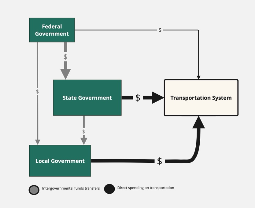
Federal revenue mainly originates from excise taxes on motor fuel, commonly known as the “gas tax,” which has remained unchanged since 1993 (18.4 cents per gallon for gasoline and 24.4 cents per gallon for diesel). This revenue contributes to two accounts within the Highway Trust Fund (HTF): 1. the Highway Account for highway and bridge construction and maintenance, and 2. the Mass Transit Account for public transit support. The lack of inflation adjustment for gas tax revenues, plus increased fuel efficiency of gas-powered vehicles and more hybrid and electric cars on the road, have led to significant shortfalls in the fund.
According to the Congressional Budget Office (CBO) data from 2019, federal spending on roads through the Federal-Aid Highway Program (HTF) amounted to $46 billion in grants to state and local governments. However, these entities contribute approximately three times that amount from their own funds annually for road construction, operation, and maintenance (CBO, 2020).
PART B: TRAFFIC CONGESTION: A PERSISTENT TRANSPORTATION PLANNING ISSUE
The word “traffic” was used eleven times in the 1966 Transportation Act. In contrast, in 2017, the U.S. Department of Transportation (USDOT) released a comprehensive report, “Beyond Traffic 2045,” that emphasized many additional congestion-related factors, such as population growth, climate change, emerging technologies, and infrastructure needs as critical transportation challenges the United States would face over the next three decades. The report uses the word “congestion” 151 times, and as the title indicates, increasing traffic congestion is one of the key issues examined in the context of six major trends along with an exploration of policy options (US Department of Transportation, 2017, pp. 3-6). The report is summarized in the bullet points below:
- Growing population increasing by 70 million and 75 % of the total US population expected to be concentrated in eleven emerging megaregions. Policy options for addressing congestion:
- Increase road capacity (build new roads and facilities) and maintain and use the road network more effectively.
- Land-use policies promoting walking, biking, transit, and mobility on demand.
- Telework, flex-time work.
- Freight volumes spiking by more than 40% due to online shopping contributing to traffic congestion. Policy options for addressing freight and road congestion:
- Improved freight planning and coordination at national, regional, and local levels.
- Innovations for solving first and last-mile freight issues.
- Global warming and mean sea levels rising with more extreme weather events affecting the transportation system infrastructure and its smooth functioning. Policy options for a more resilient infrastructure:
- Growth in electric vehicles (EVs) with potential to reduce greenhouse gas (GHGs) emissions.
- Incentivize sustainable development patterns and IT solutions for reducing GHGs emissions.
- Automation and robotics affecting all modes of transportation. Policy options for smart transportation systems:
- Leverage the opportunity of automation and robotics to improve all modes of transportation, travelers’ experience, and infrastructure management and operations; and to enable mainstream use of autonomous vehicles (AVs).
- Equity in transportation requiring growing the opportunity shares of middle and low-income American households who spend over 20% of their income on transportation and 40% on housing. Policy options for a more equitable transportation system accessible to all Americans:
- Target investment to communities with the greatest need ensuring they benefit from transportation investments.
- Declining federal gas-tax revenues due to fuel efficiency improvements and inflation and the failure of federal dollars to keep up with the country’s transportation needs. Policy options to align decisions and dollars:
- Innovative funding mechanisms for revenue generation through new taxes, fees, tolls, and congestion pricing.
The report uses data and scenario planning to comprehensively assess current and future transportation challenges. It was intended to serve as a roadmap for policymakers, planners, and stakeholders to proactively address these challenges, while emphasizing the need for policy change, and along with it, heightened coordination at all levels of government and between the public and private sectors (US Department of Transportation, 2017).
Congestion: A gateway into this book’s chapters
The trends highlighted in “Beyond Traffic” underscore significant transportation policy and planning concerns that shape the training and practice of transportation planners. Traffic congestion, a major negative external impact of transportation systems with wide-ranging social, economic, and environmental implications, is a global urban issue that serves as a gateway to the topics explored in this book.
Chapter Two presents the long-range goals, institutional actors, stakeholders, inputs, and outputs of the transportation planning process. It introduces land-use and transportation modeling, historically driven by legislative mandates requiring metropolitan agencies to forecast travel demand to address traffic congestion.
Chapter Three, building on Chapter Two, focuses on transportation project development, programming, and evaluation—critical factors in the decision-making processes of transportation agencies.
Chapter Four examines equity in transportation, from federal policy frameworks to widely used concepts of equity framed by social, environmental, geographic, and procedural justice. Meaningful public participation, key in achieving transportation equity, is integral to all aspects of transportation planning and decision-making discussed in Chapters 2 and 3, including plan-making, programming, and project evaluation.
Chapter Five delves into the different types of transportation modes, their share in US commuting, and the importance of intermodality for passenger and freight transportation.
Chapter Six examines accessibility as the link between transportation, land use and the built environment. It distinguishes between local and regional accessibility and their relation to urban form. Under the current transportation system which emphasizes mobility and speed, regional accessibility dominates over local accessibility driving urban decentralization and the shape of expansive urban forms. The chapter also explores accessibility-based proposals seeking to address the limitation of the mobility-focused transportation paradigm.
Chapter Seven, which is devoted to public transit, examines traditional transit ridership trends and the emerging popularity of micro-transit, which fills the service gap in first/last mile areas and transit deserts. It also evaluates the transportation benefits and social costs of transit-oriented development (TOD).
Chapter Eight presents a historical overview, tracing four transportation technology eras influencing American settlement patterns—from colonial canals and industrial railroads to the motor age and the current fast-evolving smart-city era of connected autonomous mobility. It highlights the leading role of IT companies in advancing new city models and deploying them.
Chapter Nine focuses on sustainable transportation, emphasizing the principles of sustainable development and transportation from the perspectives of sustainable mobility in both planning and engineering approaches.
Chapter Ten provides a broad view of transportation in the Global South, acknowledging the diverse development trajectories across countries and continents. It discusses the challenges rapid urbanization poses to municipal efforts in providing effective mobility and traffic management and highlights innovative solutions for public transit and cycling that have become inspiring models for the Global North.
Traffic Congestion: Causes, Characteristics and Consequences
This section, dedicated to Dr. Herbert S. Levinson († 2017), highlights the causes, characteristics, and consequences of congestion, drawing insights from “Road Traffic Congestion: A Concise Guide” by Professors John C. Falcocchio and Herbert S. Levinson (2015).”
Traffic congestion remains a leading cost affecting all sectors of the economy, environment, and society. It was estimated in 2009 that in the U.S., congestion on the urban road network amounted to about $85 billion annually (HDR, 2009)—only temporarily reduced to $81 billion during the COVID-19 pandemic from 2020 to 2022. The pervasive dimensions of congestion associated with economic, social, and environmental impacts affect travel times (i.e., longer and less reliable journeys) and productivity, which lead to increased fuel consumption, greenhouse gas (GHG) emissions, and adverse effects on public health and air quality. Thus, congestion mitigation strategies have been and remain today a top concern among policymakers and transportation planners. As discussed later in the chapter, a single focus on expanding road capacity to mitigate congestion is being discouraged as policymakers and planners increasingly advocate for more integrated and comprehensive approaches to congestion management. New planning and engineering multi-strategy approaches have been developed including road pricing, operational and performance, mobility services, and other strategies for mitigating congestion while considering environmental and equity impacts. However, the latter transportation equity effects are just beginning to be researched and understood (Shaheen et al., 2019).
Defining Congestion
Congestion has been defined as the imbalance between demand and supply of transportation facilities (Falcocchio & Levinson, 2015). In other words, traffic congestion is the state of traffic flow that occurs when the road network capacity is insufficient to accommodate the travel demand stemming from the concentration of daily activities and when a high density of motor vehicles affects the normal flow of traffic, causing excess travel time (Afrin & Yodo, 2020).
Studies have reclassified the main causes of traffic congestion into three primary categories: large concentrations of demand in time and space, traffic demand that exceeds roadway capacity, and physical and operational bottlenecks (Falcocchio & Levinson, 2015, p.36). Additional factors contributing to the imbalance between travel demand and supply include:
-
- Population and urban growth, leading to increased motor vehicle use, vehicle miles traveled (VMT), longer travel distances, and infrastructure investments that cannot keep up.
- Operational or physical design deficiencies in the road network, resulting in bottlenecks.
- The age and physical condition of infrastructure.
- High population densities.
- An increase in the number of circulating motor vehicles.
- The rapid growth of delivery services.
- A lack of price signals for road users, such as marginal cost pricing (Falcocchio & Levinson, 2015; Afrin & Yodo, 2020).
Categories of Traffic Congestion
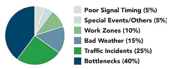
There are two significant categories of congestion: recurring and non-recurring (Figure 1.2). Recurring congestion refers to the predictable delays travelers experience regularly during morning and evening rush hours. This type of congestion occurs at expected times and locations.
Non-recurring congestion, on the other hand, is caused by unexpected incidents that disrupt traffic flow, such as car crashes or breakdowns, weather conditions, natural disasters, road repairs, or special events that generate a sudden surge in travel demand (Afrin & Yodo, 2020; Falcocchio & Levinson, 2015). Non-recurring congestion can create new traffic delays or exacerbate existing recurring congestion. According to the USDOT-FHWA, non-recurring congestion accounts for about 50% of all traffic congestion, while recurring congestion is responsible for approximately 40% (Afrin & Yodo, 2020).
Dimensions of Traffic Congestion
According to the 1997 National Cooperative Highway Research Program (NCHRP), Report 398, four dimensions are commonly used to measure congestion – duration, extent, intensity, and reliability. Collectively, they serve to quantify traffic congestion and help transportation planners and policymakers develop strategies to mitigate and manage congestion effectively.
- Duration: This dimension refers to the length of time that congestion persists on a particular roadway or transportation network. It measures how long traffic congestion lasts, ranging from brief episodes to prolonged periods of congestion.
- Extent: The extent of congestion refers to the spatial coverage or area affected by traffic congestion. It measures the portion of a roadway or transportation network that experiences congestion, whether a single intersection, a stretch of road, or an entire city.
- Intensity: The intensity of traffic congestion relates to the severity of the traffic slowdown or congestion level experienced by drivers. It measures the degree to which traffic flow is disrupted, typically through metrics such as reduced average speeds, increased travel times, or a higher density of vehicles.
- Reliability: Reliability is an overarching dimension that plays a role in each of the abovementioned dimensions. It refers to the consistency and predictability of travel times on a given route or transportation network. It assesses the variation or uncertainty in travel times due to congestion. High reliability means that travel times remain relatively consistent, while low reliability indicates greater unpredictability and variability in travel times due to congestion. The indicators of congestion and their metrics are presented in the following table (Table 1.1).
| Congestion Dimension |
Single Roadway | Corridor | Area-wide network | |
|---|---|---|---|---|
| Duration | (time system is congested) | Hours facility operates below acceptable speed | Hours facility operates below acceptable speed | Travel-time contour maps; bandwidth maps showing congested time for system sections |
| Extent | (number of people affected or geographic distribution) | % or amount of congested VMT or PMT: % of lane-miles of congested road | % or amount of congested VMT or PMT: % of lane-miles of congested road | % of trips in congestion: person-miles or person-hours of congestion; delay per PMT |
| Intensity | (level of total amount of congestion) | Travel rate; delay rate; relative delay rate; minute-miles; lane-miles hours | Average speed or travel rate; delay per PMT; delay ratio | Accessibility; total delay in person-hours; delay per person; delay per PMT |
| Reliability | (variation in the amount of congestion) | Average travel rate or speed +/- SD; delay +/- SD | Average travel rate or speed +/- SD; delay +/- SD | Travel time contour maps with variation lines; average travel/time +/- SD; delay +/- SD |
| Terms: | VMT: vehicle miles of travel | PMT: person-miles of travel | SD: standard deviation | |
| Note: Adapted from “Quantifying Congestion,” by Lomax et al., 1997, Transportation Research Board, Volume 1, p. 7. Copyright 1997 by Transportation Research Board. | ||||
Causes of Traffic Congestion
The concentration of travel demand.
Traffic congestion arises because travel demand is not evenly spread across all roads and streets in urban areas, nor are trips evenly distributed throughout the day. Activities such as working, shopping, moving and delivering goods, providing services, and recreation typically occur at specific times and places. This results in concentrated travel demand at certain times and locations. When this demand exceeds the capacity of the roadways, congestion occurs.
In essence, urban activities are concentrated in specific locations, such as employment centers, schools, and shops, and are scheduled around common timeframes, like office hours, school hours, and service times. This concentration in both space and time leads to peaks in travel demand, contributing to traffic congestion when road capacity cannot meet the demand.
Bottlenecks are a common cause of congestion in urban areas (Figure 1.3). They occur when fewer downstream roadways or lanes must accommodate more routes from upstream streets (Figure 1.4). Delays and congestion from bottlenecks typically happen during peak hours when demand exceeds road capacity (Afrin & Yodo, 2020; Falcocchio & Levinson, 2015). Physical conditions like road design, poorly timed traffic lights, or sharp curves can also create bottlenecks. Thus, a localized disruption in traffic flow on any road, street, or highway is known as a traffic bottleneck (Wikipedia.org, 2021).
| Operational Bottleneck | Construction Bottleneck |

Figure 1.3 Congestion resulting from a physical/operational bottleneck. From “A Survey of Road Traffic Congestion Measures Towards a Sustainable and Resilient Transportation System,” by Afrin & Yodo, 2020, Sustainability, 12(11) p. 4460. Attribution 4.0 International (CC BY 4.0 )
|
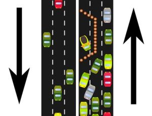
Figure 1.4 Bottleneck caused by construction. From Smurrayinchester (2017), Wikipedia.org. Creative Commons Attribution-ShareAlike License 3.0
|
The concentration of travel demand in space
In metropolitan areas, the highest concentration of travel demand occurs where employment density– defined by “employment or floor space”– is greatest, particularly in central business districts (CBDs) and large suburban centers. These areas contribute significantly to traffic congestion. Suburban areas, in particular, experience heavy traffic and congestion due to the high reliance on private cars for commuting on main highways and roads from suburb to suburb and to CBDs. Suburban parking requirements per floor area of building space and the siting of mega retail and office buildings near highway interchanges and along local arterials generate traffic congestion and bumper-to-bumper flow along major highways, corridors, and local streets. Despite the presence of public transit in some key centers, traffic congestion remains an issue in both CBDs and suburban mega-centers (Falcocchio & Levinson, 2015).
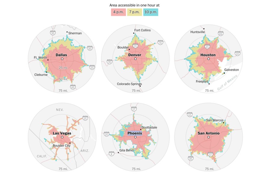
Figure 1.5 illustrates the maximum travel reach within an hour from the CBD to the outskirts of various metro areas at different times of the day (4 p.m., 7 p.m., and 10 p.m.). Peak period congestion resulting from commuting and non-work travel, railroad crossings, and natural features like mountains, rivers, and coastlines significantly impact the traveled distance.
To mitigate traffic congestion, reducing the use of private cars and expanding public transit and active transportation options (walking and biking) are widely recommended solutions. Key strategies to achieve these goals include increasing land development density and creating more diverse land uses. Data indicates that higher density leads to greater use of public transit and walking, and lower per capita VMT, which should reduce traffic congestion.
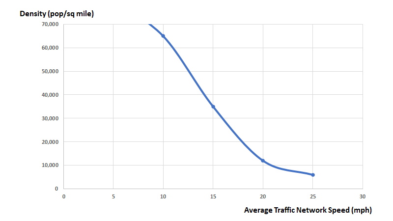
However, Falcocchio and Levinson (2015) show, using New York data (Figure 1.6), an inverse relationship between traffic speed and population density. As population density increases, traffic speed decreases, and congestion increases. This paradoxical effect of increasing urban density and the mix of land use to mitigate congestion continues to be a topic of debate—as will be discussed later in this chapter.
The concentration of travel demand in time
As earlier mentioned, the concentration of travel demand at specific times results from many daily activities (work, school, eating out, shopping, visits to services, entertainment, etc.) being scheduled at particular times. Consequently, travel patterns for these activities increase traffic and congestion during various periods. For instance, in the U.S., people typically start their commute to work around 7:00 am and leave their workplace at 5:00 pm. School trips usually start around the same time, with students returning home before 4:00 pm.
Trips are classified according to their purpose. The broadest binary categories are home-based trips (HB)and non-home-based trips (NHB), and work and non-work trips. Other classifications group trips into three categories: 1) mandatory travel (work, business, and education), 2) maintenance travel (shopping, medical, and banking), and 3) discretionary travel (social visits, recreation, and leisure). Mandatory trips are the least flexible but most consistent in time and space, while discretionary trips are the most flexible but least consistent and predictable. Due to their regularity, data on mandatory trips is easier to collect and is used for modeling travel demand and understanding their impact on traffic congestion.
Despite trip purpose classifications, in practice, they are not mutually exclusive. Many trips serve multiple purposes, such as a work trip that includes daycare drop-offs, shopping, or eating. These linked or chained trips typically occur during peak hours and vary by social and demographic factors.
More than 50% of travelers during the AM peak hours (6:00 to 10:00 AM) are work commuters. Women often drop off children at school during this time, while men tend to stop for coffee—the “Starbucks effect” (Mc Guckin et al., 2005)—more men are stopping after work during the PM peak period (3:00 to 7:00 PM) and the longer the length of the work commute, the more travelers engage in trip chaining. Senior travelers generally make medical trips during both peak and non-peak periods. Moreover, work trip chaining during peak hours has been increasing over time, along with non-work-related trips. There has been an increase in the number of workers making non-work trips during their work commutes and the number of stops made during these trips. Therefore, congestion during peak hours is not only caused by work trips but is also intensified by an increase in non-work trips during the work-commute peak hours (Falcocchio & Levinson, 2015).
Although the purpose of trips varies by mode of transportation (private vehicle, transit, walking, biking, etc.), 2019 data from before the COVID-19 pandemic shows that in the US, 84.78% of work trips were made by car, van, or truck, 4.96% by public transit, 2.65% by walking, and 0.51% by bike (USDOT/BTS, 2023, Table 2-3). This highlights the dominance of travel by motorized vehicles and the importance of mitigating traffic congestion for Americans.
Effects of Traffic Congestion
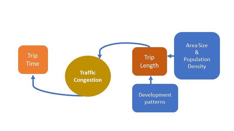
The length of a trip significantly influences how traffic congestion will impact its duration (trip time). Additionally, factors such as the size and population density of an urban area, as well as its development patterns, directly affect trip length (Figure 1.7).
The relationship between average trip length and population density, shown in Table 1.3, is graphed in Figure 1.8. For urban areas with a population density of fewer than 5,000 people per square mile, the average trip length exceeds 20 miles. However, as density increases, trip length decreases. When density rises from 5,000 to 25,000 people per square mile, the average trip length decreases by about nine (9) miles. Further increasing the density from 25,000 to 50,000 people per square mile reduces the average daily trip length to close to 12 miles.
|
Density Range (Persons per square mile) |
Daily Miles (Average miles traveled each day per person) |
|
|---|---|---|
|
0 – 99 |
31.58 |
|
|
100 – 249 |
29.95 |
|
|
250 – 499 |
29.33 |
|
|
500 – 749 |
29.00 |
|
|
750 – 999 |
26.25 |
|
|
1,000 – 1,999 |
26.17 |
|
|
2,000 – 2,999 |
23.45 |
|
|
3,000 – 3,999 |
24.11 |
|
|
4,000 – 4,999 |
24.77 |
|
|
5,000 – 7,499 |
24.56 |
|
|
7,500 – 9,999 |
20.59 |
|
|
10,000 – 49,999 |
17.02 |
|
|
50,000 or more |
12.55 |
|
|
Figure 1.8 Average vehicle trip length as a function of population density. |
||
|
Adapted from “Chapter 15: Land use and site design, Table 15-5: Average daily travel per person in the United States by population density and mode, 1990 NPTS Survey,” by Kuzmyak J R et al., in Transit Cooperative Research Program, (Eds.), “Traveler response to transportation system changes,” (p. 15-21), 2003, Washington, D.C.: Transportation Research Board. Copyright 2003 by TRB, https://trb.org/publications/tcrp/tcrp_rpt_95c15.pdf. |
||
The above indicates that travelers in low-density urban areas have longer average trip lengths compared to those in high-density areas. Consequently, the former group is more affected by traffic congestion. For example, “a delay rate of 1 minute per mile would add 15 minutes to a 15-mile trip, but only 5 minutes to a 5-mile trip” (Falcocchio & Levinson, 2015, p. 113). This underscores the importance of trip length when analyzing congestion’s impact on travelers and how land use and density can be a factor in mitigating congestion effects. However, a focus on changing land use patterns to mitigate congestion, as previously mentioned, is a topic of debate requiring a paradigm shift from the traditional view on congestion emphasizing traffic speed to one that emphasizes accessibility and trip length (Falcocchio & Levinson, 2015).
part C: MOBILITY and accessibility
This section introduces two transportation considerations discussed in greater detail in Chapter Four and throughout the book. Mobility and accessibility are also impacted by congestion and are key components of planning and programming transportation systems.
Mobility
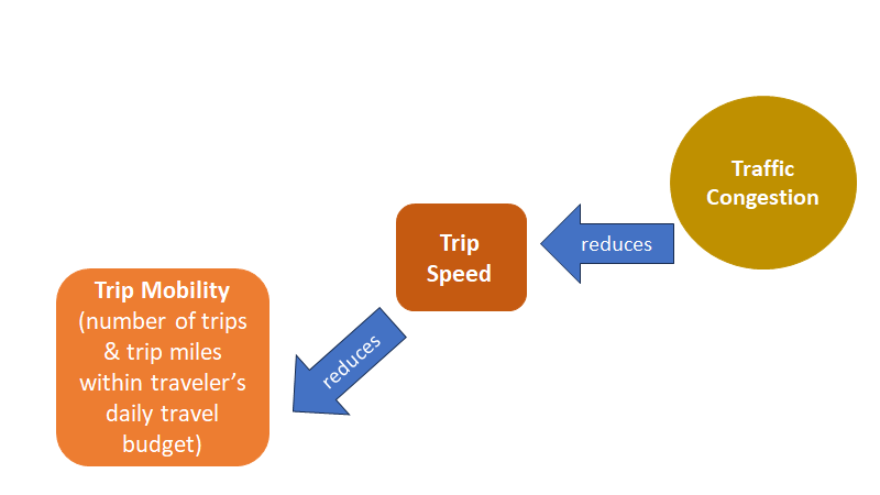
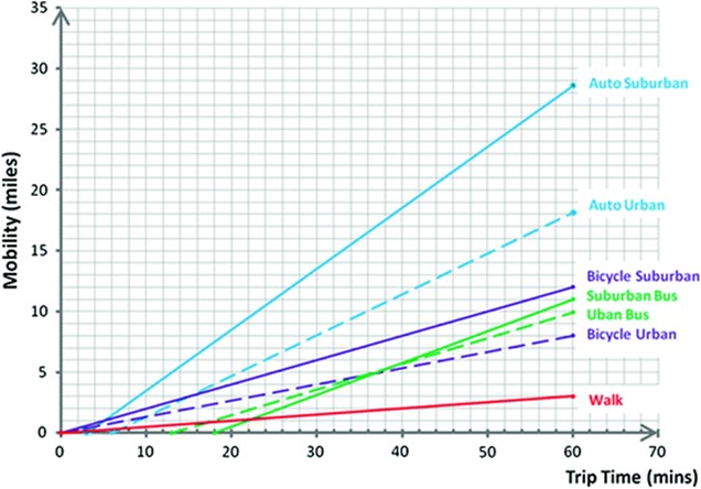
Mobility is about how easily, quickly, safely, and reliably people can travel, and goods can be shipped. Moreover, “trip mobility” identifies the distance (miles) and trips travelers take within their daily travel budget (time and cost). Thus, as shown in Figure 1.9, depending on the speed of travel, trip mobility will vary, and lower speeds affected by congestion will result in lower mobility rates (Falcocchio & Levinson, 2015). Figure 1.10 displays how traffic congestion in different cities around the world affects traffic flow reducing traffic speed.
Factors influencing mobility

According to Falcocchio & Levinson (2015), three main factors affect the traveler’s mobility, as depicted in Figure 1.10:
- Mode of transportation available to the traveler, such as walking, bicycle, bus, rail, private vehicle, etc.
- Traveler’s needs influencing mode selection such as:
- Trip purpose,
- Travel time budget,
- Disposable income determines the affordability of the trip to the traveler,
- Physical ability (to access, ride, exit, or drive), and
- Legal requirement for adult drivers to hold a driver’s license.
- Travel modes’ operational features include:
- Speed,
- Reliability (stable speeds, punctuality/dependability of service),
- Frequency (transit or other mobility service),
- Barrier-Free Access (accessible by physically disabled travelers),
- Cost (vehicle ownership, maintenance, insurance, etc.; tolls, parking charges, fuel, etc.; transit, taxi or ride-hailing fares, etc.),
- Safety (perceived risk to personal security or of injury),
- Comfort/convenience (walking distance; transit and other mobility services: number of transfers, waiting time; private vehicle: parking availability; ability to carry packages, and
- Out-of-Vehicle-time (first and last mile, waiting time for vehicles).
Measuring mobility
As mentioned, traveler mobility is defined as the distance traveled using a travel mode within the traveler’s travel time budget. Travel time budgets tend to vary depending on the size of the urban area. In small cities, a 20-minute work trip would be acceptable, whereas in a large metro area of more than five million people, a 45- to 50-minute work trip would be tolerable.
Distance traveled, or traveler mobility is calculated as:
Distance Traveled = {[speed of line by haul mode] X [(time budgeted for the trip – (excess travel time)]} + Distance from the origin to line – haul vehicle + Distance from line – haul vehicle to trip destination.
The traveled distance for different modes using the above equation and the speeds of Table 1. 4 was calculated and plotted in Figure 1.11 by Falcocchio & Levinson.
| Adapted from “Road Traffic Congestion: A Concise Guide,” (1st ed. 2015, p. 124), by Falcocchio & Levinson, 2015, New York: Springer International Publishing. Copyright (2015) by Springer. https://doi.org/10.1007/978-3-319-15165-6 | ||
|
Mode |
Urban (mph) |
Suburban (mph) |
|---|---|---|
|
Walk |
3 |
3 |
|
Bicycle |
8 |
12 |
|
Bus (mixed traffic) |
10 – 12 |
12 – 15 |
|
Auto Suburban/Urban |
15 – 20 |
25 – 30 |
Accessibility
In the transportation field, “accessibility” refers to the number of activity sites or destinations (also called opportunities) that can be reached within a certain distance or travel time. Two types of accessibility are generally distinguished in transportation studies: place accessibility and person accessibility.
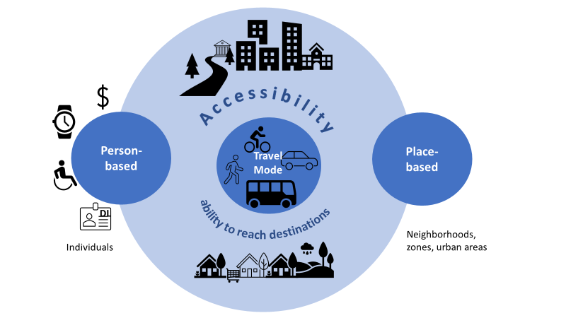
Place accessibility refers to the ability to reach destinations from a specific origin. Person accessibility refers to people’s ability (or constraints) to reach destinations from their point of origin. These constraints can include:
- Capability constraints, such as the mode of transportation, financial resources, travel time, or physical or sensory disabilities.
- Coupling constraints pertain to activities requiring copresence with other people at a particular time. For example, most types of work require to be at the employment site during work hours.
- Authority constraints involve social, political, or legal restrictions on access. Examples include requiring medical insurance to access a clinic, needing a permit to park in certain areas, needing a license to drive, and office hours that restrict access to banks or other services (Hanson, 2004, p. 6).
The two types of accessibility are related. For instance, factors influencing the accessibility of a place’s various destinations from a given location or origin include mobility mode and speed (e.g., walk, bike, transit, auto), road network condition (e.g., congestion or free flow) and connectivity (e.g., gridded road networks with multiple intersections like in downtowns vs. curvilinear road networks with few intersections like in suburbs) and the number of desired or reachable destinations (e.g., jobs, shops, school, parks, etc.) within a specified time or distance. Notably, different accessibility measures may apply to the same area depending not only on the mode of transportation used but also on the traveler’s time budget (e.g., the amount of time available to make a trip). For example, the accessibility measure for a person using public transit will differ from someone walking or driving a car. This emphasizes that personal accessibility is highly context-dependent on place characteristics (density and land-use mix, road network conditions) and travelers’ capabilities (available transportation mode, time and money budget).
Spatial accessibility
Spatial accessibility refers to the extent to which an area can be reached within an acceptable travel time. Consequently, the mobility options available within a designated travel time budget influence spatial accessibility. Different transportation modes imply different amounts of time to reach a specific destination. For instance, reaching a particular site located at a given distance might take 30 minutes by car, 60 minutes by bus, or 180 minutes on foot. Therefore, if an individual’s travel time budget is limited to 30 minutes, that location becomes accessible only by car for that person.
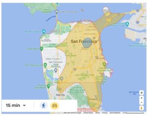
The concept of isochrones is closely related to spatial accessibility. An isochrone is a contour line on a map that connects points of equal travel time from a specific origin. It visually represents the area that can be accessed within a given time frame, considering a particular mode of transportation. Isochrones are valuable tools for analyzing spatial accessibility, as they illustrate the reachability of various destinations within different travel time budgets.
The following Google map (Figure 1.13) displays the destinations that are reachable by foot and by car within a 15-minute travel time budget from the corner of Market St. and South Van Ness Ave. in San Francisco, California. The shaded areas indicate the isochrones for both walking and driving, highlighting the difference in spatial accessibility between these two modes of transportation.
Person-accessibility
The accessibility of a person “i” to destinations like shops, jobs or dentist offices is often measured by the following index, which measures the number of activity sites or destinations and how easily they can be reached from the person’s origin (typically the home) and a given distance or time.
Place-accessibility
The accessibility of a place to other places (opportunities) in the city or region takes the following measure:
![]()
Where:
![]() = accessibility of zone i
= accessibility of zone i
![]() = number of opportunities in zone j
= number of opportunities in zone j
![]() = separation between i and j zones (in time, cost, or distance)
= separation between i and j zones (in time, cost, or distance)
![]() = a measure of “impedance” or how quickly accessibility declines with distance or time (Hanson, 2004).
= a measure of “impedance” or how quickly accessibility declines with distance or time (Hanson, 2004).
Person-based accessibility is different from place-based accessibility in that the former measures the cumulative number of potential destinations in the city reachable by an individual. The latter measures the cumulative number of places or opportunities available within the city to that place or zone. Place-based accessibility treats all residents of the place or zone as having the same level of access irrespective of individual differences (Hanson, 2004).
Accessibility and equity
Given the critical role that transportation accessibility plays in everyday life, its importance cannot be overstated, especially when considering the differences in access among various social groups. Households without cars often lack the means to reach essential opportunities like jobs and schools, relying on public transit (as shown in Figure 1.14) or having limited mobility to travel beyond their neighborhood.
In 2022, the transportation cost burden was particularly heavy on households making less than $25,000—the lowest income quintile—who spent 30% of their after-tax income on transportation, compared to just 12% spent by the highest income quintile (USDOT/BTS, 2023). Due to the pervasive equity issues in transportation, Chapter Four is devoted entirely to this topic.
Box 1.1 Equity
[. . .] Someone’s ability to reach places depends only in part on the relative location of those places; it also depends on mobility, the ability to move to activity sites, which in the United States usually requires an automobile. [. . .] the spatial organization of contemporary society demands–indeed assumes–mobility; yet not all urban residents enjoy the high level of mobility that the contemporary city requires for the conduct of daily life. Assessing the equity of a transportation system or a transportation policy requires that we consider who gains accessibility and who loses it as a result of how that system or policy is designed; it requires that we consider to what degree people’s travel patterns are the outcomes of choice or constraints. How are the costs and benefits of transportation systems shared among different groups of people?
Excerpt from “Introducing urban transportation” by Susan Hanson in The Geography of Urban Transportation, p. 9, 4th Edition, G. Giuliano and S. Hanson (Eds.), 2017. Guilford Press.
Mapping accessibility
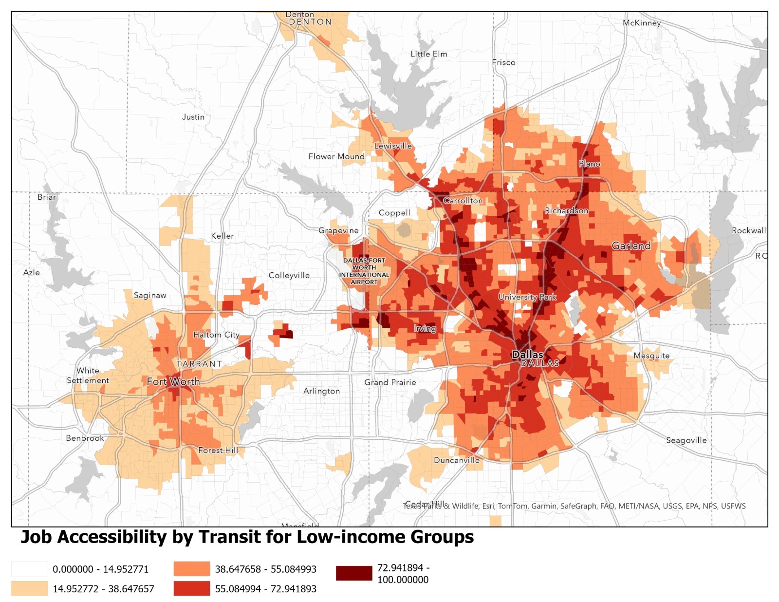
Figure 1.14 maps place-based accessibility by public transit to jobs in the Dallas-Fort Worth area for low-income, minority groups. A gravity-based accessibility index was used using transportation analysis zones (TAZs) as places. The supply of jobs is represented by the number of jobs in each destination TAZ, while job demand is represented by the number of workers in each origin TAZ, and the connecting distance between each pair of origin and destination zones is represented by transit travel time. For accuracy, a job-skill matching function was employed such that for low-skill jobs, only areas with a low-skilled labor force (gauged by education) were considered. In other words, places with job seekers were matched with places with jobs requiring their education or skills.
According to this map, places like Arlington and Grand Prairie have no accessibility to low-skill jobs by transit due to the absence of public transportation. Low-skill jobs in warehousing and light industrial businesses, abundant in these cities, cannot be reached by transit, forcing job seekers to rely on other means of transportation. However, along DART’s Red Line from Dallas to Plano, TX, running parallel to State Highway 75, accessibility to these areas’ jobs is the highest. Similarly, areas along DART’s Green Line to Carrollton and along Interstate 35-E also show high transit accessibility to low-skill jobs. In contrast, Fort Worth has very limited transit accessibility to jobs for low-skilled workers. Additionally, transit access to jobs in the wealthier suburbs of North Dallas is much more extensive compared to South Dallas, where there are more low-income, minority neighborhoods. This disparity between the location of job supply and job demand is commonly referred to as “spatial mismatch.”
Accessibility vs. Mobility
Media 1.1 Handy, S. (2019, May 20). The Institute of Transportation Studies at UC Davis (ITS-Davis) mini-lecture: Accessibility versus Mobility [Video]. YouTube. https://youtu.be/4OMv6CqrzvE?feature=shared
Congestion mitigation policies and strategies
Capacity
One of the most popular strategies for reducing traffic congestion has been to add more lanes to existing highways or build new ones. This strategy can increase the capacity of the roadway network, but it is not effective in reducing congestion in localized areas, as described by Professor Handy in the video below. In these areas, it is often more effective to improve the overall transportation system’s performance. This can include improving street connectivity and accessibility through land use planning on the one hand (as described in the above video) and, on the other, providing grade separations at congested intersections and high-occupancy vehicle (HOV) lanes. Increasing the capacity of transit systems (bus, urban rail, commuter rail) can also significantly help to reduce congestion on the roadway network (Cambridge Systematics, Inc. & Texas Transportation Institute, 2005).
Induced Travel: Resulting from Capacity Expansion
Media 1.2 Handy, S. (2020, May 15). The Institute of Transportation Studies at UC Davis (ITS-Davis) mini-lecture: Induced travel [Video]. YouTube. https://youtu.be/PzM8NZpnPOI?feature=shared
PART D: A shifting paradigm for addressing congestion
From Road Building to Enhancing System Management
The approach to addressing transportation challenges, according to the FHWA, is undergoing a substantial transformation at both regional and national levels, driven by several factors outlined below:
- Infrastructure costs
- Causes of congestion
- Technological innovations
- Customer service
Infrastructure costs
Firstly, escalating costs of conventional infrastructure solutions and shrinking transportation budgets have compelled agencies to seek more efficient management of existing transportation systems. The traditional practice of expanding capacity through road construction, lane additions, and new interchanges to alleviate congestion not only consumes space and dwindling resources but is also at odds with broader objectives such as curbing greenhouse gas emissions, reducing car dependency, promoting active transportation, and aligning urban development with land use goals.
Causes of congestion
Secondly, a deeper understanding of congestion causes has emerged. Research has revealed that while some congestion stems from typical rush hours, a significant proportion is due to non-recurring incidents like accidents, breakdowns, construction zones, adverse weather, and special events. Often, it is not constrained capacity that affects roadway efficiency, but these unexpected occurrences.
Technological innovations
Thirdly, the surge in consumer technologies (like smartphones, apps, GPS), on-demand mobility services (Uber, Lyft), and the abundance of information has heightened public expectations for smarter transportation systems, placing a greater emphasis on delivering a seamless traveler’s experience. Automation, connectivity, and the utilization of big data are transforming the way people travel.
Customer service
Lastly, travelers’ patience for delays resulting from unforeseen factors like accidents, adverse weather, work zones, and special events, is diminishing. The demand for punctual arrivals at destinations, regardless of transportation mode or road ownership, is on the rise. Travelers in urban areas particularly emphasize the desire for multi-modal options and seamless connectivity (FHWA, n.d.).
Box 1.2 Induced demand.
There is little dispute among transportation researchers that expanding highway capacity increases vehicle use. This phenomenon is commonly known as induced travel demand, and it demonstrates a fundamental economic principle: individuals tend to consume more of a good as the price of the good falls. In other words, wider highways increase traffic speeds and reduce the time cost of driving, thereby inducing additional vehicle travel. In the short run, when residential and employment locations are fixed, faster peak period highway speeds attract drivers from alternate routes, modes, and times of day. Then, in the long run, faster speeds encourage additional social and economic behavior in areas made more accessible by the new highway capacity, which further increases traffic volumes.
Research studies since the 1960s have suggested that, because of induced demand, the hoped-for benefits from highway expansion tend to be short-lived and do not provide lasting relief to traffic congestion. Early studies [ . . .] go so far as to argue that, over time and without any other offsetting deterrent, rush-hour traffic speeds tend to revert to their pre-expansion levels. The finding has even been dubbed the Fundamental Law of Road Congestion (Downs 1962), which asserts that the elasticity of vehicle miles traveled with respect to lane mileage is equal to one, implying that driving increases in exact proportion to highway capacity additions.
[. . .] Road improvements in congested areas induce additional travel indirectly, as drivers ultimately benefit from reductions in the generalized cost of driving brought about by faster traffic speeds.
[My empirical model] suggests that, over the long run, highway expansions generate an almost one-for one increase in vehicle travel. That is, the most trustworthy estimates of the induced demand elasticity are very close to one and add further support for the fundamental law of road congestion.
Congestion relief from capacity expansion vanishes within five years of capacity expansion.
What is Induced demand? Excerpt from “If you build it, they will drive: Measuring induced demand for vehicle travel in urban areas.” By Kent Hymel, 2019. Transport Policy, 76 (April) 57-66. https://doi.org/10.1016/j.tranpol.2018.12.006
Downs, A. (1962). The law of peak-hour expressway congestion. Traffic Quarterly, 16 (3).
Transportation Systems Management and Operations (TSMO) Planning
These changes have underscored the need for enhanced collaboration among cities, counties, regional agencies, and states, and the importance of establishing seamless metropolitan transportation systems. Transportation Systems Management and Operations (TSMO) is a strategy defined by the U.S. Department of Transportation, as integrated approaches for optimizing the performance of the existing transportation infrastructure. TSMO plans encompass multimodal and intermodal solutions, spanning jurisdictions, services, and projects. Their aim is to enhance a transportation system’s capacity, security, safety, and reliability. The consideration of natural infrastructure (e.g., green solutions to reduce erosion and flood risks in coastal and other roads) is also integral to this approach (FHWA, 2023). TSMO have converged with smart city strategies, a topic examined in Chapter Eight, Technology. This convergence has been enabled by recent information and communication networks that permit public and private partnerships for capturing and sharing transportation data. TSMOs provide a framework for and leverage these multijurisdictional and public-private smart city arrangements.
TSMO operates holistically, beyond traditional singular congestion strategies or projects. It coordinates a range of strategies, such as transportation demand management (TDM), congestion pricing, freight management, access management, connected and automated vehicles, transit management, and improved bicycle and pedestrian networks. These strategies are meant to collaborate across jurisdictions, agencies, and modes, treating the transportation network as a unified entity for the system’s enhanced performance. TSMO planning does not only include a wide choice of individual solutions for public agencies but more importantly, it requires interagency coordination and their integration for optimizing overall system performance.
For example, the 2010 Portland TSMO Plan combined a Transportation Management System (TMS), which typically incorporates advanced technologies to improve traffic operations with a Transportation Demand Management (TDM) component, which promotes travel options and ongoing programs that result in reduced demand for drive alone trips. Together these two transportation management techniques aimed to optimize the existing transportation infrastructure (Portland Regional TSMO Plan, 2010).
In response to the rapid changes occurring during the COVID era, such as remote work shifts, natural disasters, and technological advancements disrupting the status quo, transportation equity and social justice concerns have taken national center stage. Recognizing these challenges, the Portland Metro Region viewed its 2021 TSMO Strategy Update as an opportunity to enhance transportation equity and foster adaptability across the region. The update highlighted that while historical TSMO strategies focused on reliability, safety, traveler information, and congestion management, “the Metro region recognized that equity implications should [also] be incorporated into all of their transportation planning efforts” (Portland Metro TSMO, 2021, p. 15).
TSMO example: Texas
Media 1.3 Texas Department of Transportation (TXDOT). (2023, April 12). TXDOT: What is TMSO? [Video]. YouTube. https://youtu.be/gtf2B7xUuIQ?feature=shared
Conclusion
This chapter provided a concise historical overview of national transportation policy, often framed in response to traffic congestion challenges. It briefly discussed the decline in federal funding for conventional road expansion and introduced key concepts related to congestion. It highlighted that there is no single prescribed method for alleviating traffic congestion and that congestion issues are more pronounced in larger metropolitan areas than in smaller towns and cities.
Higher densities and mixed land uses are associated with shorter trips and greater use of transit and walking, which can help mitigate congestion. However, higher densities can also slow down traffic and increase congestion, an outcome that many suburban travelers find unacceptable. Addressing congestion by increasing density and land-use mix requires a paradigm shift from focusing on mobility and traffic speed to enhancing accessibility and reducing trip length. Accessibility in transportation is a key policy concern, especially given the equity implications for low-income populations who bear the cost burden of a system favoring automobility. These issues are further examined in this book.
Traffic management strategies are crucial for mitigating congestion and enhancing travel efficiency, mobility, and accessibility. In response to rising infrastructure costs, shrinking transportation budgets, a better understanding of congestion causes, and technological advancements, new innovations in integrated transportation management and operations systems have emerged. These systems aim to optimize the performance of existing regional transportation infrastructure using intelligent transportation systems (ITS) and multimodal and intermodal approaches across various jurisdictions. This holistic planning and engineering approach seeks to preserve capacity and improve security, safety, and reliability within the transportation system. Chapter Two focuses on transportation planning and modeling
QUIZ
Chapter 1 Quiz
Glossary
Bottlenecks are points in a transportation network where the flow of traffic is significantly slowed down due to limited capacity or high demand, leading to congestion and delays. For instance, during rush hour, the merge point where two highways converge often becomes a bottleneck, causing long traffic jams as vehicles struggle to merge smoothly.
Chained trips involve making multiple stops during a single travel journey, often combining different purposes within one trip sequence. For instance, on the way home from work, stopping at the grocery store and then picking up dry cleaning before reaching home.
Discretionary trips are non-essential trips made by choice for leisure, shopping, social activities, or other personal interests. For example, going to the mall on a weekend or visiting a friend’s house for a dinner party are discretionary\, i.e., taken voluntarily.
Federal Highway Administration (FHWA) is an agency within the U.S. Department of Transportation that supports state and local governments in designing, constructing, and maintaining the national highway system and provides financial and technical aid to ensure that America’s roads and highways remain safe and technologically advanced.
Highway Trust Fund (HTF) was created in 1956 with the Highway Revenue Act of 1956, is codified in 26 U.S. Code, §9503, and uses tax revenue, such as taxes on vehicle fuel, to support construction, operations, and maintenance of surface transportation and transit infrastructure.
Home-based trips (HB) originate from the home location and travel to the work location.
Impedance is an accessibility measure of the resistance or difficulty of traveling between two points, considering factors like distance, time, or cost. The factors are typically estimated and expressed as decay functions using negative exponential or probability or log-logistic functions.
Intelligent transportation systems (ITS) are the controlling and information systems that utilize combined communications and data processing technologies to enhance the mobility of people and goods, improving safety, decreasing traffic congestion, and handling traffic crashes.
Intermodal Surface Transportation Efficiency Act of 1991 (ISTEA) is a United States federal law that posed a major change to transportation planning and policy, as the first U.S. federal legislation on the subject in the post-Interstate Highway System era. (Wikipedia, 2013, n.p.)
Mandatory trips are trips that individuals must undertake out of necessity, often related to work, education, or essential errands. Examples include commuting to work every weekday or taking children to school.
Non-home-based trips (NHB) are trips in which neither the origin nor the destination is the home.
Speed of line by haul refers to the average speed of a travel mode (typically transit or freight) over a specific distance or route segment, reflecting the efficiency and reliability of the service. For instance, if a bus line covers a 10-mile route in 30 minutes, the speed of the line by haul is 20 miles per hour, indicating how quickly passengers can travel that segment.
Traffic flow results from the interactions between travelers and infrastructure. Flow, speed, and density are the elements of traffic flow.
Transportation Demand Management (TDM) encompasses strategies aimed at reducing congestion and improving transportation efficiency by influencing travel behavior, such as shifting travel times, routes, or modes. For example, a city implements TDM by offering incentives for carpooling, expanding bike-sharing programs, and promoting flexible work hours to decrease rush-hour traffic.
Transportation Analysis Zone (TAZ) is a designated urban area used in transportation planning to analyze travel patterns and demand within a specific geographic region. For example, TAZs might encompass residential neighborhoods, and planners study how many trips are generated in that area.
Vehicle Miles Traveled (VMT) is the aggregate number of miles driven from an area at a particular time of day.
References
Afrin, T., & Yodo, N. (2020). A survey of road traffic congestion measures towards a sustainable and resilient transportation system.Sustainability, 12(11), 4660.https://doi.org/10.3390/su12114660
Cambridge Systematics, Inc., & Texas Transportation Institute. (2005).Traffic congestion and reliability: Trends and advanced strategies for congestion mitigation-Final report. Federal Highway Administration.https://ops.fhwa.dot.gov/congestion_report/
Congressional Budget Office (CBO). (2020). Reauthorizing federal highway programs: Issues and options. U.S. Congressional Budget Office, May 2020.https://www.cbo.gov/system/files/2020-05/56346-CBO-Highway-Reauthorization.pdf.
Department of Transportation Act of 1966. Pub. L. 89-670 (1966). https://www.govinfo.gov/content/pkg/STATUTE-80/pdf/STATUTE-80-Pg931.pdf
Highway Trust Fund. Title 26 U.S.C. § 9503 (2018 edition). https://www.govinfo.gov/app/details/USCODE-2022-title26/USCODE-2022-title26-subtitleI-chap98-subchapA-sec9503
Falcocchio, J.C. & Levinson, H. S. (2015). Road Traffic Congestion: A Concise Guide (1st ed. 2015.). Springer International Publishing.https://doi.org/10.1007/978-3-319-15165-6
Federal Highway Administration (FHWA). (2015). How can we deal with congestion? Congestion and reliability: Linking solutions to problem. Chapter 4, final report. Federal Highway Administration, U.S. Department of Transportation. https://ops.fhwa.dot.gov/congestion_report_04/chapter4.htm
FHWA. (2023). U.S. Department of Transportation. What is Transportation Systems Management and Operations (TSMO)? | Transportation Systems Management and Operations (TSMO) Plans | Organizing and Planning for Operations – FHWA Office of Operations (dot.gov). Retrieved from https://ops.fhwa.dot.gov/tsmo/
Handy, S. (2019, May 20). The Institute of Transportation Studies at UC Davis (ITS-Davis) mini-lecture: Accessibility vs. mobility [Video]. YouTube. https://youtu.be/4OMv6CqrzvE?feature=shared
Handy, S. (2020, May 15). The Institute of Transportation Studies at UC Davis (ITS-Davis) mini-lecture: Induced travel [Video]. YouTube. https://youtu.be/PzM8NZpnPOI?feature=shared
Hanson, S. (2004). The context of urban travel: Concepts and recent trends. In S. Hanson & G. Giuliano (Eds.), The geography of urban transportation (3rd ed., pp. 3-29). Guilford.
HDR (2009). Assessing the full costs of congestion on surface transportation systems and reducing them through pricing. Report prepared by HDR for the Office of Economic and Strategic Analysis, U.S. Department of Transportation. February 2009. https://www.transportation.gov/office-policy/transportation-policy/assessing-full-costs-congestion-surface-transportation-systems
Kuzmyak, J. R., Pratt, R. H., Douglas, G. B., & Spielberg, F. (2003). Chapter 15: Land use and site design: Traveler response to transportation system changes. (TCRP Report 95) Transportation Research Board. https://nap.nationalacademies.org/catalog/24727/traveler-response-to-transportation-system-changes-handbook-third-edition-chapter-15-land-use-and-site-design
Lomax, T., Turner, S., Shunk, G., Levinson, H. S., Pratt, R. H., Bay, P. N., & Douglas, G. B. (1997).Quantifying congestion.(NCHRP Report 398, Article Project 7-13).http://trid.trb.org/view/475257.
Macon, A. (2017, August 14). Just how bad is Dallas’ rush hour traffic?DMagazine.http://www.dmagazine.com/frontburner/2017/08/dallas-rush-hour-traffic/
Pew Research Center, Washington, D.C. (2015). Funding Challenges in Highway and Transit. A Federal, State, and Local Analysis.https://www.pewtrusts.org/en/research-and-analysis/articles/2015/02/24/funding-challenges-in-highway-and-transit-a-federal-state-local-analysis
Portland Metro Region (2021).Transportation System Management & Operations (TSMO) Strategy. Adopted January 2022. Resolution 21-5220. 2021-Regional-Transportation-System-Management-Operations-Strategy-20220106.pdf (oregonmetro.gov)
Shaheen, S., Stocker, A., & Meza, R. (2019). Social equity impacts of congestion management strategies. UC Berkeley: Transportation Sustainability Research Center.https://escholarship.org/uc/item/9z9618mn
The White House (2021).Executive order on advancing racial equity and support for underserved communities through the federal government. Briefing Room. January 20, 2021.https://www.whitehouse.gov/briefing-room/presidential-actions/2021/01/20/executive-order-advancing-racial-equity-and-support-for-underserved-communities-through-the-federal-government/
Texas Department of Transportation (TXDOT). (2023, April 12). TXDOT: What is TMSO? [Video]. YouTube. https://youtu.be/gtf2B7xUuIQ?feature=shared
Traffic bottleneck. (2021, September 22). InWikipedia. https://en.wikipedia.org/w/index.php?title=Traffic_bottleneck&oldid=1045825368
USDOT – US Department of Transportation (2017).Beyond traffic 2045. Final Report, January 9, 2017. https://www.transportation.gov/sites/dot.gov/files/docs/BeyondTraffic_tagged_508_final.pdf
USDOT – US Department of Transportation (2022).Equity Action Plan. January 2022. U.S. Department of Transportation.https://www.transportation.gov/sites/dot.gov/files/2022-04/Equity_Action_Plan.pdf
U.S. Department of Transportation, Bureau of Transportation Statistics, TransportationStatistics Annual Report 2023 (Washington, DC: 2023). https://doi.org/10.21949/1529944
Wikipedia contributors. (2024, July 13). Intermodal Surface Transportation Efficiency Act. In Wikipedia, The Free Encyclopedia. Retrieved 19:27, August 2, 2024, from https://en.wikipedia.org/w/index.php?title=Intermodal_Surface_Transportation_Efficiency_Act&oldid=1234205268
Wikipedia contributors. (2024, August 4). Intermodal Surface Transportation Efficiency Act. In Wikipedia, The Free Encyclopedia. Retrieved 15:18, August 19, 2024, from https://en.wikipedia.org/w/index.php?title=Intermodal_Surface_Transportation_Efficiency_Act&oldid=1238560366
Weingroff, R.F. (1996). Federal Aid Road Act of 1916: Building the foundation. Public Roads, 60 (1), FHWA,https://highways.dot.gov/public-roads/summer-1996/federal-aid-road-act-1916-building-foundation
The Federal Highway Administration (FHWA) is an agency within the U.S. Department of Transportation that supports state and local governments in designing, constructing, and maintaining the national highway system and provides financial and technical aid to ensure that America's roads and highways remain safe and technologically advanced.
The Intermodal Surface Transportation Efficiency Act of 1991 (ISTEA) is a United States federal law that posed a major change to transportation planning and policy, as the first U.S. federal legislation on the subject in the post-Interstate Highway System era.
Highway Trust Fund (HTF) was created in 1956 with the Highway Revenue Act of 1956, is codified in 26 U.S. Code, § 9503, and uses tax revenue, such as taxes on vehicle fuel, to support construction, operations, and maintenance of surface transportation and transit infrastructure.
Traffic flow results from the interactions between travelers and infrastructure. Flow, speed, and density are the elements of traffic flow.
Bottlenecks are points in a transportation network where the flow of traffic is significantly slowed down due to limited capacity or high demand, leading to congestion and delays. For instance, during rush hour, the merge point where two highways converge often becomes a bottleneck, causing long traffic jams as vehicles struggle to merge smoothly.
Vehicle Miles Traveled (VMT) is the aggregate number of miles driven from an area at a particular time of day.
Home-based trips (HB) originate from the home location and travel to the work location.
Non-home-based trips (NHB) are trips in which neither the origin nor the destination is the home.
Mandatory trips are trips that individuals must undertake out of necessity, often related to work, education, or essential errands. Examples include commuting to work every weekday or taking children to school.
Discretionary trips are non-essential trips made by choice for leisure, shopping, social activities, or other personal interests. For example, going to the mall on a weekend or visiting a friend’s house for a dinner party are discretionary, i.e., taken voluntarily.
Chained trips involve making multiple stops during a single travel journey, often combining different purposes within one trip sequence. For instance, on the way home from work, stopping at the grocery store and then picking up dry cleaning before reaching home.
Speed of line by haul refers to the average speed of a travel mode (typically transit or freight) over a specific distance or route segment, reflecting the efficiency and reliability of the service. For instance, if a bus line covers a 10-mile route in 30 minutes, the speed of the line by haul is 20 miles per hour, indicating how quickly passengers can travel that segment.
Isonchrone: An isochrone is a map or diagram that shows all the points that can be reached from a specific location within a given amount of time, using a particular mode of transportation (e.g., walking, driving, public transit). It effectively illustrates the area that is accessible within a certain travel time, helping to visualize accessibility from a central point.
Impedance is an accessibility measure of the resistance or difficulty of traveling between two points, considering factors like distance, time, or cost. The factors are typically estimated and expressed as decay functions using negative exponential or probability or log-logistic functions.
Transportation Analysis Zone (TAZ) is a designated urban area used in transportation planning to analyze travel patterns and demand within a specific geographic region. For example, TAZs might encompass residential neighborhoods, and planners study how many trips are generated in that area.
Induced travel demand refers to the phenomenon where increased transportation infrastructure capacity leads to an increase in travel demand. In other words, building more roads or adding lanes to roads to deal with congestion induces more people to travel, often negating the intended benefit of reducing congestion.
Transportation Demand Management (TDM) encompasses strategies aimed at reducing congestion and improving transportation efficiency by influencing travel behavior, such as shifting travel times, routes, or modes. For example, a city implements TDM by offering incentives for carpooling, expanding bike-sharing programs, and promoting flexible work hours to decrease rush-hour traffic.
Intelligent Transportation Systems (ITS) are the controlling and information systems that utilize combined communications and data processing technologies to enhance the mobility of people and goods, improving safety, decreasing traffic congestion, and handling traffic crashes.
