2 A Brief History of Urban Transportation Planning and Key Issues
Chapter Overview
This chapter presents an in-depth examination of the historical evolution of urban growth, with a focus on the impact of various transportation technologies on the structure of cities throughout different time periods. It begins by exploring the prevalence of walking cities in ancient times and then progresses to analyze the transformative effects of advanced transportation technologies such as railways, underground rail systems, streetcars, and automobiles. Following this, the chapter provides a historical overview of legislative acts related to transportation planning and their effects on land use and transportation planning approaches. It then reviews relevant theories and key issues in land use and transportation models over the past 50 years in a chronological format. The final section of the chapter focuses on current issues, concerns, and questions within the field of transportation planning. Key topics include equity issues, environmental considerations, transportation system management, workforce management, and other pressing matters. This comprehensive exploration offers insights.
Learning Objectives
- Explain and summarize the relationship between urban form and transportation in different historical ages.
- Recognize and summarize the key concepts and practices transportation planners in the US have embraced in recent decades.
- Classify and compare different paradigms of landuse/transportation modeling in recent decades with respect to key theoretical and practical issues.
- Understand and describe today’s pressing issues and emerging trends in transportation planning research and practice
Urban form history and transportation
Rome: a walking city
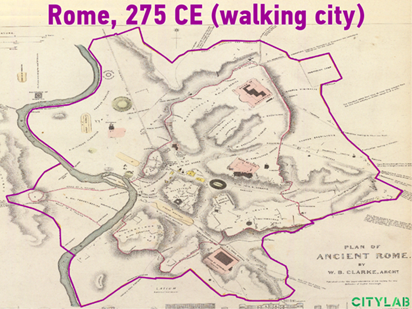
The role of transportation technologies in shaping human life, daily activities, and urban development has been significant since the early days of civilization. In the absence of transportation technology for many years, human activities were constrained by distance and physical capabilities. For instance, in ancient times, a hunter’s range of activity relied on walking or running. Despite notable advancements in transportation, such as the famous roads and buildings in ancient Rome, the absence of widespread technology meant that daily activities had limited boundaries.
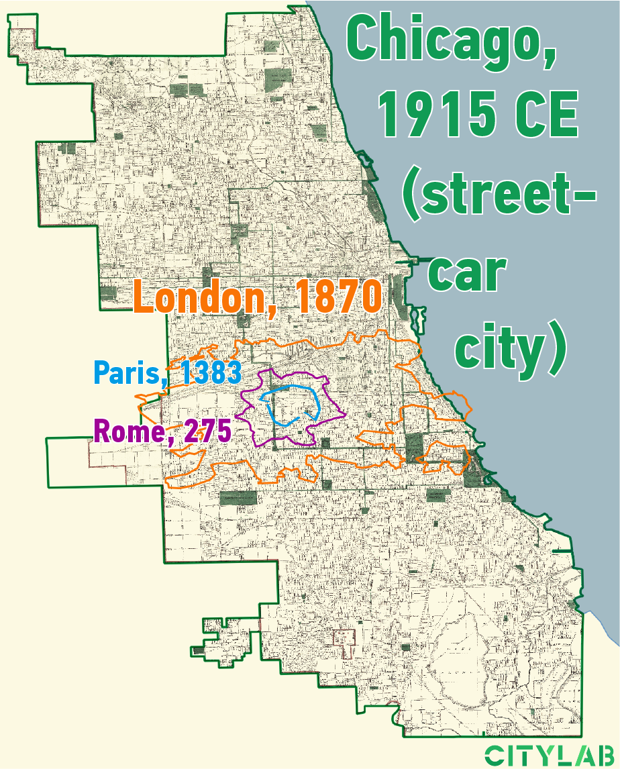
An illustration of this limitation can be seen in the ancient Olympic games nearly 2,800 years ago, where the fastest recorded speed was 10 mph. However, this speed was impractical for daily use by citizens. Consequently, social gatherings and activities were confined to a minimal and limited boundary, reflecting the urban area of the city. Ancient Rome, as depicted in Figure 2.1 from 275 Common Era (CE), functioned as a walking city, accommodating nearly 1 million people within a 2-mile diameter area (CityLab, 2019). Despite its advancements, Rome was densely populated for its time, with walking being the primary mode of commuting for various purposes, including work and errands. The use of carriages or horses was prohibitively expensive for ordinary citizens due to high maintenance costs.
Paris: still a walking city
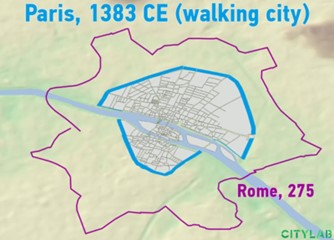
In 275 Common Era (CE), Rome was a significantly larger city than Paris, which was established over a thousand years later in 1383 CE. Rome’s population of approximately 1 million people was largely due to its status as part of a vast empire. While Paris was not as populous, it was thoughtfully designed with functional infrastructure like roads, bridges, and boats to meet its citizens’ transportation needs. Paris was divided into two parts by the river, which served as a primary transportation corridor. Despite its smaller size, Paris played a significant role in trade due to its accessibility via waterways. The city was at the center of an extensive transport system of radiating waterways. (Affleck, 1972).
London: a railway city
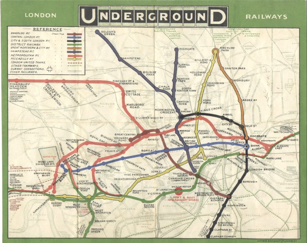
London was the first industrial city in the world along with the first to use steam power for its infrastructure, including transportation. The steam engine and railway extended the boundary of London and allowed people to leave the inner city and live in suburban areas with low-density settlements. With railway technology, citizens could commute between their homes and workplaces daily. The new transportation facility brought a significant increase in the speed of mobility, and rail stations became so attractive that many towns and suburbs formed around the major transit points. Figure 2.3 below shows London’s underground map of 1908.
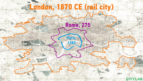
By 1870, Britain experienced probably the most critical transport revolution in history. In fact, after the Industrial Revolution, Britain witnessed a dramatic increase in travel speed and a decrease in freight and passenger transportation rates (Bogart, 2013). Such substantial changes could quickly relocate the land uses (through increased mobility and accessibility) and eventually extend city limits
The following video illustrates the evolution of the London underground system from 1801 to 2008 and the relationship between the growing system and population density in the Greater London Area.
Video 2.1 The evolution of London underground and national rail 1801-2008
Chicago: the city of streetcar and bicycle
The streetcar was the next enabling transportation advancement that connected many parts of the city significantly more widely than the railways in London. Streetcars were lightweight, and they gave citizens rides to major city streets. Figure 2.4 shows Chicago’s surface map with high connectivity of streetcars. This new transportation technology expanded the city area remarkably. A walking city with 2 miles in diameter, generates an urban area with 3 square miles. A streetcar city can extend its diameter to 8 miles and covers 50 square miles (English, 2019). Middle-class people could ride bicycles to streetcar locations and commute from outer areas to their workplaces. As a result, the first boom in suburbanization took off.
The City for Automobile
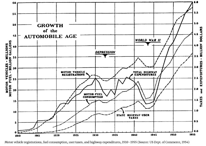
Interestingly, the same technology used for streetcars created elevators, following which cities could grow vertically and horizontally and build more dense central cities. These major changes set the stage for the ever-flourishing automobile industry. The Henry Ford Company made its debut, and the Ford Model T was the first model of private automobile manufactured affordable for the middle class. Private cars used city streets, which were already viewed as a public responsibility and required no expensive tracks and motive power systems (Cheape, 1984). As the use of streetcars and private cars became popular due to their conveniences, the underlying impact of the innovation was the expansion of the distance between origin and destination in urban areas, proving a significant and fast-paced growth of the city boundary historically. Figure 2.6 illustrates how vehicle registration, fuel consumption, taxes, and highway expenditure grew significantly from almost negligible to a record high from 1910 to 1955. During this period, the number of motor vehicles grew from less than half a million to more than nine million, and the rapid growth continued after that (MacDonald, 1950).
Due to the pervasive use of the automobile in the U.S., surface transportation planning became increasingly more important in major cities. A notable example is San Francisco in 1948, where significant freeways like the Bayshore Freeway and Mission Freeway were planned to connect city landmarks. The newly created roadway plan recommended a network system comprising freeways, expressways, and parkways in San Francisco. Between 1951 and 1955, this plan was renamed the Trafficways Plan, and the city implemented most of its suggestions. However, some proposed routes never materialized due to a protest against building superhighways in the city known as the Freeway Revolt (California Highways (Www.Cahighways.Org): Telling a Story through Highway and Planning Maps: San Francisco/Bay Area Freeway Development (Part 1—The City of San Francisco), n.d.).
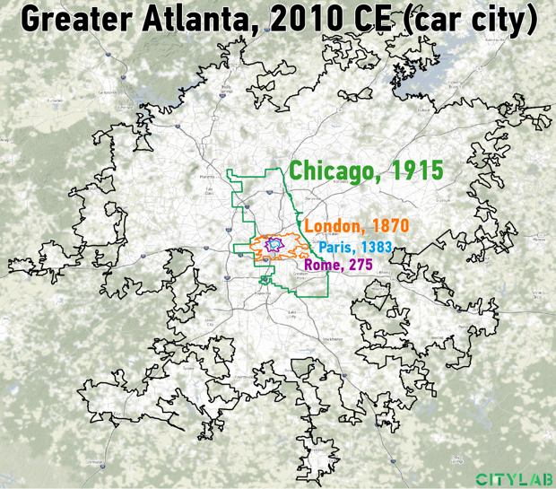
At the national level, in 1958, during the presidency of Eisenhower, a plan was outlined to construct the National System of Interstate and Defense Highway, which introduced a whole new era for transportation planning. This plan continued connections between different destinations within cities, but it also planned interstates to connect major cities across the nation. While this comprehensive project made road travel faster, easier, and even safer for all Americans, there were negative externalities like environmental damage or the destruction of old historic neighborhoods across the nation (Blas, 2010). Due to all these constructions and developments in roads and the highway system, American cities gradually formed “car cities.” The map of Atlanta in 2010 (Figure 2.7), a city much more prominent than Chicago in 1955 and the other cities discussed earlier, shows how highways float like rivers into the city and connect its different parts. As we can see, transportation technologies completely changed the face of the cities.
2.2 Transportation planning in the United States
Transportation planning practices have undergone significant evolution over subsequent decades in terms of goals, scales, and organizational structures. In 1849, the Department of the Interior took on transportation planning-related tasks, and over a century later, various Federal Highway Acts led to the establishment of the federal Department of Transportation in 1966, ensuring federal funding and support for the national transportation program. Following this, several federal transportation-related agencies were founded, including the Federal Highway Administration (FHA, 1966), the Federal Railroad Administration (1967), the National Highway Safety Bureau—later becoming the National Highway Traffic Safety Administration (NHTSA, 1970), and the Urban Mass Transportation Administration (UMTA, 1974) (Whitnah, 1998). For a more in-depth exploration of the history of transportation planning, please refer to the OERtransport book, “Transportation Policy, Planning and History.”
Federal Highway Acts (1921-1988)
To address the growing use of private vehicles, the U.S. government introduced the Federal Aid Highway Act of 1921. This legislation mandated that states establish a system of main interstate and inter-county roads, limited to 7% of the total mileage of existing rural roads. Subsequently, in 1925, another act was passed, requiring a standardized numbering system, signals, and infrastructure for all national highways. This initial interstate highway system, designed to provide guidance to motorists, was officially adopted in 1926.
In 1934, the Federal-Aid Highway Act empowered states to allocate 1-1/2% of their annual budget for construction projects benefiting the future development of the federal highway system. This initiative involved extensive efforts such as site surveying, planning, and economic analysis. The U.S. Bureau of Public Roads (now the U.S. Federal Highway Administration) collaborated with state highway departments, and by 1940, all states actively participated in this program (Weiner, 2016; Holmes & Lynch, 1957). These surveys covered various aspects, including mapping all highways, creating detailed facility inventories, and assessing travel volumes by vehicle type. Financial studies were also conducted as part of these surveys, many of which continue to be regularly carried out.
A crucial milestone in the history of U.S. transportation planning is the “National System of Interstate and Defense Highways,” a significant project that brought together planners, engineers, economists, and highway officials for its planning and implementation. The selection of the project’s route, which had a profound impact on American cities and lifestyles, was influenced by factors such as population density, manufacturing, and agricultural activities, catering to both existing and future traffic needs. According to the project report, it was deemed essential at both local and national levels to recognize the recommended system as the one that best and most directly connected regions and major cities (U.S. Congress, 1944).
This network primarily focused on the most heavily traveled routes of the Federal-Aid Primary System. As the demand for transportation within and between cities increased rapidly, the rise in automobile ownership and suburbanization underscored the necessity of projecting future travel patterns and behaviors through regional transportation modeling. The Federal-Aid Highway Act of 1962 marked a new era in urban transportation planning by mandating that approval for any highway project in urban areas with a population exceeding 50,000 be contingent on the development of a continuing, comprehensive, cooperative (the 3C process) urban transportation planning process jointly developed by state and local governments.
This act introduced two novel aspects to urban transportation planning. Firstly, it advocated for conducting transportation planning on a regional and metropolitan scale rather than solely at the national or local level. Secondly, it emphasized cooperation between local communities and state governments. The Bureau of Public Roads, later rebranded as the Federal Highway Administration (FHWA), sponsored research aimed at standardizing travel demand modeling nationwide. This effort led to the development of the Urban Transportation Modeling System (UTMS), based on a four-step travel demand modeling approach, with further details provided in the third section of the book.
During the 1950s and 1960s, planning agencies primarily focused on freeway and automobile-based development plans, utilizing travel demand models to pinpoint congested corridors for improvement projects. As the 1970s and 1980s unfolded, environmental and equity concerns gained prominence. During this period, travel models evolved to become more statistically accurate and sophisticated, incorporating disaggregate choice models for analyzing travel behavior.
In the 1960s and 1970s, escalating worries about congestion and the environment led to significant developments. In 1969, the National Environmental Policy Act (NEPA) was enacted, mandating detailed environmental assessments for all federally funded projects. Despite these efforts, the widespread increase in Vehicle Miles Traveled (VMT) persisted in almost all regions. Consequently, many urban areas turned to mass transit systems, including light rail systems in central cities.
The Federal-Aid Highway Act of 1970 played a pivotal role by establishing the Federal-Aid Urban Highway System. This act recommended the construction of intra-urban highway systems to connect major centers, emphasizing collaboration between local and state officials. The 1970s Federal-Aid Highway Act introduced the requirement to consider negative externalities (economic, social, environmental) in project development, necessitating an assessment of the overall public interest before construction could proceed.
The Federal-Aid Highway Act of 1973 marked a significant shift by allowing funds allocated for highway development to be utilized for mass transportation, a change that took full effect after 1976. Specifically, this meant that funds earmarked for interstate highway projects could be converted from the general fund and directed towards mass transportation projects within a particular state. This shift provided ample opportunities for advocates of public transit improvement and established a consistent source of federal assistance for urban mass transportation.
The 1973 act had additional provisions aimed at enhancing urban mass transportation. These measures included increasing the federal matching for urban mass transportation from 66% to 80%, raising funds for the Urban Mass Transportation/Transit Administration’s (UMTA) capital grant program from $3 billion to $6.1 billion, and allowing funds for the implementation of bus-related facilities on all interstate highways.
In 1976, the Federal-Aid Highway Act further expanded the flexibility of funds by permitting their conversion from nonessential route construction to other projects. This resulted in accelerated project completion by allocating funds to projects ready for construction. The federal share for highway and transit substitute projects was increased to 85%, and the act mandated that environmental impact statements (EIA) (EISs) for interstate projects be completed by September 30, 1983. The Federal-Aid Highway Act of 1981 aimed to expedite the completion and preservation of the entire highway system as the highest priority. This goal was achieved by ensuring that projects reached a level of completion sufficient to provide a minimum acceptable level of services, such as access control or pavement design.
The Federal-Aid Highway Act of 1987 allocated approximately $67.1 billion for the completion of highways and bridges over a 5-year period. Additionally, this act granted permission to increase the speed limit outside urbanized areas from 55 to 65 mph. Other components of the act included the implementation of fair tolls for bridges and the removal of federal review and regulations (Weiner, 2016).
The Surface Transportation Act of 1991 placed a strong emphasis on multimodal planning and enhanced participatory transportation planning requirements. It mandated regions with a population exceeding 200,000 to certify their plans with the USDOT every three years. By this time, transportation planning in the U.S. had evolved to focus on travel demand rather than solely optimizing or adding roadway capacity. Initiatives such as developing emission models and requiring the modeling of the land development effects of transportation plans through the conformity rule (40 CFR 93.122[b][1]) were efforts that gradually shifted the objectives of transportation planning. By the mid-1990s, most Metropolitan Planning Organizations (MPOs) sought to develop land use forecasting models to complement their travel demand models.
Another significant federal act influencing transportation planning was the Civil Rights Act of 1964. This act required MPOs to accompany their travel demand or land use models with economic equity measures, an aspect of transportation that is less developed or understood. Over the years, travel demand modeling, as a core component of transportation planning, has undergone various changes to improve accuracy. This evolution includes the incorporation of travel behavior , equity, and environmental concerns, an emphasis on multimodality, and a shift towards focusing on demand in addition to increasing roadway capacity and supply. The summary below provides a historical overview of transportation planning in relation to land use development modeling.
As we delve into the upcoming chapters, it becomes evident that many scholars concur on the notion that changes in transportation infrastructure significantly impact travel patterns and the movement of goods. This, in turn, influences the location of employment and population, ultimately shaping the construction and development of economic activities and housing. In the early 1990s, the U.S. Department of Transportation (USDOT) recognized the need for advancements in travel forecasting models and hired four consultant teams. Three of these teams integrated land use models to enhance the accuracy of the models. The origins of efforts to develop land use models can be traced back to the 1950s and 1960s, with the scholarly works of Lowry and Alonso. While the USDOT aimed to combine these models with travel demand models, it issued a call for proposals in 1971 to address crucial issues:
- Preservation of environmental and social equity and stability, integrating them with land use/transportation models.
- The extent to which transportation planning and capacity management can redirect and influence land use development patterns.
- The potential role of land use planning in determining the minimum and maximum acceptable level of service of transportation infrastructure to avoid congestion or excessive mobility.
- The relationship between transportation planning through land use control and consequences such as congestion or higher travel costs.
This call for proposals led to the development of the earliest Integrated Transportation and Land Use Plans (ITLUP) by Putman in the early 1970s, based on the Lowry model where land use development is dependent on accessibility (Putman, 1976). Subsequently, a newer modeling package, MEPLAN, was developed by Echenique et al. (1990), adding the supply and demand for floorspace to the framework. Although various extensions and versions of these models have been developed, their integration into Metropolitan Planning Organizations’ (MPOs) official agendas has been gradual. However, today, MPOs are mandated to develop integrated land use and transportation models to evaluate a wide range of scenarios with greater accuracy.
After several decades of implementing integrated models, scholars have sought to test and compare the results of travel demand models with those of integrated packages. For instance, planners in Portland, Oregon, compared a 20-year plan with their integrated model, finding that incorporating land use made the travel demand models more realistic, leading to lower congestion levels as many firms moved out of congested areas. Additionally, a review panel in the Transportation Research Board (TRB) affirmed that induced travel and land developments are real behaviors that need representation in the models.
With integrated models enabling local MPOs to address concerns on a more diverse range of policies. For instance, the Sacramento Area Council of Governments (SACOG) in 2001 held several workshops and outlined several categories of policies (Table 2.1) being analyzed with integrated models.
| Categories | Policies |
|---|---|
| Smart Growth and Land Use Policies | – Land use and Smart Growth |
| – Suburbanization Studies | |
| – Open Space Planning and Habitat Planning | |
| – Land Market Dynamics | |
| Transportation Infrastructure and Pricing | – Parking and Road Pricing |
| – Multimodal Transportation Planning | |
| Automated and Realtime Travel Information System | |
| Transit and Mobility Modes | – New Modes of Transit (Paratransit or Bus Rapid Transit) |
| – Pedestrian Amenities (Sidewalks and BikelanesBike lanes) | |
| – Non-motorized travel and Telecommuting | |
| Environmental and Social Considerations | – Environmental and Social Equity |
| – Air Quality and Traffic Impact Studies | |
| Travel Behavior and Development Impact | – Induced land development and Induced Travel |
| – Effect of Design on Travel behavior | |
| Regional Planning | – Interregional Travel |
| Planning Sensitivity and Analysis | – Sensitivity Analysis Development |
For the future, integrated models are being reviewed and improved constantly toward better representation of travel behavior and dynamics of the cities. Disaggregating travel modeling, such as developing tour-based mobility trajectories, bottom-up approaches of planning and modeling, simultaneous mode-destination choices and better representing the microeconomics of households and individuals. These newer directions of models are in response to some of the key issues in theories and past experiences of land use/transportation modeling that has led to theoretical and change in basic assumptions in the field of transportation planning in the last 50 years. In the following section, we provide an overview of the theoretical and chronological evolution of the land use/transportation modeling practices, which is based on the comprehensive work by Batty (2008).
Land use/transportation modeling evolution in response to key issues
The development of urban models originated from the works of regional scientists, economic theories, and the creation of input-output tables. Initially, these models captured the flow between industries to represent the dynamics of economic activities within cities. Economic data manipulation breakthroughs, influenced by gravitational forces in physics, introduced the idea that population movement in space follows gravitational rules, including transportation accessibility. Geographical and spatial morphology theories from geographers contributed to the theoretical understanding of the formation and change in land use processes, incorporating concepts such as invasion, success, and activity-at-a-distance.
In the 1960s and 1970s, an abstract view of cities and their dynamics emerged to simplify modeling tasks. Cities were considered in an equilibrium status, assumed to be homogenous and controlled through top-down planning. However, with technological advancements, changes in transportation, shifts in the economy, and demographic migrations, modelers realized that cities are dynamic, volatile, and sensitive to changes.
Urban models were initially developed based on social physics and gravitational models simulating the flow of people and goods. Location theories set the framework for micro-economic simulations, predicting the location of firms and households based on income and transportation costs. Over time, the collective experience and documentation of cities’ evolution revealed that cities thrive on growth, change, innovation, creativity, and surprise, challenging the notion of equilibrium and homogeneity. A paradigm shift was triggered by the inability of macro land use and transportation models to accurately simulate policy impacts and address planning needs, coupled with inherent uncertainty in social predictions and a lack of comprehensive data.
In response to these challenges, a new approach emerged in the early 1990s, fostered in part by the Clean Air Act Amendments (CAAA) of 1990 and the Intermodal Surface Transportation Efficiency Act (ISTEA) of 1991 to enhance precision by adopting micro-scale modeling approaches and emphasize on dynamic state of cities. The first mandated a change of forecasts from infrastructure planning to air quality regulation and MPOs to modify their travel forecasting practices (models required to perform assignments for periods shorter than 24-hour weekday and account for differences in assumed trip distribution impedances and the implied impedances by road traffic assignments). The second required MPOs the preparation of a (20-year) long-range transportation facility plan, including the effects of transportation decisions on land use and development. Together these acts promoted a surge in modeling and model improvements involving MPOs, consultants and university researchers that resulted in new approaches to travel forecasting.
By the mid-1980s, the belief that scientific theories, including those of land use and transportation models, are parsimonious and generalizable began to lose credibility. Instead, knowledge was seen as uncertain and contingent on various factors. This shift in thinking prompted modelers to focus on being descriptive, telling a compelling story, and enriching our understanding of the issues at hand, rather than aiming for precise predictions.
Over time, there has been a a progressive departure from the traditional sequential, aggregate, cross-sectional forecasts (Boyce and Williams, 2016), aiming to provide a rich representation of each agent and construct a narrative of past events rather than solely predicting future outcomes.
In the 1960s and 1970s, attempts were made to introduce dynamics to cross-sectional aggregate models by repeating simulations using more data points from different sectors over time. However, the persisting issues of limited data and the assumption of cities in equilibrium hindered significant progress in these models.
In the 1990s, as transportation challenges and urban growth escalated rapidly, efforts were renewed to enhance aggregate and static models to address the myriad issues faced by cities. These improvements focused on better representing the local economy and developing more sophisticated interactions of activities, often based on traditional four-step transportation models. Several models following this approach were developed by the late 1990s in various developed countries, including the United States.
Fine-scale modeling or micro dynamic models based on agents and cells have emerged as the frontier of urban land use and transportation modeling. These advancements are made possible by more powerful computational capabilities and the collection of fine-scale data, such as current smartphone data. Complexity and chaos theory in mathematics have replaced location and equilibrium theories in these models. Statistical physics, rather than social physics, has gained prominence in model development. This new trend offers a coherent set of ideas based on dynamics, change, and individual-level behavior with clear links to urban spatial morphology and urban economics. However, critiques have been raised, highlighting the absence of a solid theoretical foundation in urban economies, an excessive focus on small-scale effects, and the lack of a robust transportation model.
In summary, the continuous development of models over the last 50 years is largely attributed to the escalating problems faced by cities, such as congestion, pollution, and unstable land markets. Modelers have consistently been tasked with enhancing precision through improvements in theory, data, computation, and more. Today, there is a consensus among planners and modelers that models need not predict a single future outcome accurately. Instead, they should be sensitive to changes and capable of predicting multiple possible futures, acknowledging the inherent complexity of cities and their unpredictable context. On the practice side, the evolution from 1930s to date has been a shift from highway construction to safety, and eventually more participatory-style planning that takes into account the environmental, social, and equity consequences of impacts made by transportation and land use planning. We now move on to review some of the pressing issues in the transportation sector.
Transportation concerns and issues of today
The current landscape of transportation is showing several changes to come in future related to demographic shifts, technological advancements and evolving behavioral pattern in terms of travel demand. Being able to anticipate these changes to some extent and have strategic plans seems to be a crucial task of transportation. For instance, rapid increase in auto ownership, aging of population, emergence of younger adults may translate into new trends of housing and commuting choices. Similarly, advancements in telecommunications may change the patterns of daily commutes, a behavior that several land use and transportation models rely on. Thus, it is imperative for transportation modelers to understand the nature of these changes and attempt to incorporate them in their land use and transportation models.
These on-going changes, along with unexpected and unprecedented ones, are likely to impact the future in unpredictable ways. For instance, population growth does not occur evenly across all regions and urban and suburban population has increased with a more rapid pace than rural areas since 2000 (Parker et al., 2018). The interplay of low-density suburban development and evolving demographics continuously alters travel demand. Such dynamics necessitate detailed planning for travel demand, travel time, and infrastructure in the transportation sector.
Urban Growth and Megaregions
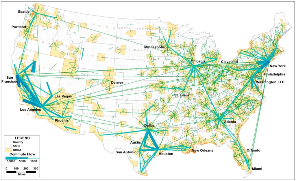
In recent decades, the emergence of megaregions has resulted in severe traffic congestion across various parts of the nation. While these expansive regional concentrations demonstrate increased mobility, there is a potential reduction in accessibility. Megaregions, exemplified in the figure below, display intricate commuting patterns within and between regions. For instance, the triangular configuration formed by Dallas, Houston, and San Antonio, with Austin in between, illustrates high commuting volumes on each edge (Zhang & Lan, 2022).
The lack of a proper response from transportation agencies and professionals to address decreased accessibility at this scale may lead to a range of negative externalities, including heightened congestion and a diminished quality of life. Among the various challenges in current urban transportation planning, road congestion stands out as a primary concern that requires ongoing monitoring and management. Initially, there was a belief among scholars that increasing transportation supply by constructing, enhancing, or extending highways would expand network capacity and address congestion. However, empirical case studies and scientific models have revealed that transportation management and policy must extend beyond this strategy. This is crucial as congestion tends to worsen with factors such as population growth, economic expansion, and other changes in the urban environment.
The potential impact of reduced property values could subsequently have adverse effects on local economies within the megaregion (Jin & Rafferty, 2018). Without appropriate intervention from transportation authorities and experts, the consequences of reduced accessibility at this scale may exacerbate existing challenges, including increased congestion, elevated costs for freight and production, and an overall decline in the quality of life. The potential repercussions on property values may further negatively influence local economies within the megaregion (Jin & Rafferty, 2018).
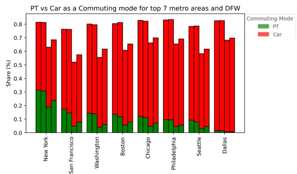
Although efforts to improve capacity and quality have led to only minor reductions in road congestion, there are policies and projects that can make a difference. For instance, better traffic signaling, designated carpool lanes, optimized transit corridors, and integrated land-use policies may help alleviate congestion. However, some experts believe that these measures have only a marginal impact and that the most effective way to reduce demand is through congestion pricing. Unfortunately, this solution is often met with public opposition. To address this issue, some countries have adopted demand management strategies such as restrictions on private car usage based on license plate numbers, parking, and road pricing (e.g., tolls, express lanes, HOV lanes), and fuel taxes. However, dependency on private cars is still very high in most urban areas within the country except for the biggest metro areas. Figure 2.9 shows the share of car commuting trips versus public transit (PT) in the first biggest 6 metro areas and Dallas -FortWorthFort Worth area. As the figure shows, there is a significant difference between the biggest metro areas and DFW (Dallas Fort Worth) region in terms of non-private vehicle usage.
Energy
Another key issue in transportation is energy, or more specifically, fuel consumption. The figure (Figure 2.7) below shows how gasoline price has changed from 1929 to 2009.
Addressing fuel consumption and its environmental impact, particularly greenhouse gas (GHG) emissions, is imperative in the context of global warming. Currently, transportation stands as the largest contributor, accounting for 28.5% of U.S. GHG emissions (Transportation Research Board & National Academies of Sciences, Engineering, and Medicine, 2018). Achieving sustainability in the transportation sector poses challenges due to the prevalence of fossil-fuel dependency, especially in subsectors like aviation, large ships, and trucks.
Moving toward sustainability involves evaluating cost-effective strategies to reduce emissions. Tasks in this endeavor include offsetting environmental consequences related to transportation activities, such as fuel mining and consumption. Initiatives are also crucial to foster private and public involvement in transitioning from fossil-fuel consumption to potentially more sustainable alternatives, like electric vehicles (EVs). Governments in many countries are actively supporting the adoption of EVs and the implementation of EV (Electric Vehicle) fueling infrastructures.
In the pursuit of sustainability, critical questions involve identifying cost-effective strategies for reducing greenhouse gas (GHG) emissions. This includes a comprehensive consideration of the environmental impact throughout the entire life cycle of transportation fuels, vehicle manufacturing, and battery components’ mining and production. Decisions also need to be made regarding the roles of the public and private sectors in facilitating the transition to both battery and hydrogen-powered electric-drive vehicles. Building public and political support for effective strategies is equally essential (Transportation Research Board & National Academies of Sciences, Engineering, and Medicine, 2018).
Research efforts in this field extend to identifying efficient ways to transition to green or low-GHG sources, understanding consumer behavior, and evaluating interactions between the public and private sectors. It is crucial to recognize that simply increasing gas prices or taxes cannot fully compensate for the environmental and societal externalities imposed on the population. Therefore, it is wise for nations and states to seek sustainable innovations to address environmental challenges. For instance, several highly industrialized nations now mandate automakers to shift their production lines from fossil-fuel cars to electric, plug-in hybrid, and hydrogen fuel-cell vehicles, prompting questions about the public’s role in fostering this transition.
Equity
Equity is a significant concern in transportation planning, encompassing issues from access to employment, healthcare, and technology across diverse population groups. Transportation professionals must consider potential barriers posed by technological advancements, especially for disadvantaged groups like low-income, uneducated, elderly, or disabled individuals. Research in transportation equity focuses on the fair distribution of benefits and burdens among different social groups, addressing challenges such as workplace accessibility, car availability, and healthcare access. Scholars emphasize the importance of ensuring that expanding transportation networks do not disproportionately impact low-income and minority neighborhoods, highlighting the ongoing challenges in addressing these issues amid evolving technology and services (Karner et al., 2020).
System Management
Maintaining and managing urban infrastructure poses challenges due to limited federal funds for highway and roadway development in the U.S. Planners must devise sophisticated strategies for system upkeep. In dynamic metro areas and regions, determining responsible organizations with appropriate administrative controls for system management is crucial. The rise of megaregions and cross-state boundaries necessitates institutional reform and enhanced cross-agency integration. Initiatives like the Chicago CREATE program, despite a $30 billion-plus project list, face funding challenges. The digital era introduces opportunities for data-driven analysis, with high-tech transportation service companies generating substantial data. However, addressing privacy concerns through data-sharing protocols is essential for cities to effectively utilize such data in managing their systems.
Goods Movement
Efficient freight movement is another crucial component of transportation planning, especially for economic well-being. Technological advancements, such as GPS-equipped trucks have facilitated easier forecasting of freight patterns. However, in many countries like the U.S., this technology is not universally implemented, requiring transportation professionals to rely on economic activity data for estimating freight movements. The expectation for faster and more convenient goods delivery, coupled with challenges like a shortage of truck drivers, the adoption of automation, and the push to reduce fossil fuel dependence, adds complexity to the currents of goods transportation. Freight movement planners must closely monitor trends like population growth, which contributes to an increased demand for goods.
As transportation planners carefully navigate the integration of newer technologies into transportation systems, it is essential to anticipate and minimize conflicts. Autonomous vehicles for instance, may bring more convenience and mobility, they may induce traffic and congestion or worsen transportation equity. Several cities are testing pilot programs in different cities to evaluate their introduction to the systems. Example cities are San Francisco, Phoenix, and Austin, who are utilizing “robotaxi” amid public safety concerns (Muller, 2023). While these technologies bring more convenience to mobility, faster deliveries, and potentially, increased safety, it is also possible that new technologies will increase the demand for the existing infrastructure. Eventually, we will face more energy consumption, emissions, congestion, or equity issues. Empirical studies show that Transportation network companies (TNCs), like Uber or Lyft, have increased mobility options for certain socio-economic groups and contributed to increased VMT, traffic congestion and emissions.
Much like other sectors, transportation is also dependent on its workforce and is facing challenges in attracting and retaining skilled workers in a competitive environment, particularly with significant salary differences between private and public sectors and emerging fields. The complex nature of the transportation sector, driven by technological advancements and increased demand, necessitates higher-skilled workers, especially in urban areas where planning intersects with IT, economics, social issues, and the environment. Outsourcing the responsibilities from the public sector to the private sector is an approach that has been practiced for decades. However, this requires a new and broader set of managerial and evaluative skills for public sector transportation planners, engineers, and managers.
There is an interconnection between workforce development and innovation in the field of transportation, enabled mostly by new technologies and higher computational and data managements capabilities such as geographic information system and science. How users respond to these new innovative approaches and emerging technologies adds another layer of complexity and uncertainty in transportation planning regarding the future of the field, anticipated trends and demands, and in general success and failure of different initiatives like transportation automation.
Conclusion
In conclusion, the history of urban form and transportation unfolds as a captivating narrative shaped by technological advancements and societal demands. From the walking cities of ancient Rome and Paris to the railway-driven expansion of London and the streetcar-enabled growth of Chicago, transportation technologies have consistently redefined the boundaries and dynamics of urban areas. The advent of affordable and convenient automobiles, along with streetcars, marked a pivotal moment in history, ushering in an era of unprecedented mobility and transformation. The proliferation of highways during the 20th century reshaped American cities into “car cities,” and the map of Atlanta in 2010 stands as a testament to the extensive impact of transportation technologies. Examining federal highway acts from the early days before World War II to the present reveals the evolution of transportation planning from a service solely for motorists to a comprehensive, bottom-up practice that addresses various issues, including safety, environment, equity, and accessibility. Reviewing the theoretical evolution of land use and transportation models highlights the limitations of aggregate, equilibrium-based models and emphasizes the development of newer techniques such as cellular automata and agent-based models at the forefront of transportation planning. In essence, a plethora of evidence underscores the continuous evolution and adaptation of transportation theories and practices, necessitating ongoing attention and innovation in the field.
Glossary
- Walking city is a city that is small enough that a person can use walking for all trip purposes.
- Industrial city is a city where the municipal economy is based on industry and residents tend to live close to factories and establishment. This type of city flourished by the advent of steam power.
- Streetcar city is a significantly bigger city than walking city in which a network of streetcar lines connects multiple parts of the city especially residential areas to suburbs.
- National System of Interstate and Defense Highway was a national plan during the presidency of Eisenhower. This plan was not just to connect different destinations inside the cities but to connect major cities across the nation.
- Environmental impact assessment is a government document in which he potential impact of actions significantly affecting the quality of the human environment is evaluated.
- Activity-based/agent-based modeling is a travel forecasting framework based on the principle that travel demand is derived from the individuals (agent) activity pattern and mobility needs.
- Compact development is type of land use development pattern that aims for efficient use of land by allocating higher density.
- Congestion pricing is pricing scheme implemented on roads that are subject to congestion to reduce the excess demand and balance it to the capacity (supply) of roads.
- Travel behavior is the study of how people move for their mobility needs and predicts travelers’ choices such as destination and mode choice.
- Suburban development or suburbanization is shift of population to peripheral areas of a city which brings urban sprawl and low-density development.
- Megaregions are generally regions that contains two or more adjacent metropolitan areas that have continuous interactions in terms of transport, economy, resources and ecology.
climate change is a shift mainly in average temperature and weather patterns as a result of human activities. - Sustainability is a concept that relates to the use of natural resources by people in a way that retains those resources for future generations as well.
- Autonomous vehicle is a self-driving car also known as driverless car that is capable of moving without human intervention.
- Transportation network companies (TNCs) refer to the ridesharing companies that match travel demand (riders) to drivers, enabled by information technology like mobile apps and websites.
- Urban sprawl is a horizontal urban development type for residential, commercial and roads that consumes a large amount of land.
- Disadvantaged groups refer to groups of people or individuals how bear a relatively higher risk of poverty, exclusion and violence compared to the general.
Key Takeaways
In this chapter we covered:
- How land use transportation relationships evolved historically.
- Transportation technologies explain a lot of urban growth patterns and distribution of activities.
- How contemporary US transportation planning practices and essential enactments, such as the Federal Highway Acts, shaped today’s transportation infrastructure.
- How evolving environmental issues and emerging new technologies may impact transportation planning practice in the coming days
- How does the transportation network affect the urban form and its evolution from a historical perspective?
- When were the development and promotion of mass transit first introduced in the US, and when did it become a common practice in transportation planning?
- What was the key theoretical issues of aggregate landuse/transportation models and how modelers have responded to such issues?
- Which concerns or issues need to be addressed to ensure a smooth transition towards sustainable transportation?
References
Affleck, F. N. (1972). The Beginnings of modern transport in France: The Seine Valley, 1820 to 1860 (Doctoral dissertation). University of London.
Batty, M. (2008). Fifty years of urban modeling: Macro-statics to micro-dynamics. In The dynamics of complex urban systems: An interdisciplinary approach (pp. 1–20). Springer.
Barrett, P. (1983). The automobile and urban transit: The formation of public policy in Chicago, 1900-1930. Temple University Press. https://www.amazon.com/Automobile-Urban-Transit-Formation-Technology/dp/0877222940
Blas, E. (2010). The Dwight D. Eisenhower National System of Interstate and Defense Highways: The road to success? The History Teacher, 44(1), 127–142. http://www.jstor.org/stable/25799401
Bogart, D. (2013b). The transportation revolution in industrializing Britain: A survey. University of California-Irvine, Department of Economics. ideas.repec.org. https://ideas.repec.org/p/irv/wpaper/121306.html
California Highways (www.cahighways.org). Telling a Story through Highway and Planning Maps: San Francisco/Bay Area Freeway Development (Part 1—The City of San Francisco). Www.cahighways.org. Retrieved April 25, 2023, from https://www.cahighways.org/maps-sf-fwy.html
Cheape, C. (1984). The Automobile and Urban Transit: The Formation of Public Policy in Chicago, 1900-1930. Temple Universitiy Press. https://books.google.com/books/about/The_Automobile_and_Urban_Transit.html?id=qBBPAAAAMAAJ
Duarte, F., & Ratti, C. (2018). The impact of autonomous vehicles on cities: A review. Journal of Urban Technology, 25(4), 3–18. https://doi.org/10.1080/10630732.2018.1493883
English, Jonathan. ( 2019, August 29). The Commuting Principle That Shaped Urban History. Bloomberg https://www.bloomberg.com/news/features/2019-08-29/the-commuting-principle-that-shaped-urban-history
Jin, J., & Rafferty, P. (2018). Externalities of auto traffic congestion growth: Evidence from the residential property values in the US Great Lakes megaregion. Journal of Transport Geography, 70, 131–140. https://doi.org/10.1016/j.jtrangeo.2018.05.022
Karner, A., London, J., Rowangould, D., & Manaugh, K. (2020). From transportation equity to transportation justice: Within, through, and beyond the state. Journal of Planning Literature, 35(4), 440–459. https://doi.org/10.1177/0885412220927691
Muller, J. (2023, August 28). Robotaxis hit the accelerator in the growing list of cities nationwide. AXIOS. https://www.axios.com/2023/08/29/cities-testing-self-driving-driverless-taxis-robotaxi-waymo
National Academies of Sciences, Engineering, and Medicine. 2018. Critical Issues in Transportation 2019. Washington, DC: The National Academies Press. https://www.nationalacademies.org/our-work/critical-issues-in-transportation
Parker, K., Horowitz, J., Brown, A., Fry, R., Cohn, O., & Igielnik, R. (2018). WHAT UNITES AND DIVIDES URBAN, SUBURBAN AND RURAL COMMUNITIES. https://www.pewresearch.org/social-trends/2018/05/22/demographic-and-economic-trends-in-urban-suburban-and-rural-communities/#:~:text=As%20a%20group%2C%20the%20population,higher%20than%20in%20the%201990s.
Vehicle Technologies Office. (2016). Fact #915: March 7, 2016 Average Historical Annual Gasoline Pump Price, 1929-2015. Retrieved from https://www.energy.gov/eere/vehicles/fact-915-march-7-2016-average-historical-annual-gasoline-pump-price-1929-2015
Weiner, E. (2016). Urban Transportation Planning in the United States. In Springer eBooks. Springer Nature. https://doi.org/10.1007/978-3-319-39975-1
Whitnah, D. R. (1998). US Department of Transportation: A reference history. Greenwood Publishing Group.
Winston, C. (2013). On the performance of the U.S. transportation system: Caution ahead. Journal of Economic Literature, 51(3), 773–824. https://www.jstor.org/stable/23644829
Walking city is a city that is small enough that a person can use walking for all trip purposes.
Industrial city is a city where the municipal economy is based on industry and residents tend to live close to factories and establishment. This type of city flourished by the advent of steam power
Streetcar city is a significantly bigger city than walking city in which a network of streetcar lines connects multiple parts of the city especially residential areas to suburbs.
National System of Interstate and Defense Highway was a national plan during the presidency of Eisenhower. This plan was not just to connect different destinations inside the cities but to connect major cities across the nation.
Environmental impact assessment is a government document in which he potential impact of actions “significantly affecting the quality of the human environment is evaluated.
Travel behavior is the study of how people move for their mobility needs and predicts travelers’ choices such as destination and mode choice.
Input-output analysis also known as (IO) is a modeling technique that disaggregates the economic activities into interactions (demand and productions) between different sectors
Suburban development or suburbanization is shift of population to peripheral areas of a city which brings urban sprawl and low-density development.
Sustainability is a concept that relates to the use of natural resources by people in a way that retains those resources for future generations as well.
Transportation network companies (TNCs) refer to the ridesharing companies that match travel demand (riders) to drivers, enabled by information technology like mobile apps and websites.
