5 Planning Roadway Networks
Chapter Overview
This chapter examines considerations in planning the multimodal roadway network. Topics include the relationship between roadway function, land use context and street design, and how modal priority and complete streets concepts may be reflected in local transportation and thoroughfare plans. The chapter draws upon advancements in context sensitive design and provides case examples from contemporary thoroughfare plans to illustrate these concepts. Related topics include the management of access, curbs and parking and their importance to multimodal planning.
Chapter Topics
- Roadway Function
- Multimodal Policy and Complete Streets
- Integrating Land Use Context
- Corridor Management Strategies
Learning Objectives
At the completion of this chapter, readers will be able to:
- Discuss the relationship between roadway function, land use context, and design
- Define the concepts of complete streets and modal priority
- Explain the importance of managing access, including curbs and parking
- Apply these concepts to a transportation plan or roadway corridor
Introduction
Roadway networks are more than just paved services for vehicular travel. They include the entire right-of-way ─ an easement that can contain many uses, such as paved lanes, medians, traffic control features, bicycle and pedestrian facilities, transitways and supporting facilities, landscaping, drainage systems and utilities. The right-of-way width ends where private property begins and determines the amount of land available to accommodate these various uses. A roadway cross section defines the different elements to be placed within the right-of-way and guides the design of that facility. Figure 5. 1 illustrates the concept of roadway right-of-way and cross section. The figure does not show utility locations, which are typically integrated along the edges of the travel way, or under paved lanes.
Each link in the roadway network has a specific planned function. This function is carried out through classification, design, and management. Some agencies prepare thoroughfare plans to establish the desired types of uses within the right-of-way and detailed strategies for implementing and managing the transportation network.
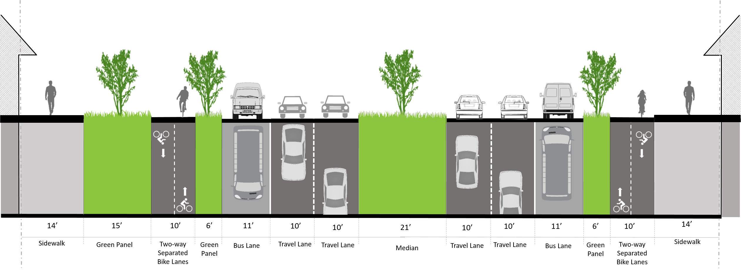
Figure 5. 1. Example of roadway right-of-way with multimodal elements.
Roadway Function
Roadways are classified in the planning process based upon their relative function in the overall transportation network. Roadways can serve a variety of functions and be categorized under various definitions and terms. One set of functions relates to the extent to which a roadway emphasizes vehicular movement, distribution, or land access. Three basic categories describe this set of functions – arterial, collector, and local. An arterial accommodates through traffic movement at relatively higher speeds and over longer distances. A local street is low speed, short in length, and provides direct access to homes and other uses. Collectors bridge the gap – distributing traffic at moderate speeds across the network between longer and higher speed arterials and local streets.
Multimodal plans may apply the three basic functional categories mentioned above, as well as a variety of others. Williams et al. (2014) explain that “[t]he number, details, and character of roadway categories will depend upon the population size, planning objectives, and complexity of the local planning area” (p. 166). Categories commonly used in transportation plans include freeways, expressways, principal/major and minor arterials, major and minor collectors, and local streets or alleys. New typologies have emerged in recent years to address non-vehicular functions more effectively, as discussed in the next sections.
Modal Priority
Modal priority refers to the relative priority placed on a given mode in the network planning process. The concept of modal priority may be integrated with the basic roadway functional categories through layers or street typologies that identify priority modes (also known as layered networks). An assigned modal priority is another factor considered in determining the design of the facility and the elements included within the right-of-way. For example:
- A bicycle boulevard places priority on bicycle travel and includes design features to discourage motor vehicle traffic, such as signs, pavement markings and safe bicycle crossings at arterials.
- A pedestrian priority street could emphasize wide sidewalks, safe crossings, and active land uses at the street level.
- A roadway with six travel lanes for motor vehicle travel and no sidewalks is giving clear priority to automobiles.
- A roadway of similar width to one with six travel lanes and that includes lanes dedicated to bus rapid transit and has sidewalks and bikeways on each side gives priority to several modes.
The Green Hierarchy is another modal priority concept advocated by groups working to reform the transportation system to make it more sustainable. It places the greatest overall priority on planning and designing the network for the pedestrian and cyclist, in light of the low cost, space efficiency and lack of adverse environmental impact of these “active” transportation modes. These active transportation modes are followed by transit, trucks, taxis and TNCs, with the lowest priority on the private automobile (Figure 5. 2).

Figure 5. 2. Green transportation hierarchy.
Layered roadway networks have been proposed as appropriate in situations where providing priority to a particular mode can improve safety and efficiency (ITE, 2011). The ITE report Planning Urban Roadway Systems (ITE, 2011, p. 2) explains the approach noting: “Well planned roadway systems should offer a variety of modal choices appropriate to the community being served and typically would include pedestrian, bicycle, transit, automobile, and truck on the same roadway network. Each of these subsystems will have its own network that overlays the others and offers the potential user choices and tradeoffs in terms of user cost, travel time, reliability, availability, safety and accessibility.”
A multimodal transportation plan could identify roadways by functional classification and the degree of priority placed on non-automobile modes. These layers would each include pedestrian facilities mapped as a series of “overlays,” such as:
- Roadway Classification: major arterial, minor arterial, collector, local
- Transit: transit priority streets
- Bicycle: bicycle priority streets
- Truck: truck routes
For example, the City of Seattle’s Policy Framework for Integrating Walking, Biking, Transit, and Freight (City of Seattle, 2021) prioritizes travel modes based on connections to Urban Village, Urban Center, and Manufacturing/Industrial Centers. A series of priority functions are identified for the rights-of-way that connect these centers, including storage, greening, activation, access for commerce, access for people, and mobility. Pedestrians are prioritized in urban villages and centers, goods movement is prioritized in manufacturing and industrial centers, and transit is prioritized between urban villages and centers, with the bicycle network the priority at all critical connections citywide.
5.2.2 Context Sensitive Roadway Typologies
The context sensitive solutions (CSS) approach emerged in the late 1990s in response to the lack of consideration of land use context in conventional street design. As with complete streets policies and guidelines and the green hierarchy concept, a goal of CSS is to reduce the dominance of vehicular capacity in roadway design decisions. The CSS approach aims to provide flexibility in design to shape solutions to transportation problems that are compatible with the surrounding context and the needs and desires of stakeholders.
CSS has introduced a number of new functional categories or “typologies” that more explicitly consider the pedestrian. CSS provides additional guidance to street design and modal priority in varying land use contexts. The Institute of Transportation Engineers Recommended Practice, Designing Walkable Urban Thoroughfares: A Context Sensitive Approach (ITE/CNU, 2010) suggests use of the categories parkway, boulevard, avenue, street, and alley/lane. Each functional category in a multimodal plan is described to clarify its planned functions and provide additional guidance for design and modal priorities.
Multimodal Policy and Complete Streets
Many communities are adopting multimodal policies to ensure that roadways are designed for all users and not just automobiles. There are a variety of different types of policies in a multimodal plan to accomplish this goal. One of the more widely known relates to “complete streets.” As summarized by Wikipedia, “Complete streets is a transportation policy and design approach that requires streets to be planned, designed, operated and maintained to enable safe, convenient and comfortable travel and access for users of all ages and abilities regardless of their mode of transportation” (para. 1).
Complete Streets Policy
The national Complete Streets Coalition identified elements of an ideal Complete Streets policy in consultation with stakeholders and professionals across the nation. The goal was to establish a national model of best practices to guide development and implementation of these policies. These elements of an ideal complete street policy identified in the report are as follows (Smart Growth America, 2018):
Elements of an Ideal Complete Streets Policy
-
Vision and intent: Includes an equitable vision for how and why the community wants to complete its streets. Specifies need to create complete, connected, network and specifies at least four modes, two of which must be biking or walking.
-
Diverse users: Benefits all users equitably, particularly vulnerable users and the most underinvested and underserved communities.
-
Commitment in all projects and phases: Applies to new, retrofit/reconstruction, maintenance, and ongoing projects.
-
Clear, accountable exceptions: Makes any exceptions specific and sets a clear procedure that requires high-level approval and public notice prior to exceptions being granted.
-
Jurisdiction: Requires interagency coordination between government departments and partner agencies on Complete Streets.
-
Design: Directs the use of the latest and best design criteria and guidelines and sets a time frame for their implementation.
-
Land use and context sensitivity: Considers the surrounding community’s current and expected land use and transportation needs.
-
Performance measures: Establishes performance standards that are specific, equitable, and available to the public.
-
Project selection criteria: Provides specific criteria to encourage funding prioritization for Complete Streets implementation.
-
Implementation steps: Includes specific next steps for implementation of the policy.
Source: Smart Growth America, 2018
Integrating Land Use Context
A defining characteristic of contemporary multimodal planning is the conscious integration of land use and transportation planning. The leading example is that of the CSS approach, which seeks to achieve a balance between planned roadway functions and roadside land use context. Context zones are identified based on a transect to orient roadway types and design to specific land use patterns, as proposed in the ITE Recommended Practice, Designing Walkable Urban Thoroughfares: A Context Sensitive Approach (ITE, 2010). This approach places greater emphasis on non-auto modes than conventional design. Some local governments complement this strategy with “form-based” development codes that integrate building design and layout with street design.
Basic elements of the approach are as follows (ITE, 2010):
- Seven context zones are defined to correspond to a transect (Figure 5. 3) that categorizes land use contexts according to character, density of activities and intensity of development, ranging from “natural” to “urban core” or “special district”.
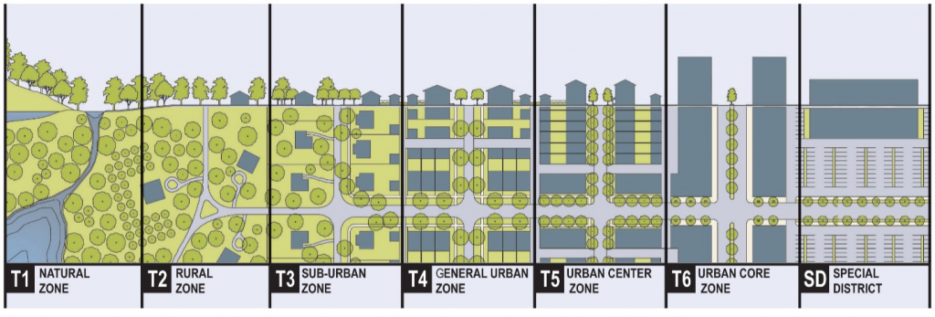
Figure 5. 3. Rural-urban transect
- Thoroughfares are categorized by function and type as discussed previously and design characteristics are tailored to the roadside context for each segment. The thoroughfare type is governed by design elements and features that fit within a particular context, such as sidewalks, planting strips, medians, bike lanes, on-street parking, and access location.
- The context zone and community vision are matched to desired characteristics for a thoroughfare. This may result in tradeoffs between automobile capacity and multimodal design elements.
The practice of “context sensitive solutions” (CSS) and the designation of context zones helps describe the physical form and characteristics of a place and can be interpreted on a block-by-block basis for thoroughfare design. This approach has led to many variations that are tailored to each area’s unique vision, goals, and characteristics. Some areas use broad area types to guide the design of the transportation network, whereas others use specific types similar to the transect. Below are some examples:
- The City of El Paso, Texas applies three basic area types in its thoroughfare plan: Compact Urban, Drivable Suburban and Rural. They also utilize a number of subcategories within each area type to identify its various planning areas.
- Indianapolis-Marion County, Indiana uses two broad area types in its thoroughfare plan: Compact and Metropolitan.
- The City of Bastrop, Texas uses seven Place Types similar to transect zones to guide the design and development of its street network: P1 – Nature, P2 – Rural, P3 – Neighborhood, P4 – Neighborhood Mix, P5 – Core, EC – Employment Center, CS – Civic Space, and PDD – Planned Development District.
Case Examples
Indianapolis-Marion-County, Indiana
The Indianapolis-Marion County Thoroughfare Plan is part of the comprehensive plan and covers goals, existing plans, functional classification, right-of-way preservation, and plan implementation guidelines. The Thoroughfare Plan prioritizes transit, pedestrians, freight, and bicycles and implements Complete Streets by ensuring all modes are accommodated on the transportation system. The plan notes that right-of-way needs are incorporated for all modes, along with guidance on how to address conflicts among the various modal priorities and design guidance on multimodal facilities.
Roadways are classified by function, context (Compact or Metropolitan), and number of lanes. Additionally, the Thoroughfare Plan provides a means to establish priorities for users of the right-of-way. Compact context areas are characterized as having higher density development, structures placed closer to the right-of-way and to one another, and possibly street grid networks. Metropolitan context areas are defined as including moderate to rural density development, suburban development patterns, building set back from rights-of-way, and possibly cul-de-sacs and curvilinear street systems.
Road types for functional classification in the plan include Freeway/Expressway/Highway (Thoroughfares), Primary Arterial (Thoroughfares), Secondary Arterial (Thoroughfares), Primary Collector (Non-Thoroughfares), Secondary Collector (Non-Thoroughfares), Local Street (Non-Thoroughfares), and Special Corridors (Non-Thoroughfares). Each roadway type is defined in text to clarify the planned function, speeds, volume, and related modal characteristics. Special corridors are rights-of-way required for unique circumstances, policy objectives, or facility types such as the Belt-Line Railroad Corridor and Greenway Corridors, which accommodate designated off-street greenway trails or shared-use paths.
The ROW Standards and Design Guidelines Table of the Thoroughfare Plan is used as a preliminary tool for determining which roadway elements and users are prioritized for each roadway functional classification and context area. It specifies the minimum and maximum right-of-way width based on speed limit and desired cross section elements. These elements include the following:
- Streetside elements: transition/grading utility, sidewalk, transit/bus shelter, shared-use path, landscape buffer
- Separated bike elements: protected bike lane, buffered bike lane
- On-street elements: bike lane, sharrow (share the road arrow in the form of a bicycle used to identify bicycleways), curb and gutter/shoulder, on-street parking/bump-out, travel lane
A section on proposed right-of-way explains the basis for the minimum right of way widths to be preserved. The thoroughfare system is also mapped, with roadway classifications guiding right-of-way needs and other requirements, such as building setbacks and sight lines.
Fort Worth, Texas
The City of Fort Worth Master Thoroughfare Plan (MTP) provides detailed long-range guidance for the development of the thoroughfare network based on a “Complete Streets” philosophy. The emphasis is on connectivity, accessibility, safety, and comfort for walking and cycling. It is a regulatory plan that is implemented through the planning, development review, and capital improvement process. The MTP establishes and maps a number of street types and each thoroughfare undergoes an analysis to determine its unique right-of-way needs. The analysis involves assessing the number of lanes, the type of special transit facilities required, the type of median needed, the type of parking, and the type of bike facilities needed for the given street type.
Four maps are used as inputs for this selection process: the Street Type Map, the Lanes Map, the Bicycle Network Map, and the Transit Vision: Major Services Map. Additional inputs include quantitative data about the thoroughfare and any special corridor designations, such as Roundabout Corridor, Aesthetic Corridor, and Special Residential Section. Street types are determined by evaluating each street’s respective land-use context and the various transportation modes prioritized for that street type. The five street types are: Activity Streets, Commerce/Mixed-Use Streets, Neighborhood Connectors, Commercial Connectors, and System Links, as described in Table 5.1. Because land use context is considered in street type, the plan does not apply separate area types or context zones.
Table 5.1. City of Fort Worth Street Type Descriptions
| Street Type | Description |
|---|---|
| Activity Street | Activity Streets are “destination streets”. They are typically retail-oriented, with generous parkway widths and room for sidewalk cafes and other such features. Automobile speeds are slow, and lanes are slightly narrower than typical. Parking is typically on-street, and building facades front the street. Buildings are typically one to three stories high. Streets are typically in a grid pattern, diffusing traffic. People bicycling may share the road depending on speeds, but bike lanes may also be provided. |
| Commerce/Mixed-Use Street | Commerce/Mixed-Use Streets have a business flavor and can often be found downtown. Buildings are typically multi-storied and are often office/commercial oriented, but may have residential uses on the upper floors. Buildings front on the street and on-street parking is common, but parking garages are also common – meaning automobiles are often turning to and from the street. Wide sidewalks are prevalent and are especially busy during rush hours and the lunch hour. Streets are typically in a grid pattern, diffusing traffic. Commuter transit is prevalent, and traffic speeds are fairly slow. Automobile lanes are slightly narrower than typical. Bike lanes are often provided. |
| Neighborhood Connector | Neighborhood Connectors provide access from neighborhoods to services. They often run at the peripheries or within residential areas, and landscaped medians are fairly common. Sidewalks or multi-use paths are typically separated from the street by a landscape buffer. Buildings (or residential fences) are generally set well back from the street. Automobile speeds are moderate. |
| Commercial Connector | Commercial Connectors typically serve retail and industrial portions of the City. Many driveways may be present, and a mixture of medians and center turn lanes help to regulate movements to and from sites. Retail stores are often separated from the street by surface parking lots. Automobile speeds are moderate to high. Bicycle facilities must be carefully designed due to the higher density of driveways. Sidewalks are buffered from the street by landscaping. |
| System Links | System Links emphasize longer-distance automobile traffic, often providing connections to freeways or other regional transportation networks. Automobile speeds are moderate to high. Pedestrians and bicyclists are buffered from traffic as much as possible; multi-use off-street paths are common and no on-street bike lanes are provided. System Links always include raised medians to separate traffic directions and facilitate left turns. Most left turns occur at signalized intersections; access to driveways is typically via right turns. |
Source: City of Fort Worth, 2020
When the Typical Section Selection process is complete, each element is coded and the corresponding minimum widths for that code results in an implied right-of-way width. This information, along with target vehicle speeds and other corridor characteristics, such as flex space and buffers, is used to select an appropriate cross-section from a suite of cross-sections that are associated with each street type.
As a regulatory document, the Fort Worth Master Thoroughfare Plan includes a clear explanation of the process for changes and exceptions. This consists of full updates, amendments to segments between full updates, waivers for slight deviations, and street type exceptions. Additionally, waivers are provided for interim cross sections for certain situations in which constructing the full cross section dictated by the Master Thoroughfare Plan would be infeasible or cost prohibitive. This type of waiver must include a plan to transition to the adopted cross section and demonstrate that safety and connectivity will not be negatively affected. Certain types of amendments and waivers can be handled administratively by city staff while others require City Plan Commission Approval.
*
Corridor Management Strategies
This section introduces some additional methods for managing multimodal roadway corridors relative to their planned functions. These strategies are the management of access, curb use, and parking.
- Access management involves the coordinated planning, regulation, and design of access between roadways and land development. It is important to the safety and efficient operation of the major roadway network for all modes.
- Curb management relates to a variety of techniques for allocating use of curb space in urban areas for the many competing uses, such as loading and unloading of freight or passengers.
- Parking management refers to a variety of policies, programs, and strategies to make efficient use of parking resources, while accommodating other modal needs and furthering community goals.
Access Management
Access management involves the coordinated planning, regulation, and design of access between roadways and land development (Williams et al., 2014). “Careful control of access along major roadway corridors reduces traffic conflicts and flow interruptions, while improving safety for drivers, pedestrians, and bicyclists” (Williams et al, 2014, p. 109). A central objective of access management is the management of conflict points among the different users of the transportation system. As conflict points increase, so does the potential for crashes. Research demonstrates that drivers are more likely to have collisions with each other and with pedestrians and cyclists when navigating complex driving situations with numerous potential conflicts. Figure 5. 4 illustrates this concept.
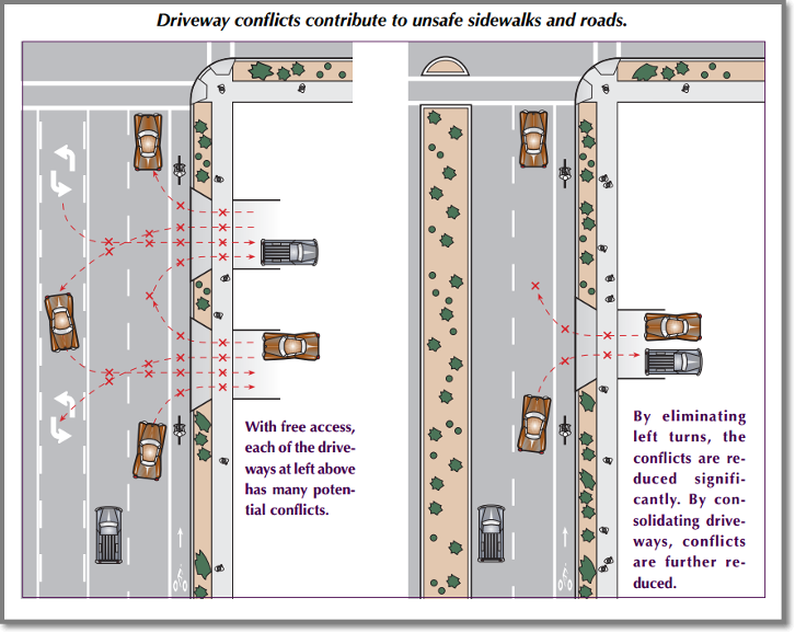
Figure 5. 4. Effect of access management on exposure to conflicts.
Access between roadways and land development may be managed through a variety of planning, policy, design, and regulatory techniques. Some examples of access management techniques are (Pande et al., 2015; Williams, 2020):
- Limiting and separating driveways along major roadways through access spacing standards.
- Use of median treatments to limit left turns to planned locations and provide mid-block pedestrian crossings on busy roads.
- Locating traffic signals to support signal coordination and efficient traffic progression.
- Providing right- and left-turn deceleration and storage lanes to remove turning vehicles from through lanes.
- Restricting driveways in the vicinity of signalized intersections and interchanges to reduce the potential for conflicts and crashes.
- Providing internal bus transit access to certain developments and the careful location and design of transit access to minimize modal conflicts.
- Providing direct sidewalk connections to transit and safe mid-block crossing locations.
- Measures to reduce on-site circulation conflicts between pedestrians and motor vehicles, such as striped walkways, crosswalks and other treatments.
- Requiring pedestrian and vehicular connections between adjacent businesses to allow circulation between sites without reentering busy roads.
- Providing direct paths between commercial centers and abutting residential developments.
- Promoting mixed-use activity centers with unified on-site circulation and access and discouraging commercial strip development with closely spaced driveways.
- Requiring land uses to be organized on city blocks or dense connected networks and restricting driveways and off-site parking along curb frontage.
Roadway function, existing and planned land use context, and modal priority are all integral to determining appropriate access management strategies and standards (Williams, 2020). For example, fronting buildings on the street is preferred in urban core areas and on pedestrian or transit priority routes as it provides easy pedestrian access from the sidewalk to the building. City blocks in the urban core are reinforced to improve pedestrian accessibility and reduce the need for driveway access. In suburban areas, driveway spacing standards help avoid closely spaced driveways – a common problem of commercial strip development. Adjacent properties may be required to connect parking lots and share driveways.
From a programmatic perspective, access management standards may be identified and assigned to roadways using functional classification and context classification, or via a separate access classification system (Williams, 2020). A separate access classification system has the benefit of allowing the assignment of different access management standards to roadways of the same functional classification but having different design characteristics and functional needs (Williams et al., 2014). Some local governments also adopt special forms of zoning, such as form-based codes or transit oriented development districts that include specific access design provisions.
Case Examples
Model access management regulations prepared for local governments in Florida propose a three-category access classification scheme with broad descriptions for statewide application. The descriptions and corresponding standards are designed for relative consistency with the access management standards and context classifications used by the Florida Department of Transportation for the state highway system and are as follows (Williams and Barber, 2017):
- Category A (FDOT Access Class 2): These are highly access-controlled roadways that function as principal arterials and have the greatest continuity in the thoroughfare system. Direct access to abutting land is controlled to preserve safe and efficient through traffic movement. Posted speeds are typically 45 mph or greater. They shall include existing or planned restrictive medians, but some sections may have alternating painted left-turn lanes or be undivided. This Access Category provides the greatest separation between connections and traffic signals. It applies to controlled access Strategic Intermodal System (SIS) roadways, and designated arterials in rural, less developed or suburban areas (e.g., FDOT context classification C1, C2, C3R, C3C). The street network along these roadways shall be planned to support access to development and signal locations will be carefully managed to maintain efficient traffic progression.
- Category B (FDOT Access Class 3, 4): These roadways support mobility within and across urban areas and typically have somewhat less continuity and/or operate at lower speeds than Access Category A roadways. They should include existing or planned restrictive medians, but some sections may have alternating painted left-turn lanes or be undivided. Separation between connections is less than that required for Category A but is still sufficiently controlled to create a safe environment for vehicular and non-vehicular travel modes. This Category generally applies to both arterial and collector roadways that lie outside the urban core (e.g., FDOT context classification C5, C4, C3R, C3C, C2T) or similarly developed neighborhoods.
- Category C (FDOT Access Class 5, 6): These roadways support mobility in dense urban contexts and operate at lower speeds. Driveway connections may be discouraged in favor of block patterns. Control of access is the least restrictive due to lower speeds and to accommodate compact development. Access Category C generally applies to segments of the thoroughfare system within denser urban areas that often have higher levels of non-auto traffic and community activity (e.g., FDOT context classification C2T, C4, C5, C6), including segments designated as pedestrian or transit priority streets.
The model category system defers to existing or planned city block spacing on lower speed Class B or C roadways [see Table 5. 2].
| Access Category | Connection Spacing | Median Opening Spacing (1) (ft) | |
|---|---|---|---|
| >45 mph | ≤45 mph | Full Movement | |
| A | 1320 | 660 | 1320(2)/2640 |
| B | 660 | 440(3) | 1320(2)/2640 |
| C | NA | 245(3) | 660(3) |
(1) Applies to full movement median openings where a “restrictive” (nontraversable) median is present that physically prevents vehicle crossing. Full openings could potentially be signalized in the future and spacing should be maintained for progression and signal coordination. Greater distances may be required to provide for sufficient turn lane storage. Directional median openings may be allowed at any location on the roadway where the (city/county) engineer determines that U-turns or left-turn movements can be safely accommodated.
(2) For roads with posted speed limits ≤45mph.
(3) Or per existing block spacing or block spacing as identified in the local comprehensive plan or an approved development plan. Densely developed areas with a block pattern that accommodates community activities, bicyclists, and pedestrians should not have posted speeds higher than 35 mph.
Source: Williams and Barber, 2017.
Note: The latest version of the FDOT Access Management Manual and FDOT Multimodal Access Management Manual are available online and can be accessed for the latest version of the access management standards on Florida.
*
Curb Management
Historically, curb space in urban areas has been allocated for a limited number of uses, such as on-street parking, taxis, or truck deliveries. Today, many different uses join these to vie for use of curb space, such as TNCs (e.g., Uber, Lyft), e-commerce deliveries, electric vehicle charging, bike share infrastructure, emergency services, mobile vendors, pedestrians (pick-up and drop off zones), parklets, streetscaping, outdoor seating for businesses, and transit infrastructure. In addition, the curb is a potential revenue source not only for parking fees, but many other new uses. Conflicts among these uses and the potential for revenue, have led to a growing practice known as curb management.
The Institute of Transportation Engineers Complete Streets Council published the Curbside Management Practitioners Guide (ITE, 2018) offering guidance on optimizing the use of curb space in this increasingly competitive environment. This guide reframes the curb as dynamic, rather than fixed infrastructure, requiring a flexible approach to management and a clear understanding of the potential functions of the public right-of-way.
An example may be found in the City of Seattle, which identifies curb space as a flex zone with a variety of potential functions (Figure 5. 5). Seattle further identifies and defines six essential functions of the overall public right-of-way as mobility, access for people, access for commerce, activation (e.g., parklets, sidewalk cafes, festivals), greening (e.g., rain gardens, street trees), and storage (e.g., bus layover spaces, emergency vehicles, parking) (City of Seattle, 2021).
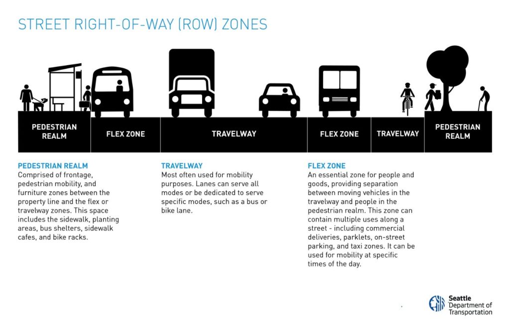
Figure 5. 5. Example right-of-way function designations in the City of Seattle for planning purposes.
Failure to organize these different functions can increase conflicts or friction among the various street users and result in a number of safety and operational problems. For example, a TNC may stop in the through lane to allow a passenger to disembark, blocking buses and other through traffic. The National Association of City and Transportation Officials (NACTO, 2017) produced the guide, Curb Appeal, offering guidance on curbside management for transit reliability through strategies noted in Table 5. 3.
| Strategy | Description |
|---|---|
| Shifting from Parking Lane to Flex Zone | Flex zones can be designated to serve multiple functions simultaneously, different functions at specific times, or multiple functions in different spaces. |
| Clearing the Way for Transit | Reduce curbside parking, make room for transit at peak periods, and accommodate transit priority features, such as queue jump lanes, turn pockets or approach lanes that clear cars from the transit lane. |
| Moving Loading and Access Nearby | Reduce blockage of bus lanes by reserving main streets for short term uses and assigning longer times at the curb a feasible distance from destinations. Strategies include time limits, demand-based pricing, occupancy targets, fines and automated enforcement. |
| Looking Beyond the Corridor | Manage curbside use at a neighborhood scale to provide space to reassign parking locations as well as curbside access. Examples include replacing on-street parking with shared parking nearby. |
Synthesized from NACTO, 2017.
Parking Management
Parking management refers to a variety of policies, programs and strategies to make efficient use of parking resources, while accommodating other modal needs and furthering community goals (Litman, 2021). A detailed summary of these strategies may be found online in Litman (2021) Parking Management: Strategies, evaluation, and planning.
An excessive supply of parking encourages single occupancy vehicle use and discourages active transportation. For example, the large continuous areas of pavement synonymous with contemporary parking lots are not appealing to pedestrians because they typically increase the length of the pedestrian trip (Williams and Seggerman, 2014). Parking limits and other parking management strategies are found to have positive effects on active transportation modes with improved safety and convenience for bicyclists and pedestrians. These strategies also support transit with compact development and increases the density and diversity of land use activities. Strategies may include parking duration limits, time-of-day limits, restricted parking zones, parking maximums, shared use parking, increasing the capacity of existing parking facilities, remote parking with shuttle services, and pricing (Litman, 2021; Williams and Seggerman, 2014).
An issue in conventional planning practice has been the tendency to overstate parking needs in local ordinances. The Institute of Transportation Engineers Parking Generation Manual, the basis for most local parking requirements, has been widely critiqued for its overly generous yet precise estimates of parking needs based on limited samples in suburban areas. Shoup (2003) explains how this leads to a six-step cycle of planning for free parking that reinforces auto-oriented sprawl development.
*
Shoup’s 6-Step Cycle of Planning for Free Parking
“Step 1. Transportation engineers survey the peak parking demand at a few suburban sites with ample free parking but no transit service, and ITE publishes the results in Parking Generation with misleading precision.
Step 2. Urban planners consult Parking Generation to set minimum parking requirements. The maximum observed parking demand thus becomes the minimum required parking supply
Step 3. Developers provide all the parking that planners require, and the ample supply of parking drives the price of most parking to zero, which increases vehicle travel.
Step 4. Transportation engineers survey vehicle trips to and from suburban sites with ample free parking but no transit service, and ITE publishes the results in Trip Generation with misleading precision.
Step 5. Transportation planners consult Trip Generation as a guide to design the transportation system with adequate capacity to bring cars to the free parking.
Step 6. Urban planners limit density so that development with ample free parking will not generate more vehicle trips than nearby roads can carry. This lower density spreads activities farther apart, further increasing both vehicle travel and parking demand.”
Shoup, 2003
As a result, many cities have abolished minimum parking requirements citywide or in specific districts, often replacing them with maximum parking requirements to support higher density development. The Metropolitan Area Planning Council in the Boston, Massachusetts metropolitan area produced a sustainable transportation parking toolkit that identifies many examples (MAPC, 2011). The toolkit notes that for flexibility, parking rights for developments that need less parking can be transferred and sold from one development to another that may need more parking (MAPC, 2011).
Another parking management strategy is to unbundle the cost of parking from that of rent. Doing so allows cheaper rents for residents in dense urban areas with robust modal options to forego parking if they don’t want to own a car. Less parking reinforces use of transit and other modes. A study of overnight residential parking in 14 municipalities by the Metropolitan Area Planning Council in Boston found that three out of ten spaces sit empty during peak demand periods, increasing construction costs an average of $5000 per housing unit (MAPC, 2019). These increased costs of housing are then borne by the consumer who pays higher rents.
Modern technology is increasingly allowing for dynamic management of parking to optimize parking usage while also influencing travel behavior. This is known as active parking management and can affect travel demand by influencing trip timing, mode choice, and choice of where to park (USDOT, Active Parking Management website). Examples include use of technology to dynamically vary pricing based on demand and availability of parking, offer real-time information on parking spaces available in an area, or allow a traveler to reserve a parking space in advance.
*
Key Takeaways
Roadway network planning has become increasingly multimodal. Traditional roadway types and functions are being redefined to accommodate this change in practice and roadway cross sections are being planned with a greater variety of modal elements. Key takeaways from this chapter are:
- Roadways are more than just paved services for vehicular travel. They include the entire right-of-way ─ an easement that can contain many uses such as paved lanes, medians, traffic control features, bicycle and pedestrian facilities, transitways and supporting facilities, landscaping, drainage systems and utilities.
- A roadway cross section defines the different elements to be placed within the right-of-way and guides the design of that facility.
- Each link in the roadway network has a specific planned function. This function is carried out through classification, design, and management.
- An assigned modal priority is a factor considered in determining the design of the facility and the elements included within the right-of-way.
- A multimodal transportation plan could identify roadways by functional classification and the degree of priority placed on non-automobile modes.
- The context sensitive solutions (CSS) approach was advanced to help overcome limitations of conventional functional classification for street design.
- Many communities are adopting multimodal and complete streets policies in an effort to ensure that roadways are designed for all users and not just automobiles.
- A defining characteristic of contemporary multimodal planning is the conscious integration of land use and transportation planning. The leading example is that of the CSS approach, which seeks to achieve a balance between or ideally to integrate planned roadway functions and roadside land use context.
- Some agencies prepare thoroughfare plans to establish the desired types of uses within the right-of-way and detailed strategies for implementing and managing the transportation network. Contemporary thoroughfare plans may use broad area types to guide the design of the transportation network, whereas others use specific types similar to the CSS transect.
- Additional methods for managing multimodal roadway corridors are access management, curb use management, and parking management.
*
Self Test
*
Glossary
Access Management: The coordinated planning, regulation, and design of access between roadways and land development.
Arterial: A roadway that accommodates through traffic movement at relatively higher speeds and over longer distances.
Collector: A roadway that distributes traffic at moderate speeds across the network between longer and higher speed arterials and local streets.
Curb Management: A variety of techniques for allocating use of curb space in urban areas for the many competing uses.
Green Hierarchy: A modal priority concept that places the greatest overall priority on planning and designing the network for the pedestrian and cyclist, in light of the low cost, space efficiency and lack of adverse environmental impact of these “active” transportation modes.
Local Street: A roadway that is low speed, short in length, and provides direct access to homes and other uses.
Modal Priority: The relative priority placed on a given mode in the network planning process.
Parking Management: A variety of policies, programs and strategies to make efficient use of parking resources, while accommodating other modal needs and furthering community goals.
Right-of-Way: An easement that can contain many uses, such as paved lanes, medians, traffic control features, bicycle and pedestrian facilities, transitways and supporting facilities, landscaping, drainage systems and utilities.
*
References
Broward County Complete Streets Guidelines (October 2013). Broward Metropolitan Planning Organization.
City of Charlotte, North Carolina. (2019). Zoning ordinance: Chapter 15, transit oriented development districts.
City of Fort Worth. (2020). City of Fort Worth Texas: Master thoroughfare plan (2020 update). https://www.fortworthtexas.gov/files/assets/public/tpw/documents/adopted-mtp-nov-10-2020-reduced.pdf
City of Seattle. (2016). Seattle right-of-way improvements manual. https://streetsillustrated.seattle.gov/street-type-standards/row-allocation/
City of Seattle. (2021). Update on the modal integration policy framework. https://www.seattle.gov/Documents/Departments/SDOT/BikeProgram/SBAB/Modal%20Integration%20Policy%20Framework.pdf
Duany Plater-Zyberk & Company. (n.d.). Rural-urban transect. https://transect.org/rural_img.html
Institute of Transportation Engineers/Congress for the New Urbanism. (2010). Designing walkable urban thoroughfares: A context sensitive approach (An ITE Recommended Practice). Washington, D.C.: ITE, 2010. Accessed online: https://www.ite.org/pub/?id=e1cff43c%2D2354%2Dd714%2D51d9%2Dd82b39d4dbad
Institute of Transportation Engineers. (2011). Planning roadway systems: An ITE recommended practice. Washington, D.C.
Kimley Horn and Associates, Inc. (2013) Broward County complete streets guidelines: Providing guidance for developing safer and healthier streets accommodating all users. http://archive.browardmpo.org/projects-studies/complete-streets/guidelines
Litman, T. (2021) Parking Management: Strategies, evaluation and planning. Victoria Transport Policy Institute.
Metropolitan Area Planning Council (MAPC). (2019). Perfect fit parking. Boston, MA https://perfectfitparking.mapc.org/
Metropolitan Area Planning Council (MAPC). (2011). Sustainable transportation: Parking toolkit, Boston, MA. Accessed online: https://www.mapc.org/resource-library/sustainable-transportation-parking-toolkit/
Montgomery County, Maryland. (April 2019). Veirs Mill Road corridor master plan. Accessed online: https://montgomeryplanning.org/wp-content/uploads/2020/01/Veirs-Mill-Corridor-Master-Plan-Approved-and-Adopted-WEB.pdf
NACTO. (2017). Curb appeal: Curbside management strategies for improving transit reliability. Accessed online: https://nacto.org/wp-content/uploads/2017/11/NACTO-Curb-Appeal-Curbside-Management.pdf
Orange County, Florida. (2017). I-Drive District overlay zone. Division 4.5/Ordinance No. 2017-03 Sec. 38-861. http://www.ocfl.net/portals/0/Library/Board%20Of%20County%20Commissioners/docs/I-DriveDistrictZone3162020FINAL-CERT.pdf
Oregon Transportation and Growth Management Program. (1999). Main Street…when a highway runs through it: A handbook for Oregon communities, Salem, Oregon. https://nacto.org/wp-content/uploads/2015/04/mainstreethandbook.pdf
Porter, J., Lee, J., Davis, M., Bryan, S., Corso, P., & Rathbun, S. (2019). Complete streets state laws & provisions: An analysis of legislative content and the state policy landscape, 1972–2018. Journal of Transport and Land Use, 12(1), 619-635. Retrieved June 17, 2021, from https://www.jstor.org/stable/26911281
Shoup, D. (2003). Truth in transportation planning. Journal of Transportation and Statistics. Vol 6, No 1. http://www.bts.gov/publications/journal_of_transportation_and_statistics/
Smart Growth America. (2018). The elements of a complete streets policy. National Complete Streets Coalition. https://smartgrowthamerica.org/resources/elements-complete-streets-policy/
USDOT. Active transportation and demand management: Active parking management. Accessed online 9/23/2021 https://ops.fhwa.dot.gov/atdm/approaches/apm.htm
Williams, K. (2020). NCHRP synthesis 549: Incorporating roadway access management into local ordinances, Washington D.C.: Transportation Research Board of the National Academies.
Williams K. and J. Barber. (2017). Model access management policies and regulations for Florida cities and counties, 2nd Edition. Center for Urban Transportation Research. https://www.cutr.usf.edu/wp-content/uploads/2018/01/Model-Regulations-Final-Report.pdf
Williams, K., V.G. Stover, K. Dixon, P. Demosthenes, F. Broen, L. Brown, D. Huntington, R. Layton, and K. Seggerman. (2014). Access management manual, 2nd Edition. Washington D.C.: Transportation Research Board of the National Academies.
Wikimedia Commons. (n.d.). Green transport hierarchy pictogram. https://commons.wikimedia.org/wiki/File:Green-transport-hierarchy-pictogram.svg
Further Reading
Hillsborough County City-County Planning Commission. (May 2016). best practices in parking management. https://planhillsborough.org/wp-content/uploads/2016/05/Parking-Best-Practices-FINAL.pdf
City of Burlington, Vermont. Residential parking management plan. https://www.burlingtonvt.gov/sites/default/files/DPW/Publications/ResidentialParkingPlan_final.pdf
A roadway that accommodates through traffic movement at relatively higher speeds and over longer distances.
A roadway that distributes traffic at moderate speeds across the network between longer and higher speed arterials and local streets.
A roadway that is low speed, short in length, and provides direct access to homes and other uses.
A modal priority concept that places the greatest overall priority on planning and designing the network for the pedestrian and cyclist, in light of the low cost, space efficiency and lack of adverse environmental impact of these “active” transportation modes.
An easement that can contain many uses, such as paved lanes, medians, traffic control features, bicycle and pedestrian facilities, transitways and supporting facilities, landscaping, drainage systems and utilities
