11 Geography and Geographical Information Systems (GIS)
What is Geography?
The word geography is believed to have been coined by the ancient Greek scholar Eratosthenes (276 BCE–194 BCE), who combined the words “geo” – Earth – and “graphia” – description – to explain an important goal of many intellectuals of the classical world. This goal of describing the Earth by mapping the known world, explaining weather and climate, estimating the size and shape of the planet, and theorizing about the relationship between humans and their environment was pursued across the ancient world. Influences on geographical thought and practice can be attributed to Herodotus’ (484 BCE-425 BCE) chronicle of events, regions and cultures, Euclid’s (300 BCE-200 BCE) geometry, Strabo’s (63 BCE-23 CE) poetic impressions of place, Ptolemy’s (100-170) geographical coordinate system, and Al-Idrisi’s (1100-1165) cartographical calligraphy of the known world’s climatic zones.
Mapmaking advanced significantly during the 7th to 12th centuries as Arab and Persian cartographers sought to map the world using sophisticated mathematics and knowledge gained from Muslim travelers and traders. Further advancements in cartography emerged in the 16th century as European powers sought better maps for ocean navigation and descriptions of the Americas. The professionalization of the discipline of geography occurred in early nineteenth century Europe as geographical societies were formed and German geographers, especially Alexander von Humboldt and Carl Ritter, proposed theories of nature and society. Most European geographers remained focused on theorizing throughout the nineteenth and twentieth centuries, while North American geographers, until the mid-twentieth century, preferred to pursue practical knowledge and description. Since the mid-twentieth century, the discipline of geography has both grown and splintered. Geographers today study a plethora of topics using a wide spectrum of methods and theories.[1]
Physical Geography, Human Geography, and Research in Geography
One of the artificial cleavages in the discipline of geography is between the sub-fields of physical geography and human geography. While physical geographers focus on the spatial processes associated with the natural environment, such as climate, water, plants, animals, and landforms, human geographers investigate the spatial relationships apparent in human activities and phenomena – politics, economics, culture, migration, and history. Fortunately, some geographers today have begun to reunite the field as it becomes increasingly clear that topics such as climate change, disease pandemics, urbanization, and globalization require multidisciplinary and integrated perspectives from the sciences, humanities, arts, and social sciences. The move toward integrative and cross-disciplinary research is aided by the variety of research methods that have been developed by geographers since the early twentieth century.[2]
Geographical data can take the form of just about anything that can be paired with a location. Geographers collect data in the form of physical measurements (e.g., coordinates, distance, size, volume, temperature, elevation, velocity, morphology), observations through field study, surveys, interviews, archival documents, government agency reports, historical maps, and so on. The analysis of geographical data is accomplished through quantitative, qualitative, and mixed-methods approaches. The emergence of computers, and an interest in making geography more scientific, in the 1950s and 1960s led to a quantitative revolution in the discipline and the advent of spatial statistics designed for analyzing geographical data with mathematical precision and perfecting spatial models to explain geographic phenomena. Human geographers of the 1970s began to push back against the statistical obsessions and abstract models of the quantitative geographers and argued for qualitative methodologies (e.g., interviews, observations, and textual analysis) that captured human experiences that were not easily measured or mapped with precision. In recent years, mixed-methods approaches have gained popularity as a response to the artificial division between quantities and qualities that have fractured social science research. This abundance of sources and methods is both a strength and a challenge for geographers, but a tool has emerged over the past fifty years that has significantly transformed the collection, organization, analysis, and display of geographic data. Geographical Information Systems (GIS) has become dominant in geographical research and is an important tool in fields as diverse as physics, literature, public health, urban planning, and history.
What is GIS?
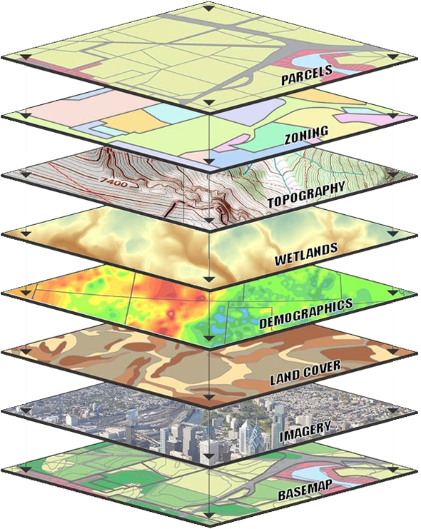
A geographical information system (GIS) is a software and/or online platform that can be used to gather, manage, visualize and analyze ‘spatialized’ data. Spatialized data (also known as geo-data) is any type of information that is geo-referenced. Data are geo-referenced when they are given a specific location. For instance, you could describe University Hall as the building where the UTA Department of History resides. You might add to your description of the building by creating a spreadsheet that includes the names of other departments in the building, a count of the number of rooms in the building, the number of floors, the number of faculty offices, the number of classrooms, the age of the building, the date of the last inspection of the elevators, and so on. But these data do not become geo-referenced until you add the geographic information that University Hall sits at the intersection of 32° 43′ 44.9″ north latitude and 97° 6′ 50.84″ west longitude. GIS integrates different types of geo-data (such as the site of an historic event, population figures of the area, its environmental factors, topography, climate, etc.) and then ‘stacks’ this information into geo-data layers to create map visualizations and 3D scenes (see Fig 1).
How can GIS be used for Historical Research?
In The Landscape of History (2002), John Lewis Gaddis asks, “What if we were to think of history as a kind of mapping?”[3] He then connects the ancient practices of mapmaking with the archetypal three-part conception of time (past, present, and future). Gaddis observes that both mapmakers and historians try to identify patterns and manage infinitely complex subjects by imposing abstract grids on time (chronologies: centuries, decades, years, months, days, hours) and space (latitude and longitude, and map projections).[4] As a geo-data platform, GIS spatially parses and itemizes attribute data (as a row of statistics, a string of text, an image, a movie) by linking latitude and longitude coordinates to representations of the locations of the data. Although GIS is viewed by many as a mapping tool, its software and online platforms are evolving into new forms of interactive online media practice called Neogeography (smartphone, web, Big-Data and social media mapping). A list of projects, programs and web-links can be found on the Association of American Geographer’s Historical GIS Clearinghouse and Forum website.[5] GIS offers a variety of practical uses for the study of history. First, pieces of historical cartography can be digitized, geo-referenced and rubbersheeted (stretched and plotted to modern coordinates) to visualize perceptions and perspectives from the past involving discovery, migrations, settlements, military campaigns and battles, etc. Second, GIS can be used to geo-reference census, parish, archival records and time-series population, housing, agriculture, and economic data, which can then be visualized and analyzed in two and three dimensions through the application of spatialized aggregate statistics. Third, GIS can reconstruct past historical sites, in addition to dynamic events, by creating scenarios through the integration of vector (point, line and polygon) and raster (digital image) geo-data models. GIS skills are in high demand in many fields and are now being used in fields such as library and archival science, the digital humanities, journalism (broadcast, and streaming) and film and gaming.[6] A practical overview of GIS methods for historical studies is discussed in the E-Book A Place in History by Ian Gregory. In addition, the ArcGIS Online Lesson Tell the Story of Irish Public History provides an introductory level tutorial on how historical geo-databases can be used to create a variety of interactive, online mapping applications. Other examples of GIS methods for historical research can be found in Anne Kelly Knowles’ Past Time, Past Place: GIS for history (2002), Ian Gregory and Paul Ell’s, Historical GIS: Techniques, methodologies and scholarship (2003), and Charles Travis’ Writing time and space with GIS: The conquest and mapping of seventeenth-century Ireland (2015). In addition, a volume edited by David Bodenhamer, John Corrigan and Trevor M. Harris The Spatial Humanities: GIS and the future of humanities scholarship (2010) set out a vision for trans-disciplinary GIS applications by integrating methods from history, literary studies, philosophy, linguistics, religious studies and other humanities fields.
History, Geography, and Historical Geography
Among the many emerging areas of interest in geography and GIS is the scholarly return to the relationship between history and geography. History is often misunderstood to be about memorizing dates. Geography is often misunderstood to be about memorizing locations. Both disciplines have suffered from these perceptions. Those who study either discipline in depth quickly realize that, while dates and locations are important foundations, neither is a central purpose of the discipline. At the risk of oversimplification, it is helpful to think of the relationship between geography and history as follows. Historians are concerned with the whys of when, while geographers are concerned with the whys of where. The historian focuses not just on when something happened, but why that when matters. Similarly, geographers focus not just on where something is located or occurs, but why that where matters. Historians have constructed and named eras and periods as tools for understanding chronology (relationships in time), while geographers have constructed and named regions as tools for understanding chorology (relationships in space). Yet neither eras nor regions are agreed upon by all historians or geographers respectively. As W. Gordon East, in The Geography Behind History observes, “the familiar analogy between geography and history as the stage and the drama is in several respects misleading, for whereas a play can be acted on any stage regardless of its particular features, the course of history can never be entirely unaffected by the varieties and changes of its settings.”[7] In fact, one of the animating features of both disciplines is the scholarly attempt to demonstrate that certain eras or regions have been misunderstood, require further study and definition, or should be thrown to the ash heap. Nevertheless, these primary concerns with time and space suggest that history and geography are complementary and interdependent fields of study. To emphasize the significance of this relationship, historian Phillip J. Ethington has advanced a provocative argument that situates geography as central to the study of history:
The past cannot exist in time: only in space. Histories representing the past represent the places (topoi) of human action. History is not an account of “change over time,” as the cliché goes, but rather, change through space. Knowledge of the past, therefore, is literally cartographic: a mapping of the places of history indexed to the coordinates of spacetime.[8]
While most geographers and historians have long recognized the need for the perspectives of the other discipline in their scholarly endeavors, some geographers and historians have sought to unite the fields more explicitly. While the current trend among historians is to refer to this work as environmental history, geographers tend to call the field historical geography. Regardless of the moniker, scholars who study the geographies of the past or the relationships between humans and their environments over time are pursuing work that brings the temporal dimension to geography as well as the spatial dimension to history. Among twentieth and twenty-first century geographers, this work has spanned a variety of themes such as the influence of the physical environment in shaping human societies, the ways in which cultures construct landscapes that represent their values, the diffusion of ideas and objects across spaces through human movement and communication, the ways in which humans develop attachments and identities centered on places and spaces, the experience of race, class, and gender in various cultural landscapes over time, how spatial relationships and processes are related to power, and how discourse, ideologies, and identities over time have shaped human spatial thinking. Though the work is not always referred to as historical geography, much of the current research on climate change, urban growth, globalization and other important topics today make use of the lenses of knowledge best polished by the historical geographer.
Geography and GIS can be an important to a Historian’s spatial understanding of a topic. Consider the map below of the first time soccer was played in Africa
What does it mean when many of the first places soccer was played were on the coast? What hypothesis can you make about the role of soccer or the nature of colonialism?
- For more on the history of geography, see G. J. Martin. 2005. All Possible Worlds: A History of Geographical Ideas, 4th Edition. Oxford: Oxford University Press. ↵
- For more on research methods in geography, see D. R. Montello and P. C. Sutton. 2006. An Introduction to Scientific Research Methods in Geography. Thousand Oaks, CA: Sage; I. Hay. 2016. Qualitative Research Methods in Human Geography, 4th Edition. Oxford: Oxford University Press. ↵
- J. L. Gaddis. 2002. The Landscape of History: How Historians Map the Past. Oxford: Oxford University Press, 32. ↵
- Ibid. ↵
- AAG Historical GIS Clearinghouse and Forum http://www.aag.org/cs/projects_and_programs/historical_gis_clearinghouse/hgis_projects_programs ↵
- Esri CityEngine, Film and Gaming https://www.esri.com/en-us/landing-page/lp/esri-cityengine/3d-gis/cityengine-film-gaming ↵
- W. Gordon East. 1965. The Geography Behind History. New York: Norton & Company, Inc., 2. ↵
- P. J. Ethington, “Placing the Past: ‘Groundwork’ for a Spatial Theory of History,” Rethinking History 11 (2007): 465-493. ↵
