2 Where Are We Going?
Where are we going?
Let’s talk geography! That’s your favorite subject, right? Probably not, but it is an important topic relevant to our overarching question, “Where Does Art Come From?” You probably already noticed while reading “Where Does Art Come From? An Introduction” that we’ve got to know a bit about geography to consider global art history. We’ve also got to dive into some population genetics to understand human migration, so hold onto your hats!
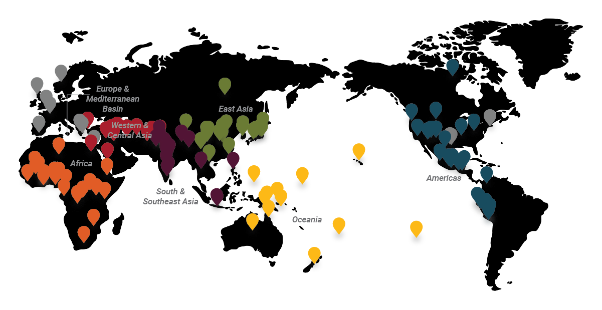
There are seven major regions that are relevant to the discussions in this book: Africa; Western Asia & Central Asia; South & Southeast Asia; East Asia; Oceania; the Indigenous Americas; Europe, the Mediterranean Basin, and Euro-America. The key on Figure 2.1 illustrates these regions. P.S. That color coding will be consistent for every map in the book!
For cultural and artwork discussions, we’ll be focusing on the first six regions but also discuss how European contact and colonization, as well as Euro-American settlement and globalized culture, has impacted arts around the world (as you probably guessed). Ancient traditions from the Mediterranean Basin, such as Egypt and Mesopotamia, are considered part of the Western Canon and thus are bundled with Europe. But, remember that there’s some fuzziness there so you’ll see some ancient Egyptian and Mesopotamian examples included in this text. Then, once Muslim leadership and patronage in North Africa and Western Asia emerges, the classification fully switches to the global category of art history. So, the geography remains the same but the art historical perception of the region changes over time.
Check out the regional maps below to consider what you know about the geography, including both physical and cultural geography, of these six major regions. Some of the geographical terms may not be as familiar to you as others. Below, we’ll cover some of the reasons why certain terms are used and how they relate to popular terms today.
Another important thing to consider is whether the present-day boundaries of countries have any bearing on the past. In many cases, they don’t. Contemporary boundaries obviously resonate with contemporary artists and artworks, but many of the artworks discussed in this book derive from regions from historic territories or from regions that were not independent (and therefore given their contemporary names and boundaries) until the 1950s CE or later. You will see the term ‘present-day’ country in the text to continually remind you that these boundaries were not relevant to peoples of ancient and historic cultures.
As you review the regional maps, also consider the clustering of artworks and the sub-regions that are represented. The voids in these maps may reflect that those areas were unoccupied (thus, there weren’t artists living there and producing artworks) or that arts produced there aren’t well-studied. As you know, art history doesn’t treat all areas of the world the same. This means that some areas are very underrepresented or totally unrepresented. Maybe you can change that if you become an art historian or archaeologist… wink wink.
Africa
Let’s start with the geography of Africa (Fig. 2.2). Let’s think about five primary regions within Africa: North Africa, West Africa, East Africa, Central Africa, and Southern Africa (not to be confused with the present-day country of South Africa, which is part of, but not the only part of the southern Africa region). This regional division is a simplification because the continent is huge and very environmentally diverse. There’s the arid Mediterranean coast of North Africa that turns into the Sahara Desert. Did you know that the Sahara wasn’t always a desert? Around 6000-4000 BCE, it was more like the savanna environment that we see across West and East Africa today (which people often associate with the landscape depicted in Disney’s “The Lion King”). We’ll cover some artworks from southern Algeria that demonstrate how non-desert-like the Sahara was thousands of years ago in “Where Do Babies Come From?”.
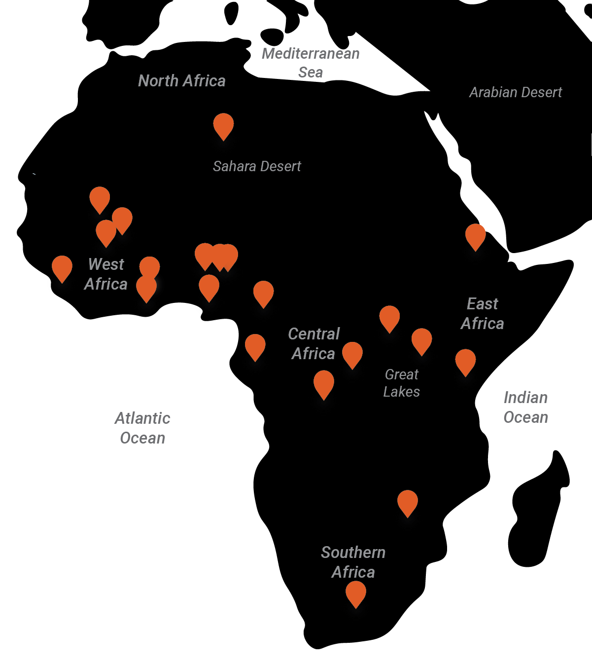
As you expect from “The Lion King,” the savanna is where you find the large-bodied animals so synonymous with the continent: elephants, rhinos, giraffes, zebras, and, of course, lions. In West Africa, the savanna transitions into coastal forests, sometimes called the Atlantic Forests, of present-day Côte d’Ivoire, Ghana, Benin, Togo, and Nigeria. These regions supported agricultural societies focused on either rice or yams.
The present-day countries of Gabon, Republic of the Congo, Democratic Republic of the Congo, Uganda, Kenya, and Somalia sit directly at the Equator. The equatorial rainforests are dense west of the Great Lakes. The Great Lakes region, including Lakes Victoria and Turkana, is the cradle of humanity, preserving the oldest remains of Homo sapiens sapiens and our human ancestors. Check out the “Human Evolution Interactive Timeline” from the Smithsonian for more on this huge topic that we can’t cover here. Farther south, the environment transitions into savanna again across southern Democratic Republic of the Congo, Angola, and Zambia. There are smaller deserts than the Sahara in the present-day countries of Namibia, Botswana, and South Africa. This is where most of the surviving species of native African animals are protected in land reserves.
These environments determine the local resources and materials available for art-making, such as woods from the Central African forests and clays from the savannas. There’s always trade opportunities for non-local resources but resources from distant regions often fetch a high price. Therefore, only certain people in society really have access to non-local resources. Few artworks originate in the deserts because few people live there, if any at all. But artworks traverse the deserts through trade, especially through the Trans-Saharan trade networks, for example. One prominent item of trade across Africa, and out of Africa, was ivory, procured from elephants and rhinos.
P.S. Did you already skip ahead and see Figure 2.7? Check out that map illustrating what scholars have discovered via genetic studies: the island of Madagascar off the east coast of Africa was populated by seafarers from Southeast Asia before anyone from mainland Africa got there!
Western & Central Asia
Historically, Africa was physically connected to only one other landmass: Eurasia. The Sinai peninsula connected present-day Egypt to Israel, before the Suez Canal was dug in the 1860s CE. That project allowed traffic from the Mediterranean into the Red Sea, instead of having to sail all the way around Africa. But it broke the ability to physically walk from Africa into Eurasia, which has been such an important pathway for our human ancestors over time. It’s not a big deal today, but imagine if they couldn’t have navigated that region as easily back then. Human history would be drastically different!
Given their proximity, North and East Africa have had strong ties to the neighboring major region, Western Asia, which is combined with Central Asia for the purposes of this book (because we have so much to cover in so little time) (Fig. 2.3). Firstly, let’s talk about terminology. We use the term Western Asia instead of terms that may be more familiar to you. For example, US-based audiences often hear the geographic terms Middle East, the Arab World, etc. to refer to this part of the world. Those terms relate to Near East (referring to the Mediterranean coast of Asia; aka the Levant) and Far East (a way of describing East Asia). Obviously, ‘near,’ ‘middle,’ and ‘far’ are relative terms, based on the distance from…; you guessed it: Europe. Directional terminology like west and east also are European inventions but today, they feel more objective. So, we’ll divide the continent of Asia into Western, Central, South, Southeast, and East Asia.
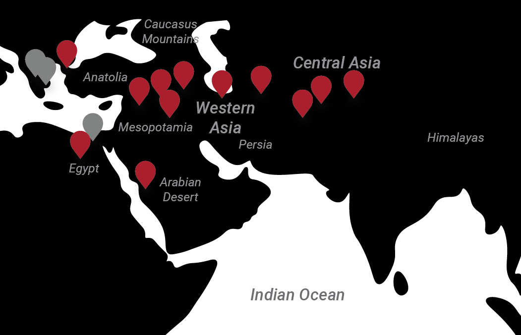
Western and Central Asia are distinct regions environmentally and culturally. They are both relatively dry but Western Asia is home to the Arabian Desert, which contains one of the largest continuous masses of sand in the world. Not too far away, the Mediterranean coast is considered one of the most pleasant places to live or visit in the world. But, that preference has a lot to do with the bias towards Western culture. The Mediterranean coast was the hub of activity between Egypt, the Levant, southern Europe, and into Mesopotamia. This western-most part of Western Asia has been called the ‘Fertile Crescent’ because it incubated the rise of agriculture in western Eurasia. There were separate agricultural ‘revolutions’ in East Asia, the Americas, and elsewhere.
The eastern part of Western Asia comprises the arid parts of present-day eastern Iraq, Iran, and Afghanistan. Present-day Iran generally corresponds to the ancient region of Persia. Many of the inhabitants of Iran today still speak Persian (Farsi). Depending on the source, Afghanistan is considered part of Western Asia, Central Asia, or South Asia. It is one of those crossroads of the world, often traversed as part of the Silk Roads, with both environmental and cultural similarities to neighboring areas of all three major regions.
Central Asia generally sits north and to the east of Western Asia. Though, the region is quite nebulous. The Caucasus Mountains region between the Black Sea and the Caspian Sea functionally separates present-day Russia from Georgia, Azerbaijan, and Armenia, as well as Central Asia from Western Asia on the western side. On the eastern side, the present-day countries of Turkmenistan, Uzbekistan, Tajikistan, Kyrgyzstan, and Kazakhstan were the lands of the Silk Roads that led merchants north of the Himalayas into China. These ancient highways of trade and ideas were incredibly important to the history across Eurasia and the world at large. Western Asia has very strong contacts with Europe while Central Asia has strong contacts with East Asia and served as the intermediary of trade from East Asia to the west.
Textiles are particularly important products in both Western and Central Asia, as the term Silk Road implies. Bundles of fabric, silk and otherwise, traversed these regions for thousands of years. Other prominent arts include pottery and stone sculpture. Stone or brick architecture is also important to the visual culture of these regions, including monuments built along the Silk Roads to promote faiths and political agendas. Metal working was practiced in these regions from the earliest periods of technological development. This region is also home to a number of special materials like lapis lazuli and bitumen (natural tar).
South & Southeast Asia
Like Western and Central Asia, South Asia and Southeast Asia are distinct regions but they share certain elements of history, particularly religious movements, that are helpful to consider together. South Asia (Fig. 2.4) primarily refers to the Indian Subcontinent (present-day India, Sri Lanka, Nepal, Pakistan, Bhutan, and Bangladesh), which is the landmass that drifted into the Eurasian continent 55 million years ago and created the Himalayas through continental impact and uplift!
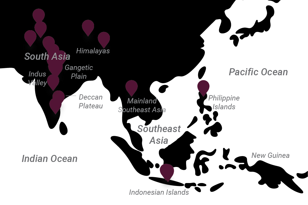
South Asia is diverse environmentally with the highest elevations in the world to the north and dense jungles in the south. The region along the border of India and Pakistan is forested and riverine. As you go west and north, the climate begins to dry out. Nepal and northern India feature the Himalayan foothills and the Gangetic Plain (focused on the Ganges River). The Deccan plateau of central India features remarkable cave and rock formations as well as river valleys and waterfalls.
South Asia exemplifies why present-day country borders do not matter to the ancient past. The Indus Culture (one of the oldest agricultural cultures known in the subcontinent) settled the Indus River Valley which forms the border between India and Pakistan today. Indus peoples lived on both sides of the river with two major cities spanning the modern border: Harappa, India, and Mohenjo-Daro, Pakistan. Then, immigrants on chariots from Central Asia arrived, through present-day Afghanistan. They didn’t care about borders!
South Asia also is a good example of how place-names transform over time. The oldest written record (that we can currently decipher) of the lands we call South Asia today, called the Rig-Veda, describes this region as ‘Sindhu.’ Check out “What is Divine?” for more about the Vedas. Neighboring cultures such as the Persians pronounced this term without the ‘s’ at the beginning, so it became ‘Hindu’ or ‘Hidush.’ It was the Greeks, first arriving during the incursions of Alexander the Great into present-day Afghanistan and Pakistan, who translated ‘Hindu’ into Ἰνδία (India) and called the people of the region Indos (Indian). But the term ‘Hind’ also stuck around for a while among Arab writers. It wasn’t until the end of British colonialism and the independence movement of South Asia that India was separated from the present-day countries of Pakistan and Bangladesh.
Southeast Asia is connected to South Asia primarily through sea routes but is also connected via land, across the present-day borders of India, Bangladesh, Burma/Myanmar, and Malaysia. Southeast Asia comprises a mainland (south of present-day China) and archipelagos known today as Indonesia and the Philippines. Southeast Asia is predominantly tropical, especially in the southern areas. Northern regions of present-day Vietnam, Laos, and Burma/Myanmar are relatively mountainous and feature highland forests.
The Philippines comprises many relatively small islands while the Indonesian archipelago features large landmasses including Borneo, Sumatra, Java, and portions of New Guinea. Today, New Guinea is divided into Irian Jaya, Indonesia, (on the west side) and Papua New Guinea (PNG; on the east side). PNG is part of the Oceanic region, discussed below. The Philippines is quite close to Taiwan and the mainland of China. You might be wondering where the Philippines got its name. Any guesses? King Philip of Spain put his stamp on these islands, grabbing it as a colonial territory in 1565 CE. Eventually, the Philippines was taken over by the US after the Spanish-American War and continues to be highly influenced by the US, though it is an independent country today.
South Asian resources are vast, since the environments are diverse. In particular, India is full of excellent building and sculptural stone. Geological formations contain gemstones like emeralds while Asian elephants and rhinos were exploited for ivory. Perhaps the best known products of South Asia are tea and spices. These were the things that motivated strong European investment, through colonial endeavors like the Dutch and British East India Companies. These enterprises also made impacts in Southeast Asia, often exporting ‘exotic’ woods from mainland and island forests. The region is also home to incredibly diverse tropical species of birds, monkeys, and other animals. Feathers, furs, and other forest products were important luxury and export items.
East Asia
The present-day country of China dominates the region of East Asia today, along with the Korean Peninsula (North and South Korea), Mongolia, Taiwan, and the Japanese archipelago (Fig. 2.5). China is vast, comprising a wide variety of physical features including the heavily populated river valleys of the northeast and central area, the Gobi Desert in the far north and center, as well as the Himalayas and Plateau of Tibet in the west. For much of its history, major population settlement focused on the eastern part of China between the Yellow River and Yangtze River. Southeastern China is forested and similar in climate to Vietnam. Coastal population centers developed there include Hong Kong and Shanghai. The arid regions of northwest China border the Central Asia territories of Silk Road intermediaries, who took northern routes to avoid the high elevation Himalayas. FYI: “The Silk Road(s)” is a modern term developed by German scholars to describe a vast array of trade relationships. It is a convenient simplification.
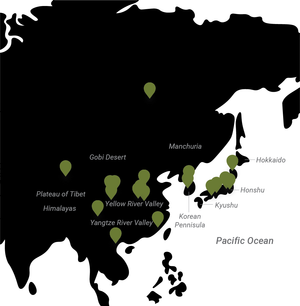
Northeast of present-day Beijing (which was established relatively late as a capital) is the region historically known as Manchuria, the home of the Manchus (an ethnic group that came to rule over all of China during the Qing Dynasty). Manchuria is connected to the Korean Peninsula to the south. The Hamgyong Mountains create a natural boundary between these regions. Today, North Korea is predominantly mountainous while South Korea features a lowland environment quite similar in climate to northeast China.
The diversity of the mainland physical features corresponds to the cultural diversity of mainland East Asia. Most Western media conflate all Asian groups into one mass. But it is important to recognize the distinct cultural traditions and histories originating for these regions. Most people understand that China and Japan are distinct, since Japan is a set of islands, but the understanding of the distinctions of China and Korea are less known. It is true that there were strong contacts and influence between China and Korea but they are certainly not the same.
Japan comprises five islands, the central and largest of which is Honshu. It is heavily forested with volcanic mountains, such as the famous Mt. Fuji near present-day Tokyo (historic Edo). To the north, the island of Hokkaido was probably the home of the earliest inhabitants of Japan, the Jomon peoples. Immigrants from Korea and China reached Japan across the small Strait of Korea, landing on the southernmost Kyushu island. Jomon peoples merged with mainland immigrants, developing traditional Japanese culture known as the Yayoi culture. Jomon cultural elements remained present in Japan throughout its history but only recently have they been celebrated to the same level as Yayoi cultural elements.
As mentioned above, East Asia is known for its silk textiles and developed long-lived trade relationships with Central Asian people. Stone, ceramic, brick, and wood are prominent building materials, with brick more frequent in China, stone more frequent in Korea, and wood more frequent in Japan. Pottery was produced by all peoples, with the earliest innovations in Japan. Eventually, the development of kaolin clay-based porcelains in China changed the game for pottery and ceramic production, eventually greatly impacting the market for luxury items in the West. Special materials like jade are highly prized within East Asia and as export items to the wider world.
Japan has a long coastline of the Pacific Ocean, which brought many foreigners to the islands. Early Europeans included the Portuguese and the Dutch, but eventually American Commodore Matthew Perry arrived on Japan’s Pacific coast in 1853 CE and demanded that Japan’s leaders begin trading with the rest of the world. This marks the global emergence of Japan in the modern era, including major events such as their colonization of Korea and World War II. The conflicts between the US and Japan during World War II were primarily undertaken across the Pacific and incorporated many waypoints, such as the Micronesian islands of Oceania.
Oceania
Oceania may be one of the least familiar regions to many Euro-American readers, except maybe for the islands of Hawai’i or cities like Sydney, Australia. This is a vast region incorporating all habitable land of the Pacific (thus it is sometimes referred to as the Pacific or South Pacific [because it does not typically include the northern Pacific regions of Siberia and Alaska]). Oceania can be divided into four sub-regions: Australia, Melanesia, Micronesia, and Polynesia (Fig. 2.6). The landmasses were occupied by humans in that order. As early as 65,000 years ago, humans island hopped across present-day Indonesia, entered Melanesia through New Guinea, and then crossed into Australia. Those peoples became the indigenous Australians, known as Aboriginal peoples and Torres Strait Islanders. To populate all the islands of Micronesia and Polynesia, people had to get in canoes and sail, without seeing any destination in sight. Imagine the courage!
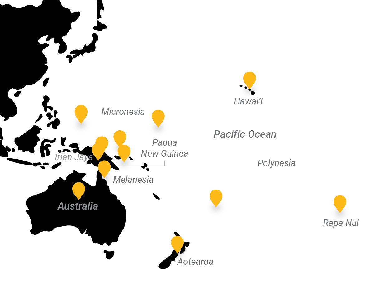
You’ve probably seen a pattern in the naming convention already. The suffix –esia refers to collections of islands. The melan– of Melanesia refers to skin tone. Those with dark skin tones have more melanin and those with lighter skin tones have less. Vitamin D absorption, which is super important for our health, is a big reason for this. If you live at or near the equator (or at high elevation elsewhere), you are exposed to the most intense and highest levels of sunlight. If you live far away from the equator (and/or in low elevations), you’re getting less sunlight overall and lower intensities. Thus, people in latitudes far from the equator have less opportunity to absorb Vitamin D and so have adapted to have lighter skin tones so that they can absorb at higher rates. Dark skin tones of people at and near the equator help protect them from too much Vitamin D absorption, and other ill effects of UV radiation, such as skin cancer. Melanin levels also impact folic acid production, which has implications for the success of pregnancies (and therefore, the production of the next generation). For more details, check out “Modern Human Diversity – Skin Color” from the Smithsonian.
That’s a long-winded explanation for how Melanesia got its name. The many indigenous populations of Papua New Guinea and the other islands of Melanesia, as well as Aboriginal peoples of Australia, have dark skin tones. Papua New Guinea is at the same latitude as Central Africa and thus it makes sense that populations in both areas would have dark skin tones to protect from UV overexposure. Since all human ancestry derives from Africa, it is accurate to say that humans started with high melanin levels (adapted to the central region of East Africa), and eventually adapted lower levels of melanin if they migrated into areas with lower UV exposure. Skin tone is a gradient mostly based on geographic origin. Short-term migrations do not impact skin tone. It takes evolution over many generations to adapt melanin levels to new geographies.
Have you guessed by now how Micronesia got its name? It is home to some of the smallest islands in the world, some of which are too small to really support permanent settlement (without modern transoceanic shipping, etc.). Small island size restricts population growth so islands usually have small populations, until modern infrastructure changed the game. Today, most of these tropical islands are politically joined through the Federated States of Micronesia but some, such as Palau (discussed in “Where Do Babies Come From?”) are independent.
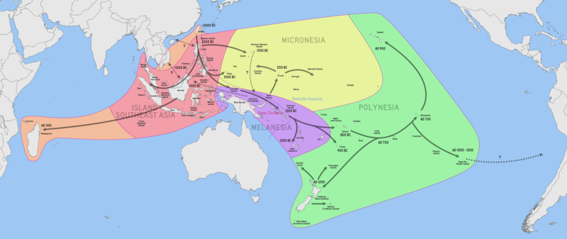
The largest region of Oceania is Polynesia, which refers to ‘many islands,’ but is unique because of how far apart the islands are. Check out the distance between Samoa (one of the western most Polynesia islands) and Rapa Nui (aka Easter Island) (Fig. 2.6; about 6489 km, 4032 miles, or 3504 nautical miles). Masters of outrigger canoes set sail and island hopped for centuries, eventually reaching the farthest islands of Polynesia (the Hawai’ian archipelago to the north, Rapa Nui to the east, and Motu Maha [Auckland Islands] to the south) (Fig. 2.7).
Like Melanesia and Micronesia, the Polynesian islands are relatively small (except large land masses like the two islands of Aotearoa [indigenous Maori name for present-day New Zealand]). Polynesian islands are also particularly volcanic, and thus subject to severe events such as eruptions or lava flows. In addition to volcanic stones, ocean resources such as shells, materials derived from marine wildlife, and tropical woods are the most common art materials on most islands. Australia includes a large central desert, thus resources are relatively scarce and art is focused on stone-based pigments.
Indigenous Americas
Don’t let the dotted line on the right side of Figure 2.7 mess with you. The continents of the Americas were not populated from Rapa Nui. They were populated via migration from Asia across the Bering Strait (a sea between present-day Siberia and Alaska) and along the Pacific coastline of the Americas. During the earliest parts of human history, the Americas were isolated by huge oceans and unoccupied (and covered by huge glaciers for long periods). By around 40,000 years ago, climate change and the human tendency to migrate changed that! Check out “How the First Americans Got There” (Fig. 2.8) to learn about the most recent studies of how people got into the Americas.
The ancestral Siberians, Ancient Beringians, and northern and southern Native American ancestors are all part of the development of indigenous populations across the continents. As the SciShow video describes, the northern and southern Native American ancestors moved into North America pretty quickly. Climate change and sea level rise coincided with the melting of the large glaciers (which resulted in Beringia being covered with water and now being the Bering Strait). Eventually, the modern coastlines and physical geography of North America were exposed. This happened quickly, as did migration of animals and the hunters that followed them into the Americas. By 18,500 years ago, people had already migrated all the way down to Monte Verde, Chile, on the continent of South America. This may have occurred via boat and/or on foot along the coastline.
Before we move forward, we’ve got to address the elephant in the room: how we describe these landmasses and the term “America.” Firstly, the land masses are two separate continents but we recognize three primary regions within them: North America, Mesoamerica/Central America, and South America (Fig. 2.9). The distinction between North America and Mesoamerica/Central America is based on environmental differences, though it can be quite arbitrary. For example, people debate whether northern Mexico is part of North America or Mesoamerica.
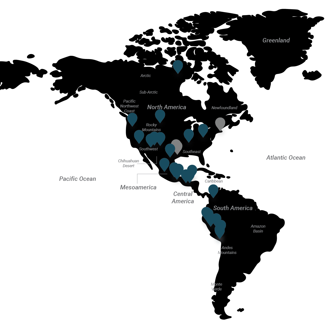
The terms Mesoamerica and Central America can be interchangeable but archaeologists use the term Mesoamerica to describe cultural similarities across the southern half of present-day Mexico, Guatemala, Belize, Honduras, El Salvador, and the northern islands of the Caribbean. Archaeologists use the term Central America to describe the transitional zone into South America (the present-day countries of Nicaragua, Costa Rica, Panama, and many of the southern islands of the Caribbean). The continent of South America starts between present-day Panama and Colombia. Mesoamerican/Central America and South America feature distinct climates and cultural histories, thus they are recognized as distinct regions.
So, what about the term “America” itself? All the indigenous peoples of the continents we call the Americas never used that term to describe their land prior to Spanish colonization. As all children of the American public school system learn, ‘in 1492, Columbus sailed the ocean blue…’ Cristoforo Colombo (aka Cristóbal Colón, aka Christopher Columbus), an Italian navigator, was sponsored by the Spanish King Ferdinand II and Queen Isabella I to find a route to India by heading west, not south and east (around Africa and into the Indian Ocean). Instead of finding India, he landed in the Bahamas and eventually, over four voyages across the Atlantic Ocean, he landed on or sighted most of the Caribbean Islands and the mainland of Central America and South America. Columbus thought he had found some part of Asia, calling it the ‘West Indies,’ and told everyone who would listen back in Spain and across Europe. This is why indigenous Americans were called ‘Indians’ for a long time.
Columbus’ ships weren’t the only ones crossing the Atlantic by the early 1500s CE. Others were landing on the coast of present-day Brazil and Florida. One guy named Amerigo Vespucci, another Italian-born navigator working for Spain and Portugal, is thought to have been the primary skeptic who said that the lands Columbus encountered were not Asia. Vespucci suggested that those lands were a Mundus Novus or ‘New World’ (Vespucci 1503). A few years later in 1507, some French and German cartographers learned of Vespucci’s suggestion, were convinced he was right, and published the first maps with the term “America,” as a Latinized version of Amerigo’s name (it could have been ‘Amerige’ but the cartographers thought that a feminized word was better). It is typical for cartographers to borrow terms and continue conventions developed by previous makers so the term stuck. It took a while for ‘America’ and ‘American’ to replace the terms ‘West Indies’ and ‘Indian’.
So, anyone who calls themselves an American is actually named after an Italian guy. That’s how history works sometimes. While most Native American peoples use that term as a representation of their identity, most prefer their indigenous cultural names to recognize that ‘American’ and ‘Indian’ are actually colonial impositions upon them.
The Americas are environmentally diverse with the basically uninhabitable arctic/polar regions of the north transitioning into the habitable sub-arctic and temperate zones of present-day Canada and the US. Let’s pause here and address what some of you may have been shouting at the page. Yes, there is good evidence that a small group of Norse (not necessarily Vikings) explorers followed the coastlines of Iceland and Greenland (starting from their homeland in Scandinavia), eventually reaching present-day Newfoundland (far northeastern Canada). An archaeological site called L’Anse aux Meadows was occupied between 990-1050 CE and represents a short-term settlement by Norse people. It is likely that these Norse settlers saw and/or developed relationships with indigenous people of the region (the ‘Dorset’ discussed in “Who Am I?”). There may have been conflicts with the Dorset and/or other circumstances that encouraged the Norse to move back to Greenland. Two Norse sagas mentioned a land called Vinland west of Greenland that was unsuccessfully colonized for a short time. Many scholars think that Vinland is the Norse name for Newfoundland and the surrounding region that they explored. This is an important piece of colonial history but all in all, the Norse didn’t have much impact on the Americas.
Moving south into North America, there are unique regions, such as the wet and cold Pacific Northwest Coast (incorporating the coastlines of Canada and the US) home to richly diverse indigenous groups. The Rocky Mountains are a transitional zone from east to west and north to south, bounding the northern temperate zones and the arid Southwest region (present-day Utah, Colorado, New Mexico, Texas, Arizona, and California). Those arid regions do not stop at the US-Mexico border but continue into northern Mexico, with a large continuous region, the present-day Chihuahuan Desert, inhabited for thousands of years by related indigenous peoples. The southeast US is a unique region characterized by bayous and swamp where people have always worried about floods, mosquitos, and crocodiles.
The Valley of Mexico, which hosts present-day Mexico City, is a plateau surrounded by mountains and volcanoes. Those mountains bound the semi-tropical regions of Mesoamerica and Central America, with Caribbean and Pacific coastlines. The Caribbean islands are predominantly semi-tropical as well. As in Africa, the semi-tropical forests transition into rainforests at the equator, with the Amazon forests dominating the northern part of South America. Very close to the Pacific coast of the continent, the Andes Mountains create a unique environmental transition from dense rainforest in the east to highlands, and then steep descents to a coastal desert in the west (covering the coastlines of present-day Ecuador, Peru, and Chile). South of the Amazon, the Andes also transition into a desert in present-day Chile and Argentina. A good part of the southern coasts of South America are temperate.
Given this diversity, arts from the indigenous Americas are incredibly diverse. Most regions have abundant clay, stone, and wood resources. That diversity increased as indigenous trade networks were built over time and as colonial trade networks emerged. In terms of special materials, the Americas has its own sources of jade and jadeite (jade-like greenstones), as well as obsidian, ivory from walruses and whales, and gold from the Andes. The most glorious resource to derive from the Americas is cacao, hands-down. We’ll talk about it, don’t worry!
The Wrap-up
Geography is crucial to understanding cultural context, resource availability, and environmental influences. So, we’ll be talking about geography a lot in the coming pages. The production or find location of every artwork discussed will be offered to as much precision as possible. You’ll find location information in the caption of each artwork and oftentimes it will be directly discussed in the text. Use the maps from this chapter and those provided in each following chapter to visualize geographies and timescales.
News Flash
- Did you know there is a Geography Awareness Week in the US? Join in during the third week in November annually!
- In addition to the “Human Evolution Interactive Timeline,” the Smithsonian National Museum of Natural History has a whole program called “Human Origins” with tons of updates by @HumanOrigins on Twitter.
- There are many melanin-focused/inspired social media venues, such as #MelaninPoppin, Melanin Book, and MelaninPeople.
- Columbus is a controversial figure in many indigenous American communities. Thus there has been a strong movement to replace Columbus Day (on the second Monday in October) with Indigenous Peoples’ Day. Several states have already made the change.

.png)