11 Why Does Size Matter?
Why does size matter?
Don’t worry! We won’t be getting into self-conscious comparisons among young men in this chapter. We’re talking about what scholars call monumentality, the practice of creating massive and/or imposing and/or enduring features. SPOILER: No aliens required.
These features are what we call monuments (like Stela Depicting Kaloomte’ K’abel [Fig. 8.4] from “Who Came Before Us?”) and monumental architecture. We often marvel at the accomplishments of ancient people and curate lists like the ‘Seven Wonders of the Ancient World’ discussed in “Where Does Art Come From? An Introduction” or ‘New7Wonders of the World’ developed by the New7Wonders Foundation. The old list featured only monuments from the Mediterranean region and thus is dominant in architectural histories focused on the Western Canon. The new list offers global representation, demonstrating that monumentality is not a Western thing, but a human thing. Have you ever wondered why humans are so fascinated by big things like buildings and why people spend huge sums on trips to see monuments around the world?
Big things and how they impact us
Humans have an innate interest in things that are big, probably because the scale difference between huge structures and our weeny bodies demonstrates an inescapable truth… we are small in comparison to the world around us. Remember Streams and Mountains without End (Fig. 6.11) from “What is Important to Us?” In that chapter, we focused on the inscriptions scholar-officials inked onto the scroll, but the painting itself exemplifies a tradition relevant to monumentality. The shan shui (‘mountain water’) landscape of Streams and Mountains without End also includes house structures, fences, and people. Fig. 11.2 provides a detail.
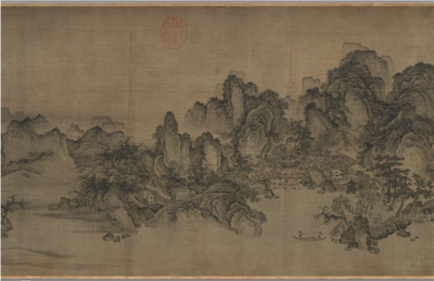
Most importantly, these human-made features and the humans themselves are dwarfed by the mountains. Typically, this sort of imagery is presented on a vertical hanging scroll with a towering mountain lurking over a body of water and tiny humans in the foreground. This painting tradition is thought to reflect the Daoist idea that nature is preeminent and humans must learn humility through the observation of nature. For most people, standing at the base of a mountain or a monumental building inspires humility.
On the other hand, there is another way to view monumentality: from the point of view of powerful people. Let’s dive into some theory. Sociologist Thorstein Veblen (1899) in The Theory of the Leisure Class developed the concept of “conspicuous consumption” to describe how people buy more or higher-quality goods than they practically need. This consumption/acquisition of luxury goods is often done in view of others (at a market, on display in one’s house, etc.) and thus is conspicuous (noticeable, and even attracts attention). P.S. Veblen was critical of this practice, also calling it “wasteful” consumption.
So how does this apply to monuments? Archaeologist Bruce Trigger (1990) applied Veblen’s concept of conspicuous consumption to ancient architecture in “Monumental Architecture: A Thermodynamic Explanation of Symbolic Behaviour.” Trigger argues that monumental architecture was one of the, if not the most, paramount luxury goods in ancient societies. To build a monumental structure like the El Castillo acropolis (Fig. 11.3) at the ancient Maya site of Xunantunich, Belize (Fig. 11.1), for example, someone would have to control/consume the energy (labor) of other people. The patrons of El Castillo (many rulers of Xunantunich) could not have built the structure themselves (and it certainly wasn’t aliens). Instead, Xunantunich rulers exercised social and political power over people with less status by commissioning their labor to produce a monument, thereby ‘consuming’ the labor of others.
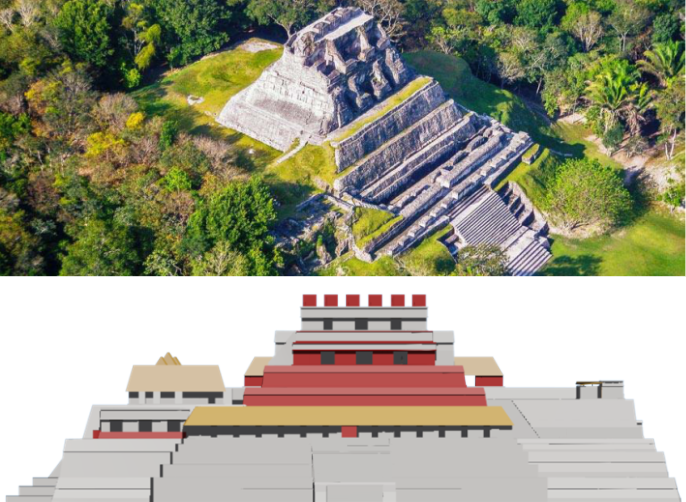
This labor would have been highly conspicuous. The ancient Maya often built their cities on hilltops, and cleared them of most forest growth to make way for massive structures and plazas. Thus, as masons constructed buildings as tall as El Castillo (over 120 feet in its final phase), they would become more and more visible to local communities living in the valleys around the hilltops. Those living closest would be able to see people working at the top of El Castillo from their household patios. Furthermore, any travelers, such as neighboring kings, using the vast river systems in the region would see El Castillo on the hilltop. Such travelers may even be invited into the city to see the construction unfolding. Thus, conspicuous consumption of labor would be visible not just to local people but to others, such as elites of other territories. Other kings were probably the drivers of conspicuously consumptive behaviors. Humans want to show off what they have, and they often want to compete with their peers by having the most stuff. Being able to build big in your city is consistent with those human drives, and still continues to this day.
Contrary to popular notions, laborers in ancient Maya construction projects were not necessarily forced to participate. There were some forced laborers, like enslaved political captives, but they were not the majority. Instead, specialized and unspecialized laborers, drawn from the local population, likely participated in annual building campaigns during the dry season. Their labor was probably exchanged as a form of ‘tax’ or tribute to the local leader, in exchange for protection (both physical and spiritual), social networking (like in royally-sponsored marketplaces), and/or redistributed resources (like food for a family that does not produce their own food). FYI: This labor system also applies to ancient Egyptian monumental construction. Slaves did not build the pyramids. Recent archaeology has uncovered a large village near the Giza Pyramids built specifically to house and feed laborers (and their families in many cases) in relative comfort. Check out Dr. Joyce Tyldesley’s (2011) summary of new insights in “The Private Lives of the Pyramid Builders.” Again, no aliens. ![]()
Let’s say that a king got greedy and started overtaxing people for their labor (wanting to build so much and so fast that labor demands inhibited people’s ability to focus on their personal needs). What could the people do about that? Many early Maya archaeologists thought that laborers had no choice but to work, and therefore no real individual agency (remember that concept from “What is Beautiful?”). Recently, scholars have started to take community agency into account. If one king got greedy, people could move away to the territory of a less consumptive king. That’s not an easy thing by any means (leaving the homestead one has established, etc.) but it’s an example of a ‘bottom-up’ (versus a ‘top-down’/elite-centric) view of the past. Regular people could make decisions to change their circumstances and enough people did it together, leaders would get the message. For example, in Maya Society under Colonial Rule, Nancy Farriss (1984) describes the practice of colonial-period Maya people “vot[ing] with their feet” by walking away from colonial leaders who exploited them to live elsewhere. Archaeologists focused on the ‘bottom-up’ perspective of people living around Xunantunich suggest that this was practiced by the ancient Maya as well (Robin et al. 2010). So, if a king got greedy, potential laborers might walk away. This possibility would keep most kings from getting greedy.
Has this discussion made you re-think any recent purchases? Is buyer’s remorse setting in? Most people in Europe and Euro-America conspicuously consume to some extent. Next time you take a drive down a tree-lined avenue with McMansions, conspicuous consumption should cross your mind. Those McMansions are some of the most ubiquitous monuments of our era. Let’s discuss other monuments you know (probably) before diving into the details of some monuments you probably don’t know.
The monuments you know
You’ve heard of the Forbidden City (Fig. 11.4), right? If you’re not sure about the term but recognize some features in Figure 11.4, you’ve probably seen Disney’s Mulan or other popular media that depict the Forbidden City, or the larger Imperial City within which the Forbidden City sits. Unfortunately, such media often get pretty important facts about the city wrong. For example, Mulan was supposedly set in the Han Dynasty (202 BCE – 220 CE; we’ll talk about the Han in “Why Do They Have More Than Us?”). The Forbidden and Imperial City, as we know them today and as depicted in Mulan, were not constructed until the Ming Dynasty (1368-1644 CE) and first occupied in 1420 CE. Thus, the Forbidden City did not exist during the Han Dynasty, and Mulan could not have talked with the Emperor on the steps, as in that famous fireworks scene at the end of the film. That’s a Disney ‘oops’, among many.
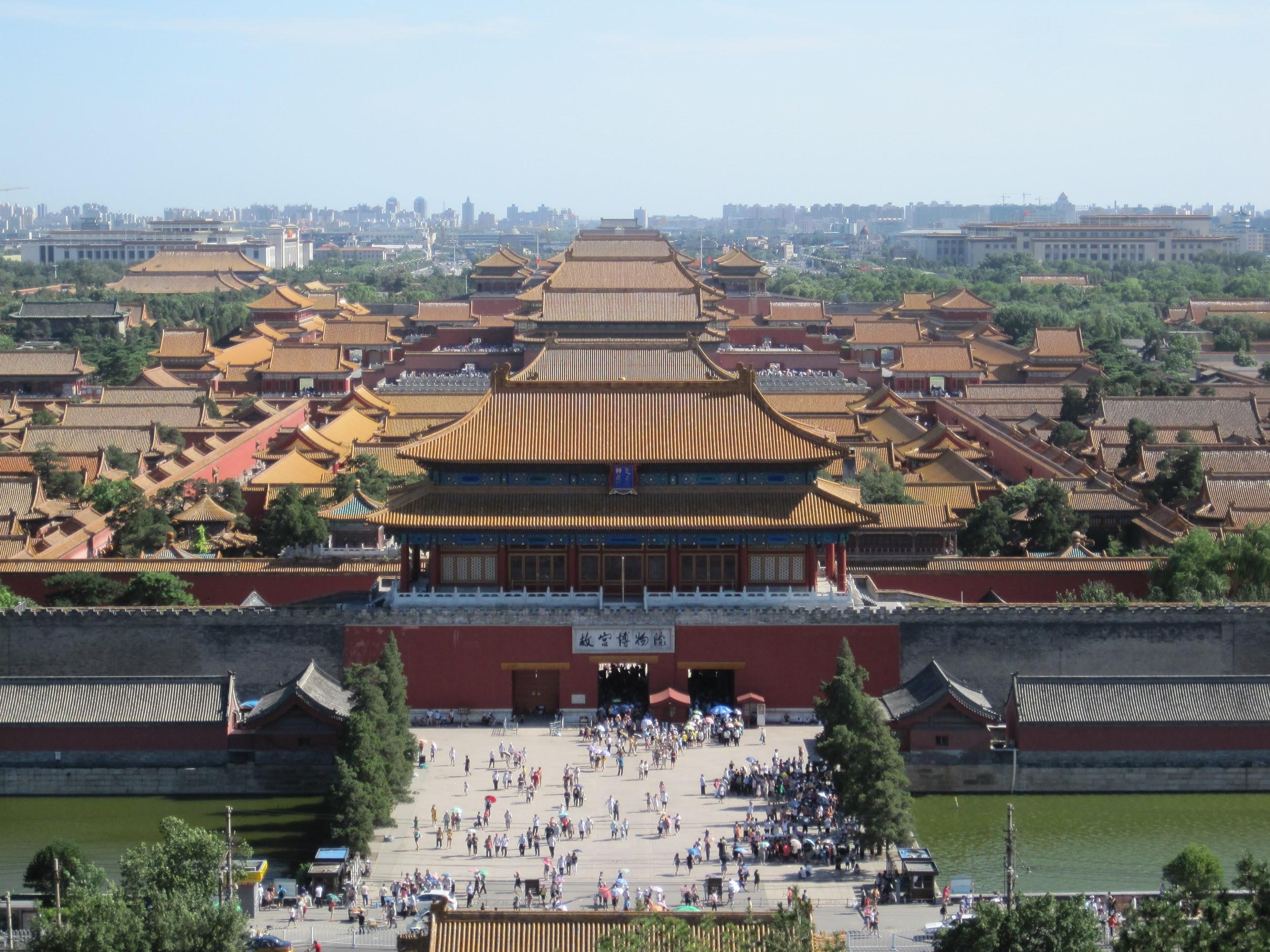
So, what was the Forbidden City for? It was a huge palace built in the Ming Dynasty capital of Beijing (Fig. 11.1). The name (Zijincheng in Chinese) gives away one of its key features: access was limited, if not forbidden. Only the emperor had full access to the city while the imperial family and high officials had limited access. Certainly no one outside those highest circles would be allowed to enter. This all changed when the final Chinese imperial dynasty (the Qing Dynasty; 1644-1911/12 CE) was overthrown in the Chinese Revolution. From 1914-1925 CE, the palace transitioned into the Palace Museum, one of the most important tourist locations in China today. Did you notice all the tourists in Figure 11.4?
The Forbidden City is heavily influenced by the principles of feng shui (literally “wind water”; the practice of arranging things according to a philosophy of space and environment, wherein cardinal directions and natural elements are particularly important). For example, the primary buildings of the Forbidden City, such as the Taihedian (Hall of Supreme Harmony), face south in reverence of the sun. The emperor’s dragon throne sits in the Taihedian, atop three levels of white marble platforms that dwarf any visitor in the surrounding plaza.
The Taihedian is the largest surviving wooden building in China. The building exemplifies ‘traditional Chinese architecture’ through the use of a pillared structure, bracketing system supporting a ceramic tile roof, and perhaps the most visually prominent feature: upturning eaves (Fig. 11.5). Let’s talk about the roof first. Look closely at Figure 11.5. Notice at the end of the eave (the projecting part of the roof), there are circular outlines arranged in a continual horizontal row. What are those? They are simulated ends of bamboo stalks! In fact, traditional curved roof tiles are arranged to simulate pole-like features that descend from the roof ridge to the edge. Any guesses that those pole-like features were? Yep … bamboo stalks! Before the invention of ceramic tiles, roofs were surfaced with bamboo. Bamboo is an auspicious (and highly renewable) plant in China, symbolizing prosperity and longevity. That’s a good material for the roof over your head! When ceramic tiles came on the scene, they simulated the original bamboo roof surface.
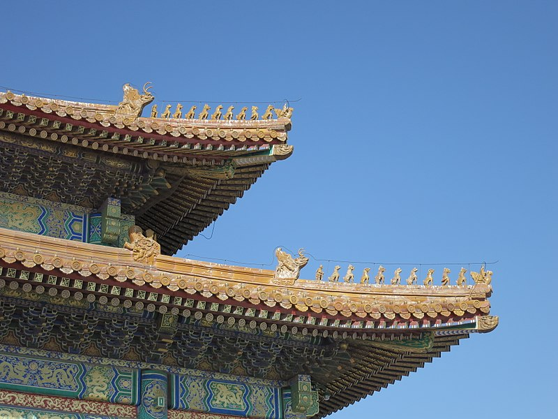
Continue looking closely at Figure 11.5 to notice the layers of supportive brackets on the underside of each eave. This exemplifies the traditional dougong bracketing system. Ceramic tile roofs are super heavy! Then add all the finials and sculptures (which we’ll talk more about in “Why Do They Have More Than Us?”). Then add layers of snow in the winter, and you may have some worries about that roof coming down on you! That’s where the wooden bracketing system comes in. Brackets extend from the walls of the building to the eaves, ensuring that the weight of the roof is balanced. At the Taihedian, the lower roof level depicted in Figure 11.5 has four layers of brackets while the upper level has five layers. Want to see dougong in more detail? Check out Jie Zhang and colleagues (2018) article “Experience the dougong construction in virtual reality,” including the video below the article.
The dougong system is what supports the signature upturning eaves. Most scholars think that the upturned roof corners have both a practical and aesthetic function. Practically, curving the eaves up helps to prevent damage due to snow build-up (which can be quite high in this northeastern part of China). Visually, the curving corners of the roof appear like wings, perhaps of an auspicious phoenix, about to take flight (see Fig. 11.4). This offers a mystical and metaphorical aura to these large buildings that goes beyond humbling a visitor due to size by adding spiritual and cosmological power to the mix.
What other monuments have you heard of? Does Figure 11.6 ring any bells? The ahu and moai of Rapa Nui are extremely famous around the world, but perhaps not by those names. Rapa Nui is the indigenous name of the place that Europeans called Easter Island or Paasch-Eyland (the original name from Dutch explorer Jacob Roggeveen in 1722 CE) (Fig. 11.1). This place wasn’t a barren, uninhabited island; it was home to the Rapa Nui culture. Roggeveen’s visit was not a peaceful one. It ended in the death of a Rapa Nui chief and a dozen others. Spanish slave raiding from the Peruvian coast, forced migrations, and diseases eventually devastated the Rapa Nui population, contrary to Jared Diamond’s incorrect ‘ecocide’ theory in Collapse. To learn more about this ‘ecocide’ theory and why it’s wrong, read “What Really Happened on Easter Island?” (Jarman 2018) to learn more.
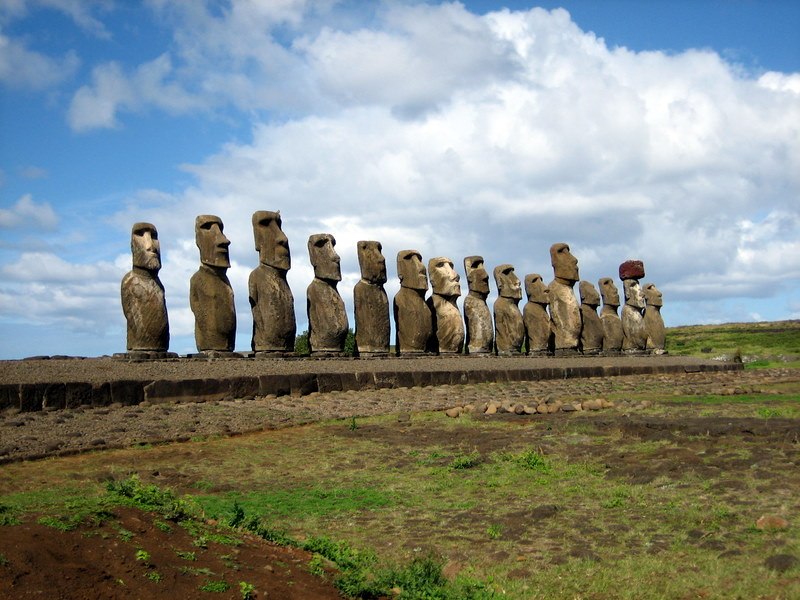
If you are familiar with Squidward’s house in Spongebob, you’ve seen how so-called ‘Easter Island Heads’ are presented in popular media. ![]() As Figure 11.6 demonstrates, these monuments are certainly not just heads. All moai were carved with a torso, arms usually placed beneath the belly bulge, and curvature of the upper hips. The head of each moai typically is large in proportion to the body features. These are monolithic (carved from one stone) basalt statues and range up to 33 feet tall and over 80 tons. Figure 11.6 also illustrates a feature that is often lost in popular media: all moai would have worn a pukao (a separate, often contrasting, stone representing a headdress or hairstyle). Only the moai second from the far end in Figure 11.6 retains its pukao today.
As Figure 11.6 demonstrates, these monuments are certainly not just heads. All moai were carved with a torso, arms usually placed beneath the belly bulge, and curvature of the upper hips. The head of each moai typically is large in proportion to the body features. These are monolithic (carved from one stone) basalt statues and range up to 33 feet tall and over 80 tons. Figure 11.6 also illustrates a feature that is often lost in popular media: all moai would have worn a pukao (a separate, often contrasting, stone representing a headdress or hairstyle). Only the moai second from the far end in Figure 11.6 retains its pukao today.
Ahu are the platforms built to showcase a collection of moai. Each statue is a monument itself but as a collection, the constructions like Ahu Tongariki (Fig. 11.6) are a form of monumental architecture, designed and arranged to impact local communities. Importantly, moai were never intended to be presented individually. Photos of individual moai, often leaning on hillsides, document the several abandoned statues that were never transported to their final ahu setting. That begs the questions that many archaeologists have attempted to answer: how did the Rapa Nui transport these monoliths from the quarries located on the volcanic hills of the island interior to the coastal regions where all ahu are found?
It wasn’t aliens! Archaeologists have developed several hypotheses about how human laborers transported moai based on archaeological evidence and discussion with Rapa Nui people today. Two of the primary hypotheses suggest that transportation was achieved through log rolling and/or upright shimmy-ing (illustrated by Fernando Aptista for National Geographic here). All of these methods required large groups of participants and thus would be conspicuous to the wider community.
So, who do the moai represent? The answer harkens back to our “Who Came Before Us?” chapter. Any guesses? They are portraits of ancestral chiefs, the previous community leaders who continued to protect the community in death. The moai look out over the community (i.e. into the island and not out to sea like erroneous reports state). Recent archaeological surveys suggest that ahu locations may have been chosen based on their proximity to freshwater sources like springs and ponds (DiNapoli et al. 2019). Freshwater is a protected resource in most island societies. You’ve got plenty of water, but not necessarily enough to drink. Thus, the ancestral chiefs would protect a valuable resource while overseeing the living community. These ahu sites also likely served as ceremonial spaces where rituals to honor the previous leaders took place. After learning this about the moai, Anecia Smith re-imagined what the colonial encounter could have been like in Thank You Ancestors!
While the moai are commonly known today, you may not know that just before Roggeveen and other European arrivals, Rapa Nui spiritualism was changing. There was a shift away from the moai-focused ancestor worship to Birdman rituals, associated with the god Makemake. The Birdman role was earned each rainy season by a Rapa Nui man through a feat of prowess and strength. Scholars suggest that this shift in focus may explain why several carved moai were abandoned on hillsides during the transportation process. The Birdman tradition took hold so much so that the Rapa Nui started disassembling ahu and recarving moai to reflect the new spiritual focus. This history has only recently started to come to light as scholars actually ask Rapa Nui people about their own history. Go figure…
The monuments you may not know
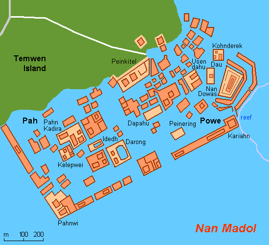
Now, let’s consider some other monuments that don’t make it into most history books. Imagine another small island in the middle of the Pacific Ocean, where coral reefs are abundant and trees crowd the coastline. You probably don’t expect this little island to host one of the largest architectural complexes known in Polynesia. Temwen island is part of the present-day Federated States of Micronesia (Fig. 11.1; north of Melanesia and east of the Philippines) and associated with the larger Pohnpei island. Pohnpeians of the Saudeleur Dynasty built over 90 artificial islands and interlacing canals atop a coral reef off the Temwen coast starting in 1200 CE (Fig. 11.7). Over 500 years, the complex, known as Nan Madol or Soun Nan-leng, grew into a city with a royal palace (the Nan Dowas), religious center dedicated to an agricultural deity called Nahnisohn Sapw (the Powe), fortress, marketplace, government buildings, homes for 500-1000 people, and tombs.
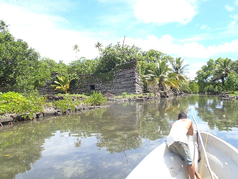
The building methods of the Pohnpeians are unique to the region. Scholars are unsure how the builders were able to securely sink large basalt boulders atop the coral reef and stabilize them for construction of buildings. However they did it, they were successful because the complex survives to this day. The above-water structures (Fig. 11.8) feature a stacked construction method of large basalt stones, similar to log cabins. Importantly, the Pohnpeians did not require any bonding materials. Their construction methods produced stable structures without the need for mortar or adhesives, with the tallest walls reaching 25 feet in the Nan Dowas. This technique is a type of dry construction that is relatively rare around the world, and leads us to our next stop: Zimbabwe.
Zimbabwe is a country in southern Africa (Fig. 11.1) that only recently gained independence from British colonization in 1980 CE. That colonial history will come up a bit later but first, let’s consider the monumental architecture of this region, known as zimbabwes, or stone houses primarily reserved for leaders. The largest of all zimbabwes is the Great Enclosure (Fig. 11.9) of the ancient city known as Great Zimbabwe. Like the Pohnpeians, the builders of Great Zimbabwe perfected a dry masonry technique using local granite.
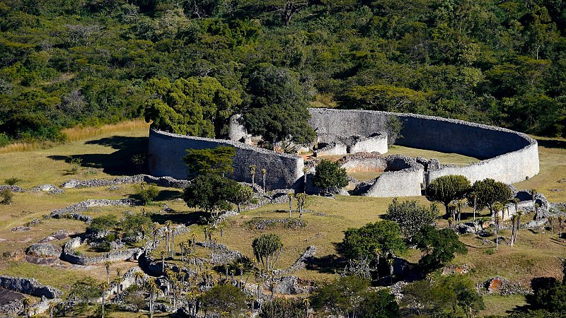
The dry stone technique was used to construct circular walls that surrounded and subdivided living and ceremonial spaces. The Great Enclosure likely hosted the king’s palace and court. The interior of the Great Enclosure originally featured many small buildings constructed using wet clay soil, known as dhaka, and thatched roofs. In front of the Great Enclosure in Figure 9 are the so-called ‘Valley Ruins,’ which were smaller walled compounds probably housing elite families and officials devoted to the kingly court. Farther from the Great Enclosure, archaeologists have found evidence of dhaka-based houses and compounds scattered across the landscape. These were the homesteads of cattle herders that lived around Great Zimbabwe and contributed to its large ranching and trade economy. Artifacts found at the site attest to long-distance trade relationships with the Swahili peoples of the East African coast, and through them, to the Indian Ocean trade networks including the Arab World, India, and China. The population of Great Zimbabwe probably reached around 20,000 people around 1350 CE.
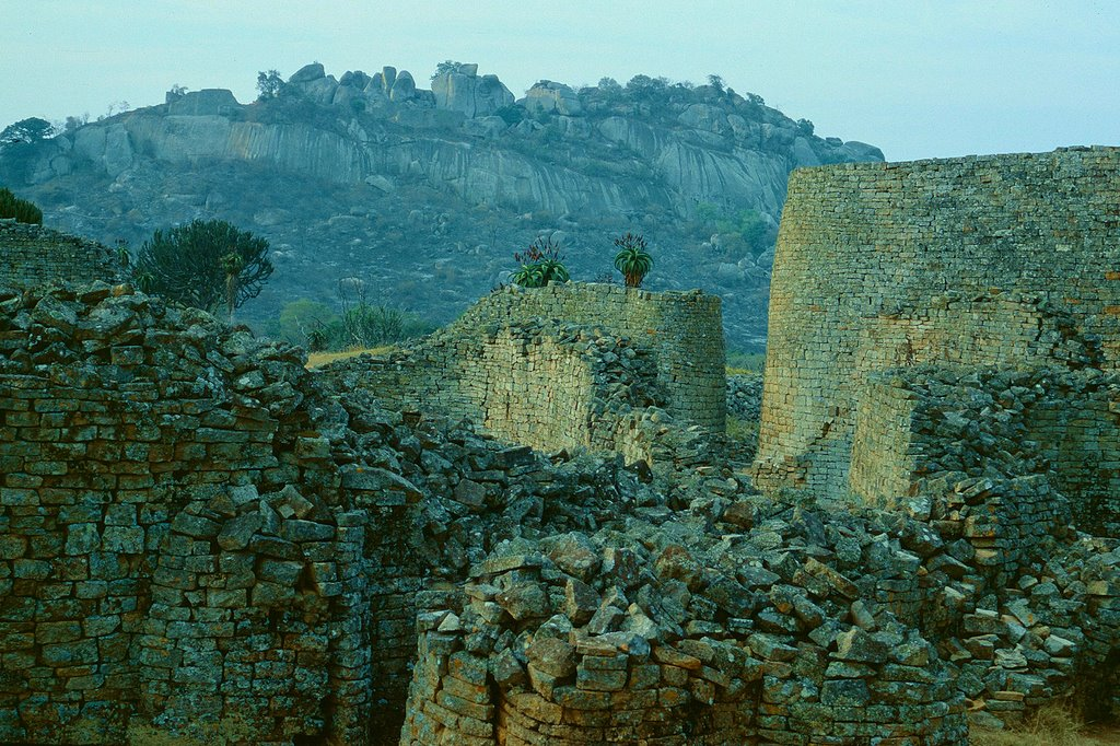
Great Zimbabwe is also known for the monumental Hill Complex, located across the valley from the Great Enclosure (Fig. 11.10). As the name implies, the Hill Complex is higher in elevation and overlooks the entire city and surrounding homesteads. Zimbabwean builders created a series of enclosures among the enormous boulders of the granite outcrop atop the hill. Most scholars think that the Hill Complex served ceremonial purposes because it features a naturally occurring cave/echo chamber within the outcrops that amplifies voices across the valley landscape. This natural feature was enhanced by monumental construction and decorative features such as the ‘Zimbabwe bird’ sculptures. Check out “The Soapstone Birds from Great Zimbabwe” (Huffman 1985) to learn more.
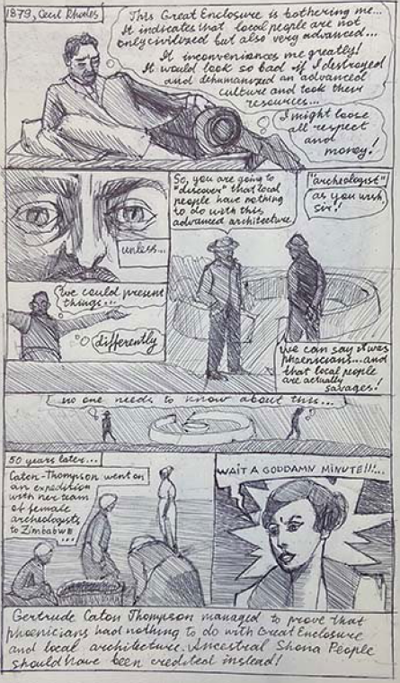
Great Zimbabwe is not only monumental in scale and achievement but in historical significance for other reasons. After initial contact by the Portuguese, other Europeans made their way to southern Africa. By the 1820s CE, land grabbing had pushed a faction of indigenous Zulu peoples, called the Ndebele, from the southern coasts north into what we call Zimbabwe today. In the 1880s CE, a British mining company run by Cecil Rhodes received mining rights from the Ndebele leader, focused primarily on local gold and coal resources. Rhodes then convinced the British government to grant him and his company a royal charter (meaning colonizing rights) to the region. This established what is known as “company rule” (also relevant to the British East India Company), whereby the company’s leadership (i.e. Cecil Rhodes) takes on political authority of the chartered region and combats local insurrections through force (with the armed British South Africa Police). Through war and political moves, Rhodes eventually ruled over what became known as Rhodesia, which later split into northern territories (present-day Zambia) and Southern Rhodesia. During this time, Rhodes welcomed European settlers, displaced indigenous populations, and instituted some of the most racist laws known in Africa at the time. In 1925 CE, Southern Rhodesia officially became part of the United Kingdom/British Empire.
Throughout this period of Rhodes’ rule, African independence/nationalist movements were growing in response to terrible colonial treatment. Rhodes sought a way to justify white rule and developed a propaganda strategy centered on Great Zimbabwe. When the first Portuguese viewed Great Zimbabwe and other similar cities, they weren’t convinced that Black Africans could have achieved such grandeur, fueled by the racist mindsets of the colonial period. Rhodes ran with this idea and hired Theodore Bent (an amateur archaeologist) to conduct excavations at Great Zimbabwe. No matter what was actually found, Bent was to report that evidence revealed the identity of Great Zimbabwe’s builders as non-Black peoples. There were many potential candidates for these builders: King Solomon and the Queen of Sheba, Phoenicians, or Arabs. From 1906 to 1929 CE, archaeologists David Randall-MacIver and Gertrude Caton-Thompson both reported scientific evidence that Great Zimbabwe was built around 1200 CE (thus much too late to have been built by Solomon/Sheba or the Phoenicians) and held no evidence of Arab occupation, except for small trade goods. In Caton Thompson’s (1931: 199) words:
Examination of all the existing evidence … still can produce not one single item that is not in accordance with … Bantu [indigenous African] origin and medieval date. This interest in Zimbabwe … should … to all educated people be enhanced a hundred-fold; it enriches, not impoverishes, our wonderment at their remarkable achievement … for the mystery of Zimbabwe is the mystery which lies in the still pulsating heart of native Africa.
UTA Student Zlata was inspired by Gertrude Caton-Thompson so she applied her drawing skills to produce a comic strip about Gertrude’s contribution to the understanding of Great Zimbabwe. Check it out here.
Unfortunately, Caton Thompson did not change the minds of many Rhodesians, who continued to claim that non-Black people built the ruins. They weren’t about to give up the justification for their settlement since previous non-Black settlement was already present (according to their made-up evidence). This continued into the 1970s CE, after much more archaeological evidence attested to Black African origin and linked to the living Shona culture, subjugated under Rhodesian colonial authority. An archaeologist working at Great Zimbabwe in the 1970s CE said,
I was told by the then-director of the Museums and Monuments organisation to be extremely careful about talking to the press about the origins of the [Great] Zimbabwe state. I was told that … the government was pressuring them to withhold the correct information. Censorship of guidebooks, museum displays, school textbooks, radio programmes, newspapers and films was a daily occurrence. Once a member of the Museum Board of Trustees threatened me with losing my job if I said publicly that blacks had built Zimbabwe. He said it was okay to say the yellow people had built it, but I wasn’t allowed to mention radio carbon dates… (Frederikse 1990).
Such attempts to withhold history and subjugate a culture’s heritage are monumental actions themselves. They impact people profoundly. This suppression lit a fire under the independence/nationalist movement in Southern Rhodesia. A guerrilla war began in 1968 CE while the United Kingdom and Southern Rhodesia struggled internally. In 1980 CE, democratic elections were held and the Zimbabwe African National Union took power, gaining independence from Britain. The new leaders chose that name Zimbabwe to keep their heritage at the forefront of the nation’s identity. They also featured a Zimbabwe Bird on the national flag. Things have not been easy for Zimbabwe since independence but there now is full recognition that the builders of Great Zimbabwe, who achieved monumental things, were the native Black ancestors of the people living in the country today.
How about another example of dry construction? Time for a trip back to Peru. We’ve mentioned the Inka in passing in previous chapters, but let’s dive into the details here. You’ve probably heard of Machu Picchu, a relatively isolated palatial and administrative compound along the vast Inka road system. Machu Picchu is a travel photographer’s dream! But the Inka built much more than that! In fact, on the outskirts of the Inka capital of Cusco, Inka builders constructed a massive fortress and temple complex called Sacsayhuaman (Figs. 11.11 and 11.12).
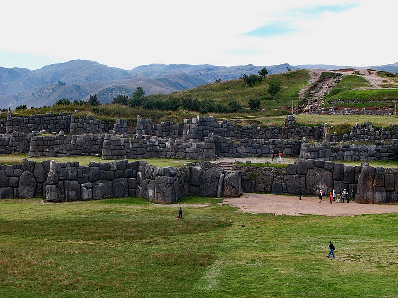
Do you notice the stones in the walls, particularly the lowest wall, in Figure 11.11? Make sure to notice those stones in comparison to the tourists in front of them… talk about monumental! These are called megaliths because they are monoliths but are much larger than typical building stones. The largest stones range from 12-18 feet tall. The walls are dry constructed with precise masonry joints (the contact zones between stones that usually hold mortar but don’t in dry construction). The precision is key with megalithic stones. The stones are carved to fit like a jigsaw puzzle, basically interlocking via gravity and friction. The walls of Sacsayhuaman that remain today survive intact due to the skill of Inka masons. Unfortunately, much of the Sacsayhuaman complex masonry does not remain in its original location anymore because the Spanish removed and recarved stones to build their houses and cathedrals in colonial Cusco.
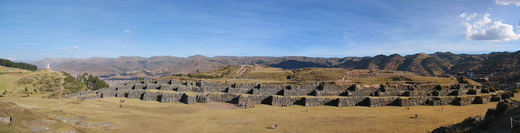
Despite this loss at the site, we can still observe one of the interesting design choices of Sacsayhuaman architects that enhances its monumentality. Take a long look at Figure 11.12. Do you notice the patterning of light and shadow across the facade? That is a result of the projecting design of the walls. Instead of being linear, the walls were designed as a stepped or zigzag pattern (easily seen when viewed from above). At specific times of day, the sunlight casts shadows of the projecting parts into the recesses. Do you notice anything similar to that patterning in Figure 11.12? Cast your eyes to the landscape behind Sacsayhuaman. The mountains surrounding Cusco feature the natural undulating pattern of ridge and valley, creating shadows in the valleys. The Sacsayhuaman architects copied this in their walls. Thus, Sacsayhuaman is like the mighty mountain (extremely important when building a fortress) and cosmologically linked to the dominant forms of the Andes mountains across the Inka empire. As the Song Dynasty painters illustrated for us, mountains are the most monumental thing and our architectural monumentality can only attempt to compare.
Monumental connections
Some monuments offer that feeling of monumentality and cosmological significance to honor one individual. We’ve already covered one of these in “What Happens When We Die?”: Humayun’s tomb! Many funerary traditions around the world feature monumental architecture as the main signifier of the identity of the deceased person. Don’t the Pyramids of Giza pretty clearly indicate that the person buried within isn’t just a regular guy but one of the most important people in the society? That’s the point! The Old Kingdom kings of Egypt (not yet called pharaohs, btw) were the political and social leaders, with strong divine connections (again, they were not yet considered gods themselves). What about the tomb of a religious leader?
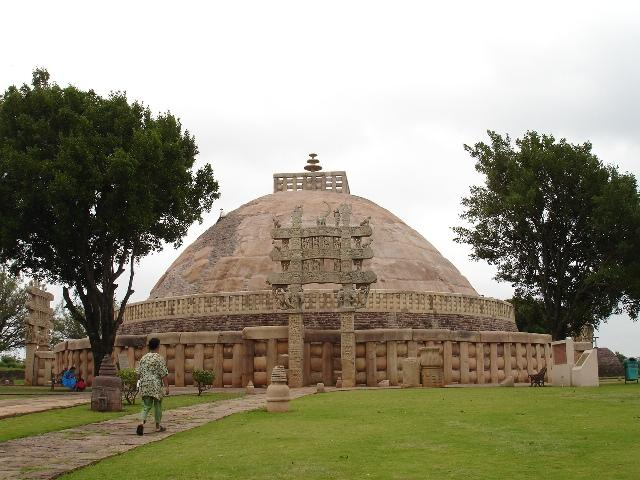
Let’s talk about stupas! Stupa is the Sanskrit word literally meaning “heap,” as in a heap or mound of something. This describes the process of creating funerary monuments for special figures in ancient India: either cremating the deceased and collecting the ashes or positioning their body in a meditation posture and then heaping a lot of soil on top of the ash container or body to create a mound, called a stupa. Most of these stupas were just compacted dirt but eventually, the mounds of very important people’s graves were protected with brick or stone. One of the most famous such mounds is called the Mahastupa (Fig. 11.13), or great stupa, which protects the remains of one of the most important religious leaders of ancient India: Shakyamuni Buddha.
As you know, Shakyamuni lived around 500 BCE, maybe dying in the 400s BCE after many decades of teaching the Middle Way. By that time, he had already gathered many followers. Upon the Shakyamuni’s death, his followers cared for his remains by cremating him. But Shakyamuni was particularly special. So, according to the Buddhist canon, his followers created multiple reliquaries, dividing his ashes, and established stupas at significant locations that represented the stages of Shakyamuni’s life.
Over the years, Buddhism grew and by around 250 BCE, a dominant leader in India, named Ashoka, converted from the Brahmanical tradition to Buddhism. Ashoka’s conversion was quite dramatic. The story goes that Ashoka was fighting against the peoples of Kalinga in east-central India, trying to expand his empire (which was based in northern India). During the battle, Ashoka and his men killed all the Kalinga fighters. Despite victory, Ashoka could only feel remorse. The battle was a massacre. Ashoka looked around the battlefield and asked himself, “What have we done?” At that moment, he turned towards the Buddhist path of moderation, compassion, and nonviolence. As the leader of a large territory, he spread Shakyamuni’s teachings to many people. He did this by erecting monumental pillars and commissioning a grand stupa along the trade routes (to reach the most people). The precise trajectory of Shakyamuni’s remains from the original stupas to the Mahastupa is not known, but Mahastupa is said to contain relics of the Buddha.
In Ashoka’s day, the Mahastupa was just a large mound protected by brick, and may have featured a wooden vedika (fence). Rulers following Ashoka commissioned the encircling stone vedika and monumental toranas (gateways), positioned at the cardinal directions. The toranas feature detailed carvings illustrating the Shakyamuni’s enlightenment story and jatakas (as discussed in “What is Divine?”). In addition, the toranas feature the Vedic and Brahmanical imagery that was taken up by Buddhist arts to maintain familiarity with existing traditions. In fact, the Yakshi sculpture from “Where Do Babies Come From?” (Fig. 9.2) was originally attached to one of the Mahastupa toranas.
This funerary monument is a bit different from other tombs or funerary architecture you might be familiar with because it is a very active site that people visit on pilgrimages. Buddhists practice circumambulation around the Mahastupa. Circumambulation can be practiced by anyone and basically means walking around or walking in a circle, but it is more than that for Buddhists. It is a meditative practice (a form of walking meditation) focused on the presence and imagery of the Buddha. The vedika separates the outer world from the inner world. When one enters one of the four toranas, one passes into the inner world and releases the outer, material world from one’s mind. Stupas also feature a yasti (seen at the very top of Fig. 11.13), or spire that typically holds three umbrella-shaped objects called chattras. These umbrellas/parasols represent royalty, reflecting Shakyamuni’s noble origins and Ashoka’s patronage. The yasti forms a central axis for the stupa, directly over the Buddha’s relics protected inside.
As people walk within the vedika, they are close to the massive mound and to the relics of the Buddha. This presence inspires meditative insight. One might also circumambulate in the company of a monk who can help explain a particular concept, using the carved imagery as illustrations. Did you notice the second level in Figure 11.13? There’s an inner and elevated circumambulation path that was built later. It features its own stone vedika, creating an even more intimate meditative space alongside the mound. In this way, a funerary monument becomes a temple.
As we’ve discussed, Buddhism didn’t stay in Nepal and India for long. It spread quickly north to Tibet and south to Sri Lanka. From Sri Lanka, Buddhism spread across the ocean to Southeast Asia and became particularly influential in Indonesia. Buddhism became the official tradition of the Sailendra Dynasty of the island known as Java today (Fig. 11.1). Over a century after the Buddha’s death, the Sailendra rulers commissioned the largest Buddhist temple in the world. Borobudur (Fig. 11.14) is a temple that builds upon the imagery of an Indian stupa but takes it to another level.
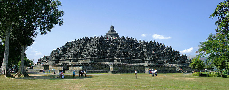
Borobudur features nine platforms, with six square platforms stacked at the bottom and three circular platforms at the top. Each platform is connected via four staircases, each positioned at the cardinal directions. At the very top, there is a central stupa. Throughout the temple, there are over 500 statues of the Buddha and almost 100 miniature stupas.
The overall design is a hybrid of indigenous Javanese spiritual architecture, focused on the simulation of mountainous forms (because indigenous ancestor worship acknowledged that hyangs [ancestral spirits] lived in the mountains of the island) and imported Buddhist architecture. In fact, archaeologists have documented an early building at the site (buried deep beneath the temple seen today) that was probably devoted to indigenous ancestor worship before the Sailendra created their Buddhist monument.
So what do you think happens at Borobudur? Circumambulation! … on steroids. There are nine levels to circumambulate, each reflecting a different component of Buddhist teaching. There are almost 1,500 carved panels depicting important events in the Buddha’s lives and other compelling imagery to help pilgrims meditate. This unique Javanese architectural form serves the traditional practices of Buddhism very well but also incorporates the ideals of the indigenous spiritual system, offering connections to local origins and the wider world.
Eventually, the people of Java and many others in Indonesia converted to Islam and monuments like Borobudur were no longer used. Islam developed in Mecca, Saudi Arabia, where the Prophet Muhammed lived, and spread quickly across Asia, building a vast network of connected masjids (mosques). This facet of monumental connection is incredibly important in Islam. All masjids, anywhere in the world, are designed to face Mecca and a particular structure in Mecca: the Kaaba, which sits within the Masjid al-Haram (Fig. 11.15).
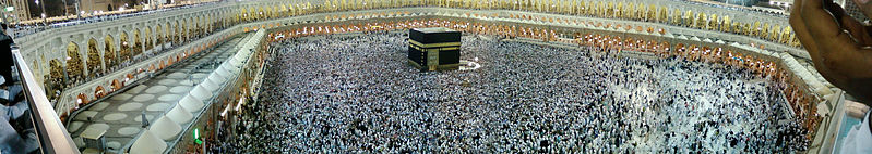
The Kaaba is a long-lived holy place. Muslims believe that the Kaaba was built by Abraham and his son while other believe that the structure was originally erected by pre-Islamic Arab peoples of the Arabian desert. Arab peoples called Bedouins lived migratory lives around the desert and would congregate in Mecca (one of the few permanent settlements in the region, centered on an oasis) at certain times of year. According to their histories, the original Kaaba shrine was their primary destination as a centralized place to worship their gods. Mecca and the Kaaba were already extremely significant to the societies of the Arabian desert. In the late 500s and early 600s CE, Prophet Muhammed and the earliest Muslims challenged the leaders of the Quraysh, a prominent Bedouin tribe, for control. Their conflict had political and spiritual dimensions, with tension between the polytheistic non-Islamic Arab beliefs and the monotheistic beliefs of Islam. Eventually, the Prophet Muhammed and his followers overthrew the Quraysh and established permanent Muslim presence in Mecca.
The Kaaba has been preserved to this day as a small (approx. 36 x 42 x 43’) structure of marble and limestone, protected by a special black embroidered covering called the Kiswah. The Masjid al-Haram surrounding the Kaaba has grown immensely over time, including through multiple rebuilding, and is now recognized as the largest masjid in the world. Patrons have expanded the masjid, adding more and more space to accommodate the vast number of Muslims who make the annual Hajj (pilgrimage) to Mecca (almost 2.5 million in 2019 CE) and/or visit year round. The Hajj brings pilgrims to the masjid, to direct their prayer toward the Kaaba and practice the tawaf (ritual circumambulation around the Kaaba). In fact, in recent years, a three-story temporary structure has been erected in the courtyard surrounding the Kaaba to allow more pilgrims to practice tawaf at one time.
As noted above, all masjids are connected to the Kaaba and to Mecca. One of the most interesting contemporary masjids in the world is the Faisal Masjid (Fig. 11.16), designed by Vedat Dalokay for Islamabad, Pakistan. Like all masjids, the Faisal Mosque contains a prominent wall, called the qibla wall, within which a niche or similar feature, called a mihrab, is located. Architects today often experiment with qibla and mihrab traditions. For example, Dalokay created a faux-niche out of a large sculpture of an open Qur’an (see in the far left of Fig. 11.17 above the worshippers) for the Faisal Masjid.
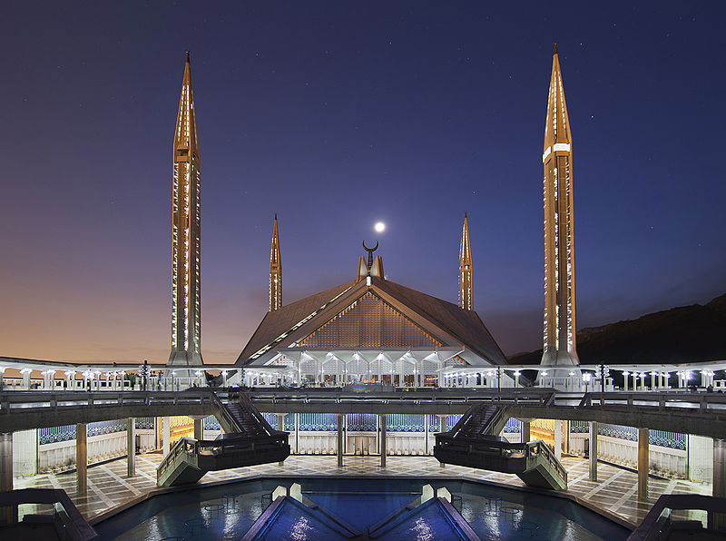
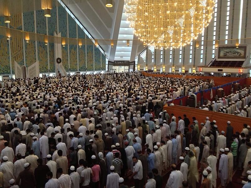
Dalokay incorporated links to traditional features like mosaics on the qibla wall. Dalokay’s design provides the traditional spaces for worship (prayer hall) and congregation (courtyard) but the overall visual quality of the masjid does not feature traditional domes, columns, and arches of famous historic masjids. Check out the Great Masjid of Damascus (Fig. 11.18) to explore traditional masjid design.
In fact, the Faisal Masjid resembles a Bedouin tent, created from a large textile stretched over supports and anchored to the ground by ropes (check out some traditional Bedouin tents here). Figure 11.17 illustrates the intentional placement of windows to simulate the pops of sunlight entering a tent through small openings in the fabric covering. This design choice clearly highlights the origins of Islam in the Arabian desert. As Fig. 11.16 also illustrates, beyond the main prayer space (the tent-like structure), the complex also includes a large courtyard dominated by a pool of water. This is a traditional feature in masjids, used to clean one’s feet before entering the prayer hall and alluding to the importance of water in the desert.
The other features of note are the four towering minarets, towers traditionally used by a muezzin to call the local community to prayer (by projecting a spoken/sung message from a height). It is important to note that Dalokay is a Turkish architect from Istanbul who studied the grand Ottoman-era masjids there. Ottoman architects were known for so-called ‘pencil’ minarets that were tall and slender, as seen at Hagia Sophia today. Dalokay was clearly inspired by those origins for the design of his minarets. The Faisal Masjid incorporates traditional requirements through contemporary experimentation. It is connected to Mecca and the Kaaba, as all masjids should be, but it offers a distinct way of engaging the past.
Speaking of connections, in the next section we’re moving from Mecca across the Red Sea (separating the Arabian Peninsula from north Africa) to Ethiopia (Fig. 11.1). There are strong historical connections between these regions, primarily relating to trade across the easily navigable sea. Another important connection occurred during the Prophet Muhammed’s lifetime. When he and his early followers were kicked out of Mecca by the Quraysh, Muhammed went to Yathrib (now Medina, Saudi Arabia) but sent many of his followers across the sea into the territory of the Orthodox Christian Kingdom of Axum (which spanned present-day Ethiopia, Eritrea, and eastern Yemen). Around 615 CE, when early Muslims needed refuge, the Axumites welcomed them. This event became known as the first hijra (migration) and marks an important example of interfaith relationships that we will continue exploring in “Can we live together?”
Beyond built monuments
So, what monuments are the Axumites of present-day Ethiopia known for? In the early periods, they carved and erected tall towers to mark royal graves. Kings descended from the Axumites continued the tradition of stone carving and accomplished quite a unique architecture feat.
Firstly, we must recognize that architectural monuments don’t necessarily have to be built, meaning from the ground up, stone on top of stone. There are rare cases when builders are actually carvers, chiseling buildings out of cliff sides or bedrock. This is called ‘rock-hewn’ or ‘rock-cut’ architecture. Many examples are Buddhist and Hindu cave temples and monasteries such as the famous Ajanta caves in India. Another set of spectacular rock-hewn examples were commissioned for Lalibela, Ethiopia, by an Axumite descendant, King Gebre Mesqel Lalibela. He sought to recreate Jerusalem, one of the most important locations within the Christian religious tradition, on his doorstep. Eleven rock-hewn churches were produced to make this vision a reality. The most famous is Bete Giyorgis (Figs. 11.19 and 11.20).
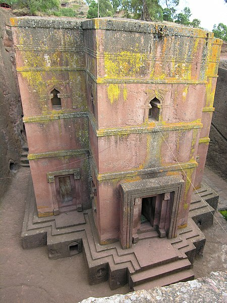
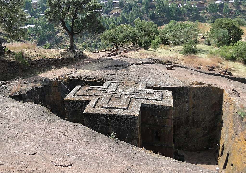
Just take a moment to consider what you are seeing in Figure 11.20. Carvers started from the rock surface that the photographer is standing on, removing an immense volume of stone to isolate a cross-shaped structure in the center of a square pit. You may be wondering… “okay, but how do you get down to the actual church?” There’s a built-in/carved-in staircase! The carvers also created a series of artificial caves (entered from the sidewalls) that housed priests and served as tombs.
Rock-hewn architectural processes are quite distinct to ground-up processes. For example, carvers have to know exactly what form they want to achieve before they begin. If you are building by stacking stones or wood, you can design as you go (to an extent) but carving takes a lot more planning. It also is more labor intensive, so much so that the carvers who worked on these rock-hewn churches were said to have remarkable religious devotion (to stick with it). But, no human is perfect, right? So the story goes that when carvers got fatigued and laid down their tools, angels would pick them up and continue the carving. Thus, Ethiopians believe that the rock-hewn churches were only completed with divine intervention.
While the Lalibela rock-hewn churches are Christian monuments, rock-cut architecture in this region probably started among the pre-Chrisitian Axumites and may have been inspired by the traditions of India described above. Just like Great Zimbabwe, Ethiopia engaged in Indian Ocean trade networks that brought items and ideas from distant lands. We’ll explore those processes in the next chapter “What Do I Get Out of It?”
The Wrap-up
This chapter was pretty monumental, huh? (I seek no pardon for that pun. It was very intentional!) We humans get a kick out of big things. Have you ever visited any of the “world’s largest” tourist attractions often stationed along highways in the US? For some reason, we get excited about the World’s Largest Ketchup Bottle (in Collinsville, Illinois) or the World’s Largest Grandfather Clock (in Kewaunee, Wisconsin). Consider what role monumentality plays in your life by exploring media and scholarly sources on the topic.
News Flash
- Check out “Inside Mecca,” a documentary about the pilgrimage and its major sites.
- The Faisal Masjid is featured in Khalid Hosseini’s famous novel The Kite Runner (which was made into a film).
- In addition to Squidward’s House, a moai is portrayed in the 2006 comedy film “Night at the Museum.”
- The 1987 epic biographical film “The Last Emperor” follows the life of Pu-yi, the last emperor of the Qing Dynasty, and heavily features the Forbidden City.
- Check out the video game “Civilization VI” to explore a virtual version of Nan Madol!
Where Do I Go From Here? / The Bibliography
Farriss, Nancy M. 1984. Maya Society under Colonial Rule: The Collective Enterprise of Survival. Princeton: Princeton University Press.
Veblen, Thorstein. 1899. The Theory of the Leisure Class. United States: Macmillan.

.jpg)
.jpg)